TopoQuest Logo
Do you find TopoQuest useful?
Help keep TopoQuest running and adding new maps/features by donating!
Bitcoin:  19c7KJd3qBynnjoSw5npx9KScwjBe4ifkT
Litecoin:  LXs6TkuXGGXo1vDsWCkWVdjQX94eUKd6ui
Home View Maps Find Maps Find Places Resources & Links


Catawba, South Carolina Topographic Map

USGS Map Title: Catawba, SC
USGS Map MRC: 34080G8
DRG (GeoTIFF) Download: o34080g8.tif


Neighboring USGS Topographic Map Quads:


  Rock Hill West, SC  
34081H1
 

  Rock Hill East, SC  
34080H8
 

  Catawba NE, SC  
34080H7
 

  Edgemoor, SC  
34081G1
 

  Catawba, SC  
34080G8
 

  Van Wyck, SC  
34080G7
 

  Richburg, SC  
34081F1
 

  Fort Lawn, SC  
34080F8
 

  Lancaster, SC  
34080F7


Map MRC Location:

N35°
W81°
N35°
W80°
H8 H7 H6 H5 H4 H3 H2 H1
G8 G7 G6 G5 G4 G3 G2 G1
F8 F7 F6 F5 F4 F3 F2 F1
E8 E7 E6 E5 E4 E3 E2 E1
D8 D7 D6 D5 D4 D3 D2 D1
C8 C7 C6 C5 C4 C3 C2 C1
B8 B7 B6 B5 B4 B3 B2 B1
A8 A7 A6 A5 A4 A3 A2 A1
N34°
W81°
N34°
W80°

Catawba, SC USGS 1:24K Topographic Map Preview:
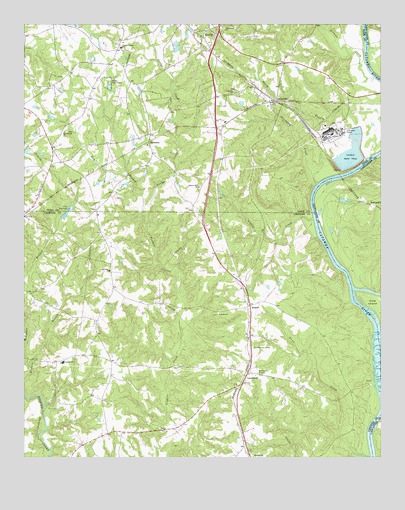
Catawba, SC USGS Topographic Map
Click on map above to begin viewing in our Map Viewer.

This topographic map contains these locations and features:
Feature Name Type Latitude Longitude GNIS ID View Map
Abernathy CreekStreamN34.8290°W80.8970°1220118View Map
Bethel ChurchChurchN34.7915°W80.9312°1220574View Map
Boyds Pond FourReservoirN34.8501°W80.8915°1237654View Map
Burkette LakeReservoirN34.8668°W80.9548°1240356View Map
Burkette Lake Dam D-3679DamN34.8668°W80.9548°1240355View Map
CatawbaPopulated PlaceN34.8529°W80.9112°1249459View Map
Catawba Baptist ChurchChurchN34.8554°W80.9265°1247186View Map
Catawba Census Designated PlaceCensusN34.8464°W80.9061°2629820View Map
Catawba Chapel African Methodist Episcopal Zion ChurchChurchN34.8515°W80.9142°1233631View Map
Catawba Church (historical)ChurchN34.8463°W80.8998°1233632View Map
Catawba School (historical)SchoolN34.8518°W80.9142°1237452View Map
Catawba School (historical)SchoolN34.8460°W80.8995°1233637View Map
Culp IslandIslandN34.7935°W80.8765°1247462View Map
Dunn CreekStreamN34.7501°W80.8787°1222153View Map
Elbethel ChurchChurchN34.7510°W80.9195°1247648View Map
Elbethel School (historical)SchoolN34.7507°W80.9195°1230675View Map
Fort Lawn DivisionCivilN34.7513°W80.9355°1938326View Map
Greene CreekStreamN34.8190°W80.8984°1222889View Map
HarmonyPopulated PlaceN34.8401°W80.9556°1231364View Map
Harmony Baptist ChurchChurchN34.8040°W80.9698°1245914View Map
Harmony School (historical)SchoolN34.8032°W80.9690°1230699View Map
Indian Ferry (historical)CrossingN34.8335°W80.8826°1251746View Map
Lando Fire Department Killian Road StationBuildingN34.7980°W80.9675°2578562View Map
Lando SchoolSchoolN34.7774°W80.9862°1246288View Map
Lands FordCrossingN34.7724°W80.8751°1230706View Map
LandsfordPopulated PlaceN34.7746°W80.9212°1227932View Map
Landsford CanalCanalN34.7788°W80.8779°1230707View Map
Landsford Canal State ParkParkN34.7799°W80.8781°1230708View Map
Landsford ChurchChurchN34.7713°W80.9231°1242279View Map
Landsford PlantationLocaleN34.7585°W80.9195°1230709View Map
Landsford School (historical)SchoolN34.7746°W80.9184°1230710View Map
Lesslie Fire Department Station 3BuildingN34.8561°W80.9323°2578894View Map
Liberty Hill ChurchChurchN34.8282°W80.9384°1223890View Map
Liberty Hill School (historical)SchoolN34.8276°W80.9387°1233783View Map
McFadden BranchStreamN34.7771°W80.9984°1224404View Map
Mount Calvary ChurchChurchN34.8440°W80.9856°1224694View Map
Mount Calvary School (historical)SchoolN34.8438°W80.9859°1233801View Map
Mount Zion ChurchChurchN34.7746°W80.9176°1224839View Map
Mount Zion Recreation CenterBuildingN34.7818°W80.9195°1242280View Map
Neelys CreekStreamN34.8163°W80.9576°1224946View Map
Neelys Creek Associate Reformed Presbyterian ChurchChurchN34.8685°W80.9656°1249780View Map
Rock Water Spring BranchStreamN34.7571°W80.8776°1225950View Map
RoddeyPopulated PlaceN34.8710°W80.9367°1250457View Map
Roddey Baptist ChurchChurchN34.8701°W80.9351°1233884View Map
RowellPopulated PlaceN34.7940°W80.9206°1250478View Map
Rum BranchStreamN34.8160°W80.9576°1226067View Map
Sixmile CreekStreamN34.8599°W80.8770°1250913View Map
South Carolina Noname 46017 D-3654 DamDamN34.8451°W80.8831°1238558View Map
South Carolina Noname 46018 D-3655 DamDamN34.8468°W80.8848°1238559View Map
South Carolina Noname 46019 D-3653 DamDamN34.8418°W80.8831°1238560View Map
South Carolina Noname 46020 D-3652 DamDamN34.8385°W80.8865°1238561View Map
South Carolina Noname 46033 D-3656 DamDamN34.8468°W80.8781°1240389View Map
South Carolina Noname 46034 D-3657 DamDamN34.8401°W80.8781°1240390View Map
SpringdellPopulated PlaceN34.8238°W80.8815°1227984View Map
Tabernacle ChurchChurchN34.8743°W80.9301°1227015View Map
Tabernacle School (historical)SchoolN34.8743°W80.9306°1233939View Map
Tinkers Creek WCD Dam Number 21 D-0216DamN34.8051°W80.9531°1238953View Map
Wildewood Pond Four D-0565 DamDamN34.8501°W80.8915°1237653View Map
Worthy Boys CampLocaleN34.8596°W80.9692°1227712View Map

Note: Coordinates in the location and feature list above are referenced to NAD83 datum.


Copyright (C) 2008-2025 Ryan Niemi / Sunset Dynamics ... All Rights Reserved