TopoQuest Logo
Do you find TopoQuest useful?
Help keep TopoQuest running and adding new maps/features by donating!
Bitcoin:  19c7KJd3qBynnjoSw5npx9KScwjBe4ifkT
Litecoin:  LXs6TkuXGGXo1vDsWCkWVdjQX94eUKd6ui
Home View Maps Find Maps Find Places Resources & Links


Auburn, Kentucky Topographic Map

USGS Map Title: Auburn, KY
USGS Map MRC: 36086G6
DRG (GeoTIFF) Download: o36086g6.tif


Neighboring USGS Topographic Map Quads:


  Homer, KY  
36086H7
 

  South Union, KY  
36086H6
 

  Rockfield, KY  
36086H5
 

  Dennis, KY  
36086G7
 

  Auburn, KY  
36086G6
 

  Woodburn, KY  
36086G5
 

  Adairville, KY  
36086F7
 

  Prices Mill, KY  
36086F6
 

  Franklin, KY  
36086F5


Map MRC Location:

N37°
W87°
N37°
W86°
H8 H7 H6 H5 H4 H3 H2 H1
G8 G7 G6 G5 G4 G3 G2 G1
F8 F7 F6 F5 F4 F3 F2 F1
E8 E7 E6 E5 E4 E3 E2 E1
D8 D7 D6 D5 D4 D3 D2 D1
C8 C7 C6 C5 C4 C3 C2 C1
B8 B7 B6 B5 B4 B3 B2 B1
A8 A7 A6 A5 A4 A3 A2 A1
N36°
W87°
N36°
W86°

Auburn, KY USGS 1:24K Topographic Map Preview:
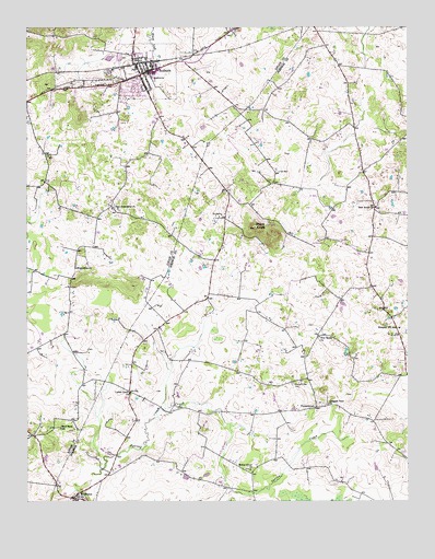
Auburn, KY USGS Topographic Map
Click on map above to begin viewing in our Map Viewer.

This topographic map contains these locations and features:
Feature Name Type Latitude Longitude GNIS ID View Map
AuburnPopulated PlaceN36.8642°W86.7103°486133View Map
Auburn (historical)Populated PlaceN36.7961°W86.7070°2742854View Map
Auburn City Medical ServicesBuildingN36.8640°W86.7083°2636335View Map
Auburn Police DepartmentBuildingN36.8632°W86.7096°2767668View Map
Auburn Volunteer Fire DepartmentBuildingN36.8629°W86.7094°2636558View Map
Bethel Grove (historical)Populated PlaceN36.7585°W86.6757°2742855View Map
Bethel Grove ChurchChurchN36.7581°W86.6764°486997View Map
City of AuburnCivilN36.8654°W86.7106°2403133View Map
Franklin DivisionCivilN36.7509°W86.6254°1937011View Map
Friendship (historical)Populated PlaceN36.8120°W86.7344°2743075View Map
Friendship ChurchChurchN36.8114°W86.7342°492539View Map
Knobs (historical)Populated PlaceN36.8244°W86.6729°2742858View Map
Locust Grove (historical)Populated PlaceN36.7779°W86.7163°2742860View Map
Locust Grove ChurchChurchN36.7787°W86.7161°496951View Map
MiddletonPopulated PlaceN36.7509°W86.7347°498154View Map
New Friendship ChurchChurchN36.8273°W86.7217°499316View Map
New Salem (historical)Populated PlaceN36.7928°W86.6546°2742861View Map
New Salem ChurchChurchN36.7934°W86.6542°499387View Map
Pilot KnobSummitN36.8223°W86.6747°500640View Map
Pilot Knob ChurchChurchN36.8275°W86.6358°500649View Map
Pleasant View CemeteryCemeteryN36.7811°W86.6628°500939View Map
Pleasant View ChurchChurchN36.7753°W86.6511°500943View Map
Prospect HillSummitN36.7953°W86.6280°2742867View Map
Prospect Hill (historical)Populated PlaceN36.7943°W86.6278°2742866View Map
Prospect Hill SchoolSchoolN36.7959°W86.6278°501365View Map
Sand Bank SchoolSchoolN36.7692°W86.7389°502893View Map
SandtownPopulated PlaceN36.7670°W86.7478°2743098View Map
Spring CreekStreamN36.7570°W86.7289°504123View Map
TurnertownPopulated PlaceN36.7748°W86.6553°509249View Map

Note: Coordinates in the location and feature list above are referenced to NAD83 datum.


Copyright (C) 2008-2025 Ryan Niemi / Sunset Dynamics ... All Rights Reserved