TopoQuest Logo
Do you find TopoQuest useful?
Help keep TopoQuest running and adding new maps/features by donating!
Bitcoin:  19c7KJd3qBynnjoSw5npx9KScwjBe4ifkT
Litecoin:  LXs6TkuXGGXo1vDsWCkWVdjQX94eUKd6ui
Home View Maps Find Maps Find Places Resources & Links


Rocky Reef, Montana Topographic Map

USGS Map Title: Rocky Reef, MT
USGS Map MRC: 47111B6
DRG (GeoTIFF) Download: o47111b6.tif


Neighboring USGS Topographic Map Quads:


  Mount Cecelia, MT  
47111C7
 

  Cascade, MT  
47111C6
 

  Nelson Island, MT  
47111C5
 

  Hardy, MT  
47111B7
 

  Rocky Reef, MT  
47111B6
 

  Schrammeck Lake, MT  
47111B5
 

  The Sawteeth, MT  
47111A7
 

  Hound Creek Reservoir, MT  
47111A6
 

  Dana Ranch, MT  
47111A5


Map MRC Location:

N48°
W112°
N48°
W111°
H8 H7 H6 H5 H4 H3 H2 H1
G8 G7 G6 G5 G4 G3 G2 G1
F8 F7 F6 F5 F4 F3 F2 F1
E8 E7 E6 E5 E4 E3 E2 E1
D8 D7 D6 D5 D4 D3 D2 D1
C8 C7 C6 C5 C4 C3 C2 C1
B8 B7 B6 B5 B4 B3 B2 B1
A8 A7 A6 A5 A4 A3 A2 A1
N47°
W112°
N47°
W111°

Rocky Reef, MT USGS 1:24K Topographic Map Preview:
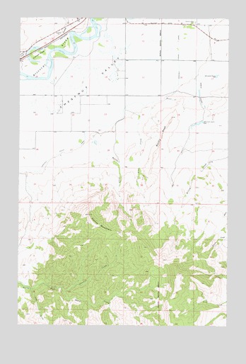
Rocky Reef, MT USGS Topographic Map
Click on map above to begin viewing in our Map Viewer.

This topographic map contains these locations and features:
Feature Name Type Latitude Longitude GNIS ID View Map
17N01E08____01 WellWellN47.2408°W111.6344°821628View Map
17N01E08C___01 WellWellN47.2372°W111.6397°821613View Map
17N01E08D___01 WellWellN47.2372°W111.6291°821612View Map
17N01E29C___01 SpringSpringN47.1933°W111.6397°821352View Map
17N01E29D___01 WellWellN47.1933°W111.6291°821351View Map
17N01E30D___01 WellWellN47.1933°W111.6503°821353View Map
17N01W13A___01 WellWellN47.2294°W111.6711°821580View Map
17N01W13B___01 WellWellN47.2294°W111.6819°821581View Map
17N01W14D___01 SpringSpringN47.2222°W111.6925°821530View Map
17N01W25A___01 SpringSpringN47.2005°W111.6711°821394View Map
17N01W26B___01 SpringSpringN47.2005°W111.7030°821395View Map
17N01W27B___01 WellWellN47.2005°W111.7244°821396View Map
Allen CreekStreamN47.2088°W111.6791°768205View Map
Barrett Field (historical)AirportN47.2372°W111.7430°806379View Map
Bunnell CreekStreamN47.2177°W111.6641°769394View Map
Cascade DivisionCivilN47.1751°W111.6528°1940582View Map
Cherry CouleeValleyN47.2238°W111.6433°769780View Map
Chesnut Valley CemeteryCemeteryN47.2483°W111.6461°769803View Map
Chestnut Post Office (historical)Post OfficeN47.2347°W111.6869°1762440View Map
Chestnut Valley CanalCanalN47.2058°W111.6983°769802View Map
Chestnut Valley School (historical)SchoolN47.2155°W111.6975°1761873View Map
Dana-Cameron Ranch DamDamN47.1983°W111.6425°798368View Map
Harris CreekStreamN47.2022°W111.7025°772166View Map
Harris MountainSummitN47.1655°W111.7030°772173View Map
Rocky ReefRidgeN47.2024°W111.6658°775899View Map
Sawmill CreekStreamN47.1386°W111.7236°776245View Map
Tintinger SloughLakeN47.2375°W111.7428°777681View Map
Willow Creek School (historical)SchoolN47.2111°W111.6333°1761872View Map
Yank CreekStreamN47.1397°W111.7439°778721View Map

Note: Coordinates in the location and feature list above are referenced to NAD83 datum.


Copyright (C) 2008-2025 Ryan Niemi / Sunset Dynamics ... All Rights Reserved