TopoQuest Logo
Do you find TopoQuest useful?
Help keep TopoQuest running and adding new maps/features by donating!
Bitcoin:  19c7KJd3qBynnjoSw5npx9KScwjBe4ifkT
Litecoin:  LXs6TkuXGGXo1vDsWCkWVdjQX94eUKd6ui
Home View Maps Find Maps Find Places Resources & Links


Romulus, New York Topographic Map

USGS Map Title: Romulus, NY
USGS Map MRC: 42076G7
DRG (GeoTIFF) Download: o42076g7.tif


Neighboring USGS Topographic Map Quads:


  Geneva North, NY  
42076H8
 

  Seneca Falls, NY  
42076H7
 

  Cayuga, NY  
42076H6
 

  Geneva South, NY  
42076G8
 

  Romulus, NY  
42076G7
 

  Union Springs, NY  
42076G6
 

  Dresden, NY  
42076F8
 

  Ovid, NY  
42076F7
 

  Sheldrake, NY  
42076F6


Map MRC Location:

N43°
W77°
N43°
W76°
H8 H7 H6 H5 H4 H3 H2 H1
G8 G7 G6 G5 G4 G3 G2 G1
F8 F7 F6 F5 F4 F3 F2 F1
E8 E7 E6 E5 E4 E3 E2 E1
D8 D7 D6 D5 D4 D3 D2 D1
C8 C7 C6 C5 C4 C3 C2 C1
B8 B7 B6 B5 B4 B3 B2 B1
A8 A7 A6 A5 A4 A3 A2 A1
N42°
W77°
N42°
W76°

Romulus, NY USGS 1:24K Topographic Map Preview:
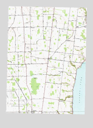
Romulus, NY USGS Topographic Map
Click on map above to begin viewing in our Map Viewer.

This topographic map contains these locations and features:
Feature Name Type Latitude Longitude GNIS ID View Map
Airtrek AirportAirportN42.8475°W76.8517°978353View Map
Burgh CemeteryCemeteryN42.8570°W76.8123°2516735View Map
Burroughs CreekStreamN42.8117°W76.7502°973760View Map
Canoga SpringsPopulated PlaceN42.8512°W76.7666°972297View Map
Cassim FarmLocaleN42.8494°W76.8372°2544112View Map
Clemsons CornersPopulated PlaceN42.8506°W76.8494°2370151View Map
Cobblestone Farm Winery And VineyardBuildingN42.7806°W76.7742°2516773View Map
Cranberry MarshSwampN42.7870°W76.8325°947662View Map
East VarickPopulated PlaceN42.7701°W76.7694°949262View Map
FayettePopulated PlaceN42.8142°W76.8091°949942View Map
Fayette Church CemeteryCemeteryN42.8142°W76.8085°2516736View Map
Fayette Mennonite ChurchChurchN42.8522°W76.8183°2615935View Map
Fayette Mennonite SchoolSchoolN42.8208°W76.8676°2669019View Map
Fayette Post OfficePost OfficeN42.8143°W76.8097°2617914View Map
Fayette Volunteer Fire DepartmentBuildingN42.8210°W76.8092°2701304View Map
Goose Watch WineryBuildingN42.7589°W76.7739°2544115View Map
Jersalem CemeteryCemeteryN42.8498°W76.8680°954014View Map
Kings CornersLocaleN42.8003°W76.7861°954660View Map
Knapp WineryBuildingN42.7647°W76.7828°2544117View Map
KuneytownPopulated PlaceN42.8359°W76.7811°972697View Map
Lakeshore WineryBuildingN42.7756°W76.7722°2544118View Map
McDonald FarmLocaleN42.7606°W76.8142°2516772View Map
McDuffie TownPopulated PlaceN42.7665°W76.7908°956759View Map
Mount Green CemeteryCemeteryN42.7524°W76.8411°957830View Map
Oak Hill CemeteryCemeteryN42.7670°W76.7886°959127View Map
Peterman FarmsLocaleN42.8736°W76.8006°2516774View Map
Red CreekStreamN42.7917°W76.7655°962280View Map
Red Jacket CemeteryCemeteryN42.8646°W76.7502°962303View Map
RomulusPopulated PlaceN42.7523°W76.8336°962847View Map
Romulus Census Designated PlaceCensusN42.7518°W76.8351°2628183View Map
Romulus Post OfficePost OfficeN42.7519°W76.8350°2618094View Map
Romulus Presbytarian ChurchChurchN42.7522°W76.8346°2616851View Map
Romulus Volunteer Fire DepartmentBuildingN42.7519°W76.8322°2701284View Map
Rural CemeteryCemeteryN42.8266°W76.8073°963087View Map
School Number 11 (historical)SchoolN42.8350°W76.7697°2370156View Map
School Number 12 (historical)SchoolN42.8239°W76.8139°2370157View Map
School Number 13 (historical)SchoolN42.8217°W76.8606°2370158View Map
School Number 3 (historical)SchoolN42.8136°W76.8072°2370152View Map
School Number 4 (historical)SchoolN42.8494°W76.8731°2370153View Map
School Number 5 (historical)SchoolN42.8511°W76.8394°2370154View Map
School Number 6 (historical)SchoolN42.8597°W76.8033°2370155View Map
Schuyler CreekStreamN42.8028°W76.7633°964631View Map
Seneca CountyCivilN42.7811°W76.8238°974147View Map
Seneca Mennonite FellowshipChurchN42.7521°W76.8328°2617076View Map
Swedish Hill VineyardLocaleN42.8031°W76.8092°2544121View Map
The Church of Jesus Christ of Latter Day SaintsChurchN42.8662°W76.8689°2616339View Map
Town of FayetteCivilN42.8463°W76.8496°978954View Map
Town of VarickCivilN42.7806°W76.8519°979578View Map
Varick United Methodist ChurchChurchN42.7668°W76.7904°2617149View Map
WNYR-FM (Waterloo)TowerN42.8062°W76.8461°977835View Map
Yost CornersLocaleN42.8509°W76.8388°971841View Map

Note: Coordinates in the location and feature list above are referenced to NAD83 datum.


Copyright (C) 2008-2024 Ryan Niemi / Sunset Dynamics ... All Rights Reserved