TopoQuest Logo
Do you find TopoQuest useful?
Help keep TopoQuest running and adding new maps/features by donating!
Bitcoin:  19c7KJd3qBynnjoSw5npx9KScwjBe4ifkT
Litecoin:  LXs6TkuXGGXo1vDsWCkWVdjQX94eUKd6ui
Home View Maps Find Maps Find Places Resources & Links


Geneva North, New York Topographic Map

USGS Map Title: Geneva North, NY
USGS Map MRC: 42076H8
DRG (GeoTIFF) Download: o42076h8.tif


Neighboring USGS Topographic Map Quads:


  Newark, NY  
43077A1
 

  Lyons, NY  
43076A8
 

  Savannah, NY  
43076A7
 

  Phelps, NY  
42077H1
 

  Geneva North, NY  
42076H8
 

  Seneca Falls, NY  
42076H7
 

  Stanley, NY  
42077G1
 

  Geneva South, NY  
42076G8
 

  Romulus, NY  
42076G7


Map MRC Location:

N43°
W77°
N43°
W76°
H8 H7 H6 H5 H4 H3 H2 H1
G8 G7 G6 G5 G4 G3 G2 G1
F8 F7 F6 F5 F4 F3 F2 F1
E8 E7 E6 E5 E4 E3 E2 E1
D8 D7 D6 D5 D4 D3 D2 D1
C8 C7 C6 C5 C4 C3 C2 C1
B8 B7 B6 B5 B4 B3 B2 B1
A8 A7 A6 A5 A4 A3 A2 A1
N42°
W77°
N42°
W76°

Geneva North, NY USGS 1:24K Topographic Map Preview:
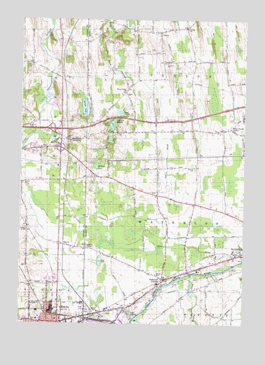
Geneva North, NY USGS Topographic Map
Click on map above to begin viewing in our Map Viewer.

This topographic map contains these locations and features:
Feature Name Type Latitude Longitude GNIS ID View Map
Adsitt FarmsLocaleN42.9819°W76.9864°2558723View Map
Blue Heron Bay MarinaLocaleN42.8885°W76.9232°2617473View Map
Border CityPopulated PlaceN42.8787°W76.9605°944457View Map
Border City Fire Department Serven Fire Company Station 2BuildingN42.8809°W76.9408°2701273View Map
Border City Hose Company Border City Station 1BuildingN42.8792°W76.9610°2700818View Map
Bowdish CemeteryCemeteryN42.9289°W76.9258°2516729View Map
Brown CemeteryCemeteryN42.8989°W76.9880°2542282View Map
Bullhead PondLakeN42.9393°W76.9575°945148View Map
Burnett PondLakeN42.9634°W76.9642°945228View Map
Cottrells FarmLocaleN42.9183°W76.8853°2544113View Map
Dobbin CemeteryCemeteryN42.9073°W76.9631°2516727View Map
Dobbins CornerPopulated PlaceN42.9062°W76.9630°972387View Map
DublinPopulated PlaceN42.9948°W76.9222°948720View Map
East GenevaPopulated PlaceN42.8792°W76.9380°949079View Map
East XLocaleN42.9076°W76.9755°949283View Map
Finger Lakes MarinaLocaleN42.8903°W76.9216°973502View Map
Five PointsPopulated PlaceN42.9490°W76.9783°972478View Map
Gem CreekStreamN42.9006°W76.8780°973602View Map
Gem LakeLakeN42.9007°W76.9562°950979View Map
Geneva General HospitalHospitalN42.8766°W76.9879°2376698View Map
Geneva Industrial ParkLocaleN42.8847°W76.9683°2667555View Map
Geneva Junior High SchoolSchoolN42.8772°W76.9964°2376725View Map
Hoffman CemeteryCemeteryN42.9759°W76.9727°2542283View Map
Hubbard CemeteryCemeteryN42.9393°W76.9033°953350View Map
Humphrey CemeteryCemeteryN42.9475°W76.9858°2542284View Map
Inland HarborHarborN42.8878°W76.9239°973503View Map
Interchange Number 42CrossingN42.9551°W76.9822°974660View Map
Isle of Pines Mobile Home ParkPopulated PlaceN42.8987°W76.9025°2618242View Map
Junius ChurchChurchN42.9962°W76.9072°954361View Map
Junius PondsLakeN42.9569°W76.9489°954362View Map
Junius Ponds CampgroundLocaleN42.9554°W76.9572°2615213View Map
Junius Ponds Westbound Rest AreaLocaleN42.9590°W76.9181°2615116View Map
Junius Volunteer Fire Department Station 1BuildingN42.9955°W76.9209°2700939View Map
Junius Volunteer Fire Department Station 2BuildingN42.9550°W76.9121°2735235View Map
Kendig CreekStreamN42.8953°W76.9025°970261View Map
New York State Police Troop E Zone 2 Waterloo StationBuildingN42.8965°W76.9081°2781138View Map
Newton CemeteryCemeteryN42.9699°W76.9414°958525View Map
North Church (historical)ChurchN42.9189°W76.9636°2106179View Map
North Side Fire CompanyBuildingN42.8898°W76.9943°2700811View Map
North Street Public SchoolSchoolN42.8767°W76.9900°2376726View Map
Packwood CornersPopulated PlaceN42.8931°W76.9191°959734View Map
Parr HarborPopulated PlaceN42.9037°W76.8772°973944View Map
Prospect Avenue SchoolSchoolN42.8767°W76.9794°2376701View Map
Quaker CemeteryCemeteryN42.9296°W76.9225°2106731View Map
Quaker CemeteryCemeteryN42.9302°W76.9217°2516728View Map
Rivers Edge Mobile Home ParkPopulated PlaceN42.8772°W76.9411°2618277View Map
Saint Marys CemeteryCemeteryN42.9049°W76.8773°963903View Map
Saint Patrick's Roman Catholic CemeteryCemeteryN42.8759°W76.9687°2376721View Map
School House Estates Mobile Home ParkPopulated PlaceN42.8978°W76.9053°2618285View Map
School Number 16 (historical)SchoolN42.8889°W76.9022°2106740View Map
School Number 2 (historical)SchoolN42.9278°W76.9261°2106732View Map
School Number 2 (historical)SchoolN42.9528°W76.9036°2106733View Map
School Number 3 (historical)SchoolN42.8975°W76.9025°2106734View Map
School Number 4 (historical)SchoolN42.9825°W76.9200°2106735View Map
School Number 4 (historical)SchoolN42.8953°W76.9239°975359View Map
School Number 5 (historical)SchoolN42.8801°W76.9558°975427View Map
School Number 5 (historical)SchoolN42.9542°W76.9261°2106736View Map
School Number 6 (historical)SchoolN42.9078°W76.9803°2106180View Map
School Number 6 (historical)SchoolN42.9581°W76.8811°2106738View Map
School Number 7 (historical)SchoolN42.9314°W76.9628°2106739View Map
School Number 9 (historical)SchoolN42.9908°W76.9664°2106181View Map
Seneca Drive-In (historical)LocaleN42.8786°W76.9414°2557911View Map
Southwick CemeteryCemeteryN42.9822°W76.9187°965929View Map
Stone Church CornerPopulated PlaceN42.9556°W76.8825°973120View Map
Town of JuniusCivilN42.9799°W76.9096°979112View Map
Town of WaterlooCivilN42.9156°W76.9123°979603View Map
Vandemark CemeteryCemeteryN42.9559°W76.9961°968446View Map
Waterloo WaterworksLocaleN42.9017°W76.8761°2370209View Map
West JuniusPopulated PlaceN42.9506°W76.9736°973241View Map
West Junius ChurchChurchN42.9703°W76.9414°970769View Map

Note: Coordinates in the location and feature list above are referenced to NAD83 datum.


Copyright (C) 2008-2024 Ryan Niemi / Sunset Dynamics ... All Rights Reserved