TopoQuest Logo
Do you find TopoQuest useful?
Help keep TopoQuest running and adding new maps/features by donating!
Bitcoin:  19c7KJd3qBynnjoSw5npx9KScwjBe4ifkT
Litecoin:  LXs6TkuXGGXo1vDsWCkWVdjQX94eUKd6ui
Home View Maps Find Maps Find Places Resources & Links


Union Springs, New York Topographic Map

USGS Map Title: Union Springs, NY
USGS Map MRC: 42076G6
DRG (GeoTIFF) Download: o42076g6.tif


Neighboring USGS Topographic Map Quads:


  Seneca Falls, NY  
42076H7
 

  Cayuga, NY  
42076H6
 

  Auburn, NY  
42076H5
 

  Romulus, NY  
42076G7
 

  Union Springs, NY  
42076G6
 

  Scipio Center, NY  
42076G5
 

  Ovid, NY  
42076F7
 

  Sheldrake, NY  
42076F6
 

  Genoa, NY  
42076F5


Map MRC Location:

N43°
W77°
N43°
W76°
H8 H7 H6 H5 H4 H3 H2 H1
G8 G7 G6 G5 G4 G3 G2 G1
F8 F7 F6 F5 F4 F3 F2 F1
E8 E7 E6 E5 E4 E3 E2 E1
D8 D7 D6 D5 D4 D3 D2 D1
C8 C7 C6 C5 C4 C3 C2 C1
B8 B7 B6 B5 B4 B3 B2 B1
A8 A7 A6 A5 A4 A3 A2 A1
N42°
W77°
N42°
W76°

Union Springs, NY USGS 1:24K Topographic Map Preview:
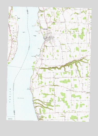
Union Springs, NY USGS Topographic Map
Click on map above to begin viewing in our Map Viewer.

This topographic map contains these locations and features:
Feature Name Type Latitude Longitude GNIS ID View Map
Allens PointCapeN42.8287°W76.7013°942372View Map
Andrew J Smith Elementary SchoolSchoolN42.8367°W76.6885°2597454View Map
AuroraPopulated PlaceN42.7540°W76.7024°942707View Map
Aurora Free LibraryBuildingN42.7539°W76.7021°2598514View Map
Aurora Post OfficePost OfficeN42.7540°W76.7027°2598473View Map
Aurora Volunteer Fire DepartmentBuildingN42.7580°W76.7032°2701308View Map
Barbers CornersLocaleN42.7842°W76.6530°942986View Map
BunkerPopulated PlaceN42.8062°W76.6466°972281View Map
CanogaPopulated PlaceN42.8534°W76.7486°945789View Map
Canoga CreekStreamN42.8648°W76.7361°945790View Map
Canoga IslandIslandN42.8623°W76.7361°945791View Map
Canoga Volunteer Fire DepartmentBuildingN42.8519°W76.7487°2700830View Map
Carrs CoveBayN42.8215°W76.7044°945917View Map
Castelli's MarinaHarborN42.8398°W76.6964°2598500View Map
Cayuga JunctionPopulated PlaceN42.8698°W76.7049°972306View Map
Cayuga Lake FarmLocaleN42.7919°W76.7136°2516775View Map
Cayuga Nation Tribal Designated Statistical AreaCensusN42.7913°W76.7364°2418802View Map
Chestnut Hill CemeteryCemeteryN42.8385°W76.6853°946550View Map
Christadelphian ChapelChurchN42.8513°W76.7477°2615725View Map
Cooneys CornersLocaleN42.7976°W76.6799°947382View Map
Dean CreekStreamN42.7690°W76.7099°948136View Map
Ellis PointCapeN42.7853°W76.7166°949531View Map
Evergreen CemeteryCemeteryN42.7831°W76.6350°949757View Map
FarleysPopulated PlaceN42.8181°W76.6997°949909View Map
Farleys PointCapeN42.8206°W76.7099°949910View Map
Frontenac IslandIslandN42.8434°W76.7074°950757View Map
Frontenac Seventh Day Adventist SchoolSchoolN42.8466°W76.6759°2597193View Map
Gifford CemeteryCemeteryN42.7870°W76.6527°951075View Map
Glen CreekStreamN42.7717°W76.7105°951176View Map
Great GullyValleyN42.8090°W76.7089°951625View Map
Hibiscus Harbor MarinaHarborN42.8568°W76.7068°2598501View Map
Hibiscus PointCapeN42.8548°W76.7097°952677View Map
Hideaway HarborHarborN42.8602°W76.7046°2598502View Map
Howland CemeteryCemeteryN42.7603°W76.6604°953329View Map
Howland PointCapeN42.8481°W76.7055°953334View Map
LevannaPopulated PlaceN42.7845°W76.7136°955230View Map
Oak Glen CemeteryCemeteryN42.7540°W76.6983°959097View Map
Oak Ridge CemeteryCemeteryN42.8584°W76.6791°959155View Map
Old Quaker CemeteryCemeteryN42.7620°W76.6512°959307View Map
Old Quaker CemeteryCemeteryN42.7837°W76.6515°959308View Map
Old Quaker CemeteryCemeteryN42.8114°W76.6658°959309View Map
Old Quaker CemeteryCemeteryN42.8401°W76.6869°959310View Map
Powers CornerPopulated PlaceN42.8595°W76.6644°972967View Map
Richardson CemeteryCemeteryN42.8717°W76.7006°2519236View Map
Saint Michaels CemeteryCemeteryN42.8389°W76.6857°2519237View Map
Saint Micheals ChurchChurchN42.8465°W76.6899°964026View Map
Saint Patricks CemeteryCemeteryN42.7655°W76.7077°964061View Map
Saint Pauls ChurchChurchN42.7515°W76.7011°964119View Map
School Number 1 (historical)SchoolN42.7850°W76.7111°2123354View Map
School Number 10 (historical)SchoolN42.8250°W76.7453°2370174View Map
School Number 2 (historical)SchoolN42.7972°W76.6792°2123355View Map
School Number 3 (historical)SchoolN42.8697°W76.7475°2370172View Map
School Number 4 (historical)SchoolN42.7642°W76.6764°2123356View Map
School Number 4 (historical)SchoolN42.8333°W76.6439°2123357View Map
School Number 5 (historical)SchoolN42.7844°W76.6533°2123358View Map
School Number 7 (historical)SchoolN42.7583°W76.6433°2123359View Map
School Number 9 (historical)SchoolN42.8519°W76.7478°2370173View Map
Southern Springs Mobile Home ParkPopulated PlaceN42.8359°W76.6832°2598490View Map
Springport Free LibraryBuildingN42.8426°W76.6922°2598518View Map
St Bernard FieldAirportN42.8254°W76.6921°978339View Map
Town of SpringportCivilN42.8534°W76.6788°979515View Map
Troy's MarinaHarborN42.8710°W76.7036°2598503View Map
Union CemeteryCemeteryN42.8688°W76.6445°968164View Map
Union Hose and Engine CompanyBuildingN42.8523°W76.6915°2701111View Map
Union SpringsPopulated PlaceN42.8398°W76.6933°968217View Map
Union Springs AcademySchoolN42.8420°W76.6869°968218View Map
Union Springs Middle High SchoolSchoolN42.8503°W76.6923°968219View Map
Union Springs Post OfficePost OfficeN42.8398°W76.6925°2598479View Map
Village of AuroraCivilN42.7512°W76.6994°2391530View Map
Village of Union SpringsCivilN42.8457°W76.6909°2391175View Map
Willis MarinaHarborN42.8227°W76.7028°2598504View Map

Note: Coordinates in the location and feature list above are referenced to NAD83 datum.


Copyright (C) 2008-2024 Ryan Niemi / Sunset Dynamics ... All Rights Reserved