TopoQuest Logo
Do you find TopoQuest useful?
Help keep TopoQuest running and adding new maps/features by donating!
Bitcoin:  19c7KJd3qBynnjoSw5npx9KScwjBe4ifkT
Litecoin:  LXs6TkuXGGXo1vDsWCkWVdjQX94eUKd6ui
Home View Maps Find Maps Find Places Resources & Links


Roosevelt, Utah Topographic Map

USGS Map Title: Roosevelt, UT
USGS Map MRC: 40109C8
DRG (GeoTIFF) Download: o40109c8.tif


Neighboring USGS Topographic Map Quads:


  Neola, UT  
40110D1
 

  Whiterocks, UT  
40109D8
 

  Lapoint, UT  
40109D7
 

  Hancock Cove, UT  
40110C1
 

  Roosevelt, UT  
40109C8
 

  Fort Duchesne, UT  
40109C7
 

  Myton, UT  
40110B1
 

  Windy Ridge, UT  
40109B8
 

  Randlett, UT  
40109B7


Map MRC Location:

N41°
W110°
N41°
W109°
H8 H7 H6 H5 H4 H3 H2 H1
G8 G7 G6 G5 G4 G3 G2 G1
F8 F7 F6 F5 F4 F3 F2 F1
E8 E7 E6 E5 E4 E3 E2 E1
D8 D7 D6 D5 D4 D3 D2 D1
C8 C7 C6 C5 C4 C3 C2 C1
B8 B7 B6 B5 B4 B3 B2 B1
A8 A7 A6 A5 A4 A3 A2 A1
N40°
W110°
N40°
W109°

Roosevelt, UT USGS 1:24K Topographic Map Preview:
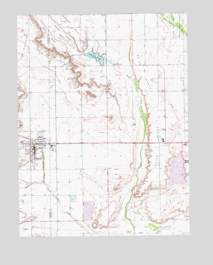
Roosevelt, UT USGS Topographic Map
Click on map above to begin viewing in our Map Viewer.

This topographic map contains these locations and features:
Feature Name Type Latitude Longitude GNIS ID View Map
BallardPopulated PlaceN40.2894°W109.9432°1455969View Map
Bench CanalCanalN40.3602°W109.9068°1425418View Map
BennettPopulated PlaceN40.3738°W109.9354°1437498View Map
Blackhawk LateralCanalN40.3700°W109.9624°1425741View Map
Cobble HollowValleyN40.2552°W109.9538°1426778View Map
Cottonwood CreekStreamN40.2805°W109.9821°1426920View Map
Eagle View Elementary SchoolSchoolN40.3038°W109.8941°1433560View Map
East Elementary SchoolSchoolN40.3056°W109.9816°1435493View Map
Faith Lutheran ChurchChurchN40.3005°W109.9910°1436705View Map
Fort Duchesne Census Designated PlaceCensusN40.2811°W109.8770°2408237View Map
Harding LateralCanalN40.3383°W109.9340°1428523View Map
Indian BenchBenchN40.3211°W109.8993°1428982View Map
Jehovahs Witnesses Roosevelt CongregationChurchN40.2966°W109.9951°1436736View Map
KNEU-AM (Roosevelt)TowerN40.2869°W109.9596°1455742View Map
Lynn Haslem DamDamN40.3466°W109.9290°1434801View Map
Lynn Haslem ReservoirReservoirN40.3466°W109.9290°1434800View Map
Montes CreekStreamN40.2516°W109.9163°1430432View Map
Montes Creek DamDamN40.3500°W109.9340°1434803View Map
Montes Creek ReservoirReservoirN40.3478°W109.9322°1434802View Map
Montes Creek ReservoirReservoirN40.3505°W109.9427°1430433View Map
Montes HollowValleyN40.3525°W109.9538°1430434View Map
Mountainwest Mobile Home CampgroundLocaleN40.2975°W109.9843°1436006View Map
Pickup Wash LateralCanalN40.3016°W109.9554°1431218View Map
RooseveltPopulated PlaceN40.2994°W109.9888°1431989View Map
Roosevelt Christian AssemblyChurchN40.3025°W109.9782°1436758View Map
Roosevelt Fire DepartmentBuildingN40.2957°W109.9912°2627154View Map
Roosevelt Junior High SchoolSchoolN40.2960°W109.9990°1436264View Map
Roosevelt Junior High SchoolSchoolN40.3027°W109.9980°1436265View Map
Roosevelt Memorial ParkCemeteryN40.2883°W109.9993°1436263View Map
Roosevelt Police DepartmentBuildingN40.2959°W109.9910°2730436View Map
Roosevelt Post OfficePost OfficeN40.2985°W109.9867°1455486View Map
Saint Helens Catholic ChurchChurchN40.3019°W109.9854°1436764View Map
State Road LateralCanalN40.2905°W109.9724°1432929View Map
State Road LateralCanalN40.3094°W109.9771°1432930View Map
The Church of Jesus Christ of Latter Day SaintsChurchN40.3063°W109.9807°1450951View Map
The Church of Jesus Christ of Latter Day SaintsChurchN40.3000°W109.9851°1450952View Map
The Church of Jesus Christ of Latter Day SaintsChurchN40.3019°W109.9879°1437043View Map
The Church of Jesus Christ of Latter Day SaintsChurchN40.3022°W109.9690°1436803View Map
Town of BallardCivilN40.2948°W109.9494°2411662View Map
Uintah Basin Medical CenterHospitalN40.3044°W109.9964°1435459View Map
Union High SchoolSchoolN40.3009°W109.9763°1433785View Map
Utah Highway Patrol Section 5 Roosevelt OfficeBuildingN40.2965°W109.9910°2730505View Map
Ute MissionChurchN40.3094°W109.8926°1433849View Map
West Junior High SchoolSchoolN40.3041°W109.8938°1434089View Map

Note: Coordinates in the location and feature list above are referenced to NAD83 datum.


Copyright (C) 2008-2025 Ryan Niemi / Sunset Dynamics ... All Rights Reserved