TopoQuest Logo
Do you find TopoQuest useful?
Help keep TopoQuest running and adding new maps/features by donating!
Bitcoin:  19c7KJd3qBynnjoSw5npx9KScwjBe4ifkT
Litecoin:  LXs6TkuXGGXo1vDsWCkWVdjQX94eUKd6ui
Home View Maps Find Maps Find Places Resources & Links


Lapoint, Utah Topographic Map

USGS Map Title: Lapoint, UT
USGS Map MRC: 40109D7
DRG (GeoTIFF) Download: o40109d7.tif


Neighboring USGS Topographic Map Quads:


  Ice Cave Peak, UT  
40109E8
 

  Lake Mountain, UT  
40109E7
 

  Dry Fork, UT  
40109E6
 

  Whiterocks, UT  
40109D8
 

  Lapoint, UT  
40109D7
 

  Vernal NW, UT  
40109D6
 

  Roosevelt, UT  
40109C8
 

  Fort Duchesne, UT  
40109C7
 

  Vernal SW, UT  
40109C6


Map MRC Location:

N41°
W110°
N41°
W109°
H8 H7 H6 H5 H4 H3 H2 H1
G8 G7 G6 G5 G4 G3 G2 G1
F8 F7 F6 F5 F4 F3 F2 F1
E8 E7 E6 E5 E4 E3 E2 E1
D8 D7 D6 D5 D4 D3 D2 D1
C8 C7 C6 C5 C4 C3 C2 C1
B8 B7 B6 B5 B4 B3 B2 B1
A8 A7 A6 A5 A4 A3 A2 A1
N40°
W110°
N40°
W109°

Lapoint, UT USGS 1:24K Topographic Map Preview:
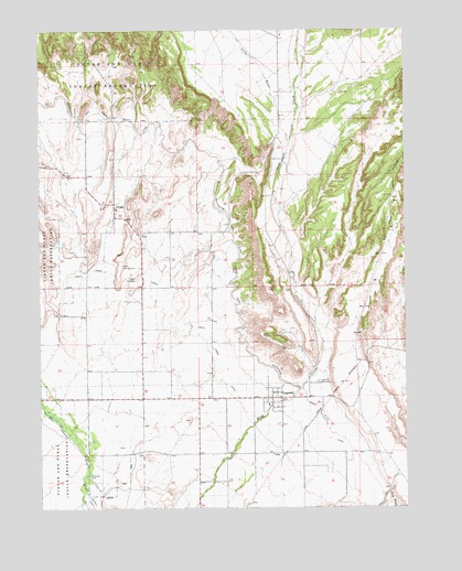
Lapoint, UT USGS Topographic Map
Click on map above to begin viewing in our Map Viewer.

This topographic map contains these locations and features:
Feature Name Type Latitude Longitude GNIS ID View Map
Deep Creek CanalCanalN40.4333°W109.8349°1427295View Map
Diversion DamDamN40.3836°W109.8593°1427418View Map
LapointPopulated PlaceN40.4038°W109.7935°1429476View Map
Lapoint - Tridell Fire DepartmentBuildingN40.4021°W109.7971°2627318View Map
Lapoint CemeteryCemeteryN40.4080°W109.7807°1429477View Map
Lapoint Elementary SchoolSchoolN40.4013°W109.7989°1435844View Map
Lapoint Post OfficePost OfficeN40.4041°W109.7961°2769103View Map
Little WaterStreamN40.4697°W109.7904°1442805View Map
Paradise Air ParkAirportN40.4447°W109.8444°2443209View Map
The Church of Jesus Christ of Latter Day SaintsChurchN40.4036°W109.7932°1436986View Map
The Church of Jesus Christ of Latter Day SaintsChurchN40.4533°W109.8493°1437112View Map
TridellPopulated PlaceN40.4536°W109.8499°1433670View Map
Tridell CemeteryCemeteryN40.4350°W109.8424°1433671View Map
Tridell Post OfficePost OfficeN40.4523°W109.8501°2767358View Map
Uintah Fire District Fire Station - Lapoint - TridellBuildingN40.4040°W109.8156°2768492View Map
Whiterocks and Ouray Valley CanalCanalN40.4688°W109.8193°1434210View Map

Note: Coordinates in the location and feature list above are referenced to NAD83 datum.


Copyright (C) 2008-2025 Ryan Niemi / Sunset Dynamics ... All Rights Reserved