TopoQuest Logo
Do you find TopoQuest useful?
Help keep TopoQuest running and adding new maps/features by donating!
Bitcoin:  19c7KJd3qBynnjoSw5npx9KScwjBe4ifkT
Litecoin:  LXs6TkuXGGXo1vDsWCkWVdjQX94eUKd6ui
Home View Maps Find Maps Find Places Resources & Links


Rosedale, California Topographic Map

USGS Map Title: Rosedale, CA
USGS Map MRC: 35119D2
DRG (GeoTIFF) Download: o35119d2.tif


Neighboring USGS Topographic Map Quads:


  Wasco, CA  
35119E3
 

  Famoso, CA  
35119E2
 

  North of Oildale, CA  
35119E1
 

  Rio Bravo, CA  
35119D3
 

  Rosedale, CA  
35119D2
 

  Oildale, CA  
35119D1
 

  Tupman, CA  
35119C3
 

  Stevens, CA  
35119C2
 

  Gosford, CA  
35119C1


Map MRC Location:

N36°
W120°
N36°
W119°
H8 H7 H6 H5 H4 H3 H2 H1
G8 G7 G6 G5 G4 G3 G2 G1
F8 F7 F6 F5 F4 F3 F2 F1
E8 E7 E6 E5 E4 E3 E2 E1
D8 D7 D6 D5 D4 D3 D2 D1
C8 C7 C6 C5 C4 C3 C2 C1
B8 B7 B6 B5 B4 B3 B2 B1
A8 A7 A6 A5 A4 A3 A2 A1
N35°
W120°
N35°
W119°

Rosedale, CA USGS 1:24K Topographic Map Preview:
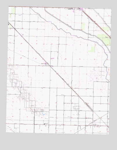
Rosedale, CA USGS Topographic Map
Click on map above to begin viewing in our Map Viewer.

This topographic map contains these locations and features:
Feature Name Type Latitude Longitude GNIS ID View Map
Arkelo RanchLocaleN35.4658°W119.1454°1682817View Map
CaweloPopulated PlaceN35.4994°W119.1657°1660451View Map
Centennial Elementary SchoolSchoolN35.3863°W119.1459°1836040View Map
City of ShafterCivilN35.4780°W119.1992°2411873View Map
CromePopulated PlaceN35.4416°W119.2001°1660524View Map
Greeley Oil FieldOilfieldN35.4063°W119.2290°277379View Map
Greeley SchoolSchoolN35.3838°W119.2046°242980View Map
Hights CornerPopulated PlaceN35.4433°W119.2023°1660749View Map
KKBB-FM (Shafter)TowerN35.4194°W119.1993°1663097View Map
KXHA-FM (Shafter)TowerN35.4194°W119.1993°1663096View Map
LerdoPopulated PlaceN35.4902°W119.1526°1660907View Map
Lerdo Primary SchoolSchoolN35.4991°W119.1748°244750View Map
Palm School (historical)SchoolN35.4052°W119.1807°1662043View Map
ProsperoPopulated PlaceN35.4711°W119.1268°1661260View Map
RosedalePopulated PlaceN35.3836°W119.1454°1652784View Map
Rosedale Census Designated PlaceCensusN35.3887°W119.2054°2409211View Map
Rosedale DivisionCivilN35.3967°W119.1761°1935270View Map
Rosedale Middle SchoolSchoolN35.3826°W119.1407°1836055View Map
Rosedale North Elementary SchoolSchoolN35.3914°W119.1298°1836056View Map
Rosedale Oil FieldOilfieldN35.3969°W119.1659°277413View Map
Rosedale School District OfficeBuildingN35.3827°W119.1390°1836057View Map
Rosedale Station (historical)LocaleN35.4033°W119.1515°1662057View Map
Shafter CemeteryCemeteryN35.4727°W119.2351°249336View Map
UnaPopulated PlaceN35.4244°W119.1779°1661599View Map
Una Siding (historical)LocaleN35.4522°W119.2121°1662068View Map
White ChurchChurchN35.3836°W119.1801°1662072View Map

Note: Coordinates in the location and feature list above are referenced to NAD83 datum.


Copyright (C) 2008-2024 Ryan Niemi / Sunset Dynamics ... All Rights Reserved