TopoQuest Logo
Do you find TopoQuest useful?
Help keep TopoQuest running and adding new maps/features by donating!
Bitcoin:  19c7KJd3qBynnjoSw5npx9KScwjBe4ifkT
Litecoin:  LXs6TkuXGGXo1vDsWCkWVdjQX94eUKd6ui
Home View Maps Find Maps Find Places Resources & Links


Rosetta, Arkansas Topographic Map

USGS Map Title: Rosetta, AR
USGS Map MRC: 35093F3
DRG (GeoTIFF) Download: o35093f3.tif


Neighboring USGS Topographic Map Quads:


  Fallsville, AR  
35093G4
 

  Swain, AR  
35093G3
 

  Deer, AR  
35093G2
 

  Ozone, AR  
35093F4
 

  Rosetta, AR  
35093F3
 

  Fort Douglas, AR  
35093F2
 

  Ludwig, AR  
35093E4
 

  Hagarville, AR  
35093E3
 

  Treat, AR  
35093E2


Map MRC Location:

N36°
W94°
N36°
W93°
H8 H7 H6 H5 H4 H3 H2 H1
G8 G7 G6 G5 G4 G3 G2 G1
F8 F7 F6 F5 F4 F3 F2 F1
E8 E7 E6 E5 E4 E3 E2 E1
D8 D7 D6 D5 D4 D3 D2 D1
C8 C7 C6 C5 C4 C3 C2 C1
B8 B7 B6 B5 B4 B3 B2 B1
A8 A7 A6 A5 A4 A3 A2 A1
N35°
W94°
N35°
W93°

Rosetta, AR USGS 1:24K Topographic Map Preview:
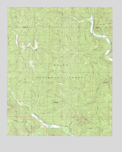
Rosetta, AR USGS Topographic Map
Click on map above to begin viewing in our Map Viewer.

This topographic map contains these locations and features:
Feature Name Type Latitude Longitude GNIS ID View Map
Bee RidgeRidgeN35.6967°W93.3649°70608View Map
Bluff Spring SchoolSchoolN35.7040°W93.2566°70740View Map
Boston MountainsRangeN35.7123°W93.3418°70773View Map
Bowman HollowValleyN35.6595°W93.2710°59141View Map
Cedar CreekStreamN35.6462°W93.3441°71067View Map
Childers HollowValleyN35.6845°W93.2724°71137View Map
Cow CreekStreamN35.7373°W93.2741°71254View Map
Dry CreekStreamN35.6459°W93.3418°74277View Map
Flint StoreLocaleN35.6487°W93.3452°71640View Map
GarberPopulated PlaceN35.6651°W93.3677°71727View Map
Gee CreekStreamN35.6784°W93.2618°71744View Map
Haw Creek Falls Recreation AreaParkN35.6765°W93.2555°59144View Map
Hess KnobSummitN35.6406°W93.2852°71981View Map
Jims RidgeRidgeN35.7192°W93.3013°72192View Map
Lick CreekStreamN35.6704°W93.3724°72334View Map
Little Cow CreekStreamN35.7351°W93.2891°72382View Map
Looper HollowValleyN35.7101°W93.2549°72489View Map
Middle Cow CreekStreamN35.7412°W93.3071°72633View Map
Middle RidgeRidgeN35.7292°W93.3213°72642View Map
Mineral Springs Recreation AreaParkN35.6579°W93.3207°59150View Map
Mount LeviLocaleN35.6351°W93.3143°72753View Map
Murray CreekStreamN35.6379°W93.3324°72822View Map
Ozark National ForestForestN35.7068°W93.3492°79166View Map
Pilot Rock MountainSummitN35.6334°W93.2546°67137View Map
Pine RidgeRidgeN35.7215°W93.2846°73098View Map
Rich KnobSummitN35.6704°W93.2888°73287View Map
Rock CreekStreamN35.7404°W93.2743°73343View Map
RosettaPopulated PlaceN35.7090°W93.3446°73382View Map
Rosetta CemeteryCemeteryN35.7112°W93.3546°77485View Map
Tow PointCapeN35.7454°W93.3657°73883View Map
Township of Piney (historical)CivilN35.6390°W93.3043°66765View Map
Turkey HollowValleyN35.6442°W93.3385°59158View Map
Union CemeteryCemeteryN35.6345°W93.3321°59160View Map
Union SchoolSchoolN35.6345°W93.3296°73945View Map
Walnut RidgeRidgeN35.6973°W93.2682°74001View Map

Note: Coordinates in the location and feature list above are referenced to NAD83 datum.


Copyright (C) 2008-2024 Ryan Niemi / Sunset Dynamics ... All Rights Reserved