TopoQuest Logo
Do you find TopoQuest useful?
Help keep TopoQuest running and adding new maps/features by donating!
Bitcoin:  19c7KJd3qBynnjoSw5npx9KScwjBe4ifkT
Litecoin:  LXs6TkuXGGXo1vDsWCkWVdjQX94eUKd6ui
Home View Maps Find Maps Find Places Resources & Links


Swain, Arkansas Topographic Map

USGS Map Title: Swain, AR
USGS Map MRC: 35093G3
DRG (GeoTIFF) Download: o35093g3.tif


Neighboring USGS Topographic Map Quads:


  Boxley, AR  
35093H4
 

  Murray, AR  
35093H3
 

  Parthenon, AR  
35093H2
 

  Fallsville, AR  
35093G4
 

  Swain, AR  
35093G3
 

  Deer, AR  
35093G2
 

  Ozone, AR  
35093F4
 

  Rosetta, AR  
35093F3
 

  Fort Douglas, AR  
35093F2


Map MRC Location:

N36°
W94°
N36°
W93°
H8 H7 H6 H5 H4 H3 H2 H1
G8 G7 G6 G5 G4 G3 G2 G1
F8 F7 F6 F5 F4 F3 F2 F1
E8 E7 E6 E5 E4 E3 E2 E1
D8 D7 D6 D5 D4 D3 D2 D1
C8 C7 C6 C5 C4 C3 C2 C1
B8 B7 B6 B5 B4 B3 B2 B1
A8 A7 A6 A5 A4 A3 A2 A1
N35°
W94°
N35°
W93°

Swain, AR USGS 1:24K Topographic Map Preview:
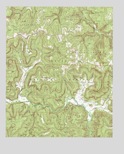
Swain, AR USGS Topographic Map
Click on map above to begin viewing in our Map Viewer.

This topographic map contains these locations and features:
Feature Name Type Latitude Longitude GNIS ID View Map
Barberry CreekStreamN35.8476°W93.2557°70505View Map
Bear CreekStreamN35.7804°W93.3427°76267View Map
Beckham HollowValleyN35.7881°W93.3510°70594View Map
Bee Run HollowValleyN35.7809°W93.2960°70610View Map
Buckner HollowValleyN35.8654°W93.2838°70905View Map
Casey CemeteryCemeteryN35.7831°W93.3021°71027View Map
Clayburn CemeteryCemeteryN35.7973°W93.2513°71156View Map
Clayburn PointSummitN35.8126°W93.3688°71157View Map
Cole CreekStreamN35.8131°W93.3516°71194View Map
Cooley CreekStreamN35.8273°W93.3618°71214View Map
Coon HollowValleyN35.8642°W93.3141°71217View Map
County Line KnobSummitN35.7548°W93.3074°71242View Map
Culbertson PointSummitN35.8320°W93.3502°71314View Map
Curtis CemeteryCemeteryN35.7870°W93.2568°74501View Map
Curtis CreekStreamN35.7695°W93.2746°71322View Map
Dismal CreekStreamN35.7990°W93.3588°71390View Map
Dismal HollowValleyN35.8506°W93.2702°71391View Map
Dog BranchStreamN35.8509°W93.2655°71399View Map
East BranchStreamN35.8009°W93.2827°71493View Map
East Cole CreekStreamN35.8273°W93.3621°71496View Map
Edwards JunctionPopulated PlaceN35.8484°W93.3613°71536View Map
Essex CemeteryCemeteryN35.7787°W93.2593°71566View Map
Flat Rock CreekStreamN35.7795°W93.3291°71626View Map
Gillian RidgeRidgeN35.7690°W93.3321°71754View Map
Gladon CreekStreamN35.8492°W93.2638°71763View Map
Gobblers KnobSummitN35.7673°W93.3724°71776View Map
Hickory Grove CemeteryCemeteryN35.8234°W93.2879°71990View Map
Home CreekStreamN35.7790°W93.2818°72053View Map
Lee HollowValleyN35.8676°W93.2860°72302View Map
LimestonePopulated PlaceN35.7840°W93.2835°72355View Map
Little Round MountainSummitN35.8065°W93.3349°72420View Map
Lone Hill CemeteryCemeteryN35.7809°W93.2752°72456View Map
Lost MountainSummitN35.8612°W93.3516°72495View Map
NailPopulated PlaceN35.8245°W93.2930°72828View Map
Nail Post OfficePost OfficeN35.8251°W93.2932°84503View Map
Ode HollowValleyN35.7737°W93.3160°72918View Map
Ogden CemeteryCemeteryN35.7845°W93.2674°72921View Map
Owl HollowValleyN35.8023°W93.2863°72970View Map
Paxton KnobSummitN35.8401°W93.2763°73021View Map
Pilot Knob RidgeRidgeN35.7942°W93.2724°73080View Map
Possum Trot HollowValleyN35.8295°W93.3335°73169View Map
Red Lick HollowValleyN35.7895°W93.3018°73255View Map
Reeves PointCapeN35.7631°W93.2599°73274View Map
Spradley HollowValleyN35.7837°W93.3060°73670View Map
Steel CreekStreamN35.7790°W93.2643°73692View Map
Stone RidgeRidgeN35.7701°W93.2891°73726View Map
SwainPopulated PlaceN35.8492°W93.3399°73793View Map
Township of Hickory GroveCivilN35.8319°W93.2826°69676View Map
Township of JeffersonCivilN35.8177°W93.3665°69679View Map
Township of Walnut (historical)CivilN35.7751°W93.3710°69695View Map
Turkey TrailTrailN35.7509°W93.3588°73910View Map
Union Grove CemeteryCemeteryN35.8659°W93.3016°73939View Map
WalnutPopulated PlaceN35.7906°W93.3593°78677View Map
Walnut CreekStreamN35.7840°W93.3602°73995View Map
Watson HollowValleyN35.8673°W93.3132°74023View Map
Willis BranchStreamN35.8684°W93.2849°74168View Map

Note: Coordinates in the location and feature list above are referenced to NAD83 datum.


Copyright (C) 2008-2024 Ryan Niemi / Sunset Dynamics ... All Rights Reserved