TopoQuest Logo
Do you find TopoQuest useful?
Help keep TopoQuest running and adding new maps/features by donating!
Bitcoin:  19c7KJd3qBynnjoSw5npx9KScwjBe4ifkT
Litecoin:  LXs6TkuXGGXo1vDsWCkWVdjQX94eUKd6ui
Home View Maps Find Maps Find Places Resources & Links


Round Prairie, Minnesota Topographic Map

USGS Map Title: Round Prairie, MN
USGS Map MRC: 45094H8
DRG (GeoTIFF) Download: o45094h8.tif


Neighboring USGS Topographic Map Quads:


  Clotho, MN  
46095A1
 

  Browerville SW, MN  
46094A8
 

  Browerville, MN  
46094A7
 

  Lake Osakis East, MN  
45095H1
 

  Round Prairie, MN  
45094H8
 

  Long Prairie, MN  
45094H7
 

  West Union, MN  
45095G1
 

  Sauk Lake, MN  
45094G8
 

  Ward Springs, MN  
45094G7


Map MRC Location:

N46°
W95°
N46°
W94°
H8 H7 H6 H5 H4 H3 H2 H1
G8 G7 G6 G5 G4 G3 G2 G1
F8 F7 F6 F5 F4 F3 F2 F1
E8 E7 E6 E5 E4 E3 E2 E1
D8 D7 D6 D5 D4 D3 D2 D1
C8 C7 C6 C5 C4 C3 C2 C1
B8 B7 B6 B5 B4 B3 B2 B1
A8 A7 A6 A5 A4 A3 A2 A1
N45°
W95°
N45°
W94°

Round Prairie, MN USGS 1:24K Topographic Map Preview:
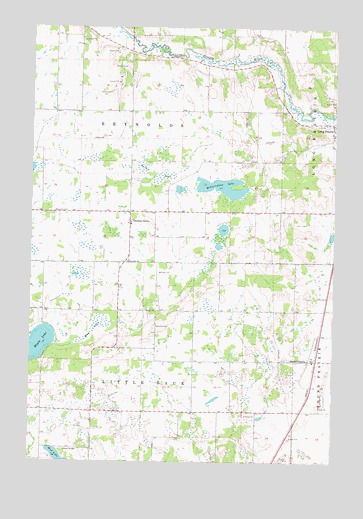
Round Prairie, MN USGS Topographic Map
Click on map above to begin viewing in our Map Viewer.

This topographic map contains these locations and features:
Feature Name Type Latitude Longitude GNIS ID View Map
Gutches GrovePopulated PlaceN45.9441°W94.9595°644544View Map
H Groschel PondReservoirN45.8764°W94.9131°1776363View Map
Keller LakeSwampN45.9580°W94.9484°646067View Map
Kootenai Christian Mennonite ChurchChurchN45.9042°W94.8806°2068851View Map
McCarrahan LakeLakeN45.9542°W94.9215°647652View Map
Mud LakeSwampN45.9130°W94.9742°648345View Map
Mud LakeLakeN45.8760°W94.9870°648352View Map
Reynolds CemeteryCemeteryN45.9141°W94.9492°649953View Map
Reynolds CemeteryCemeteryN45.9463°W94.9903°649954View Map
Reynolds ChurchChurchN45.9327°W94.9600°649955View Map
Round PrairiePopulated PlaceN45.9044°W94.8856°650365View Map
Round Prairie (historical)LocaleN45.9047°W94.8822°2068957View Map
Round Prairie Community ChurchChurchN45.9075°W94.8847°2068880View Map
Round Prairie Post Office (historical)Post OfficeN45.9044°W94.8853°2068958View Map
Saint John Vianney ChurchChurchN45.9042°W94.8806°2068852View Map
School Number 2283SchoolN45.8783°W94.9850°651567View Map
Township of Little SaukCivilN45.8894°W94.9534°664807View Map
Township of ReynoldsCivilN45.9760°W94.9597°665402View Map

Note: Coordinates in the location and feature list above are referenced to NAD83 datum.


Copyright (C) 2008-2024 Ryan Niemi / Sunset Dynamics ... All Rights Reserved