TopoQuest Logo
Do you find TopoQuest useful?
Help keep TopoQuest running and adding new maps/features by donating!
Bitcoin:  19c7KJd3qBynnjoSw5npx9KScwjBe4ifkT
Litecoin:  LXs6TkuXGGXo1vDsWCkWVdjQX94eUKd6ui
Home View Maps Find Maps Find Places Resources & Links


Ward Springs, Minnesota Topographic Map

USGS Map Title: Ward Springs, MN
USGS Map MRC: 45094G7
DRG (GeoTIFF) Download: o45094g7.tif


Neighboring USGS Topographic Map Quads:


  Round Prairie, MN  
45094H8
 

  Long Prairie, MN  
45094H7
 

  Swanville, MN  
45094H6
 

  Sauk Lake, MN  
45094G8
 

  Ward Springs, MN  
45094G7
 

  Burtrum, MN  
45094G6
 

  Sauk Centre, MN  
45094F8
 

  Melrose, MN  
45094F7
 

  Freeport, MN  
45094F6


Map MRC Location:

N46°
W95°
N46°
W94°
H8 H7 H6 H5 H4 H3 H2 H1
G8 G7 G6 G5 G4 G3 G2 G1
F8 F7 F6 F5 F4 F3 F2 F1
E8 E7 E6 E5 E4 E3 E2 E1
D8 D7 D6 D5 D4 D3 D2 D1
C8 C7 C6 C5 C4 C3 C2 C1
B8 B7 B6 B5 B4 B3 B2 B1
A8 A7 A6 A5 A4 A3 A2 A1
N45°
W95°
N45°
W94°

Ward Springs, MN USGS 1:24K Topographic Map Preview:
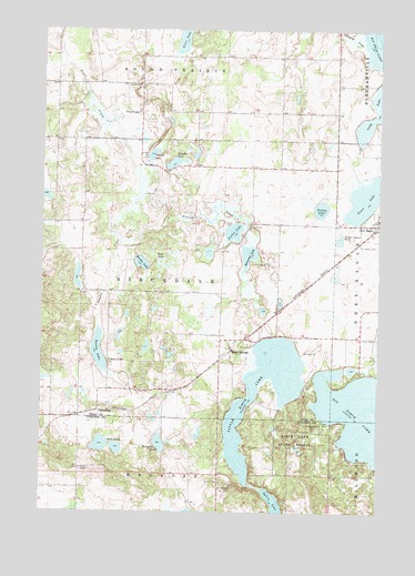
Ward Springs, MN USGS Topographic Map
Click on map above to begin viewing in our Map Viewer.

This topographic map contains these locations and features:
Feature Name Type Latitude Longitude GNIS ID View Map
Big Birch LakeReservoirN45.7833°W94.7736°1775885View Map
Big Birch Lake DamDamN45.7833°W94.7736°1775884View Map
Birch Lakes State ForestParkN45.7655°W94.7700°640180View Map
Bunker LakeLakeN45.8145°W94.8382°640647View Map
D Peschel PondReservoirN45.8299°W94.8300°1776371View Map
D Peschel Pond DamDamN45.8283°W94.8253°1776370View Map
Feucht LakeLakeN45.8426°W94.8345°643617View Map
Fuller LakeLakeN45.8227°W94.8043°643989View Map
Grey Eagle (historical)LocaleN45.8233°W94.7522°2068882View Map
Hartnette LakeLakeN45.7678°W94.8311°644709View Map
Hennessy LakeLakeN45.8152°W94.7987°644878View Map
Lady LakeLakeN45.8517°W94.7528°646309View Map
Little Birch LakeLakeN45.7899°W94.7921°646763View Map
Pauley LakeLakeN45.7914°W94.8537°649187View Map
Pixley LakeLakeN45.8287°W94.7719°649535View Map
Prairie CreekStreamN45.7944°W94.7947°649701View Map
Saint Joseph CemeteryCemeteryN45.8194°W94.7575°650757View Map
Saint Joseph's Catholic ChurchChurchN45.8261°W94.7506°2068883View Map
Schafer LakeLakeN45.8406°W94.8260°651276View Map
School Number 2260SchoolN45.8750°W94.8742°651558View Map
School Number 2269SchoolN45.7891°W94.8497°651561View Map
School Number 2275SchoolN45.8533°W94.8397°651563View Map
Schwanke CreekStreamN45.8714°W94.7567°651794View Map
SpauldingPopulated PlaceN45.7761°W94.8528°654953View Map
Stub LakesLakeN45.7673°W94.8503°652738View Map
Sylvia LakeReservoirN45.7511°W94.7881°652968View Map
Township of BirchdaleCivilN45.8080°W94.8430°663596View Map
Trace LakeLakeN45.8314°W94.7554°653260View Map
Trout CreekStreamN45.8325°W94.8370°653346View Map
Ward SpringsPopulated PlaceN45.7919°W94.8050°653777View Map
Ward Springs (historical)LocaleN45.7914°W94.8083°2068979View Map
Ward Springs Post Office (historical)Post OfficeN45.7919°W94.8047°2068980View Map
Zager LakeLakeN45.8141°W94.8310°654432View Map

Note: Coordinates in the location and feature list above are referenced to NAD83 datum.


Copyright (C) 2008-2024 Ryan Niemi / Sunset Dynamics ... All Rights Reserved