TopoQuest Logo
Do you find TopoQuest useful?
Help keep TopoQuest running and adding new maps/features by donating!
Bitcoin:  19c7KJd3qBynnjoSw5npx9KScwjBe4ifkT
Litecoin:  LXs6TkuXGGXo1vDsWCkWVdjQX94eUKd6ui
Home View Maps Find Maps Find Places Resources & Links


Sauk Lake, Minnesota Topographic Map

USGS Map Title: Sauk Lake, MN
USGS Map MRC: 45094G8
DRG (GeoTIFF) Download: o45094g8.tif


Neighboring USGS Topographic Map Quads:


  Lake Osakis East, MN  
45095H1
 

  Round Prairie, MN  
45094H8
 

  Long Prairie, MN  
45094H7
 

  West Union, MN  
45095G1
 

  Sauk Lake, MN  
45094G8
 

  Ward Springs, MN  
45094G7
 

  Raymond Lake, MN  
45095F1
 

  Sauk Centre, MN  
45094F8
 

  Melrose, MN  
45094F7


Map MRC Location:

N46°
W95°
N46°
W94°
H8 H7 H6 H5 H4 H3 H2 H1
G8 G7 G6 G5 G4 G3 G2 G1
F8 F7 F6 F5 F4 F3 F2 F1
E8 E7 E6 E5 E4 E3 E2 E1
D8 D7 D6 D5 D4 D3 D2 D1
C8 C7 C6 C5 C4 C3 C2 C1
B8 B7 B6 B5 B4 B3 B2 B1
A8 A7 A6 A5 A4 A3 A2 A1
N45°
W95°
N45°
W94°

Sauk Lake, MN USGS 1:24K Topographic Map Preview:
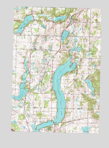
Sauk Lake, MN USGS Topographic Map
Click on map above to begin viewing in our Map Viewer.

This topographic map contains these locations and features:
Feature Name Type Latitude Longitude GNIS ID View Map
Ashley CreekStreamN45.7569°W94.9661°639474View Map
Berscheid Structure DamDamN45.8350°W94.9053°1777205View Map
Bethel CemeteryCemeteryN45.8658°W94.9722°2068841View Map
Bethel ChurchChurchN45.8655°W94.9728°640027View Map
Big Sauk Lake Mobile Home ParkPopulated PlaceN45.7583°W94.9292°2069182View Map
Cedar LakeLakeN45.8471°W94.9270°641014View Map
Cedar LakeLakeN45.7514°W94.8963°641025View Map
Cedar Lake Wayside ParkParkN45.8417°W94.9311°2068951View Map
Cedar Lake Wayside ParkParkN45.8528°W94.9264°2068952View Map
Deer LakeLakeN45.8156°W94.8846°642718View Map
Fairy LakeLakeN45.7894°W94.9860°643526View Map
H Groschel Pond DamDamN45.8750°W94.9120°1776362View Map
Juergens LakeLakeN45.8641°W94.9341°646010View Map
Kandota CemeteryCemeteryN45.8319°W94.9678°646034View Map
Lily LakeLakeN45.8029°W94.9828°646647View Map
Lions ParkParkN45.7828°W94.9861°2068817View Map
Little SaukPopulated PlaceN45.8639°W94.9184°646925View Map
Little Sauk (historical)LocaleN45.8644°W94.9181°2068968View Map
Little Sauk CemeteryCemeteryN45.8583°W94.9736°2068840View Map
Little Sauk ChurchChurchN45.8583°W94.9736°646926View Map
Little Sauk LakeLakeN45.8580°W94.9842°646927View Map
Little Sauk Post OfficePost OfficeN45.8639°W94.9181°2068967View Map
Long LakeLakeN45.7985°W94.8894°647067View Map
Long LakeLakeN45.8135°W94.9804°647068View Map
Minnesota Home CemeteryCemeteryN45.7514°W94.9208°2068089View Map
Minnesota Home SchoolSchoolN45.7508°W94.9470°647937View Map
Mud LakeLakeN45.8336°W94.9137°648263View Map
Sauk LakeReservoirN45.7851°W94.9357°651234View Map
Sauk Lake Wayside ParkParkN45.7583°W94.9361°2068379View Map
Saukinac CampgroundLocaleN45.8250°W94.9167°2068816View Map
School Number 2281SchoolN45.8027°W94.9111°651565View Map
School Number 2300SchoolN45.8322°W94.9667°651574View Map
Spier LakeLakeN45.8292°W94.8923°652388View Map
Svealund CemeteryCemeteryN45.8403°W94.9236°2068843View Map
Township of KandotaCivilN45.8139°W94.9644°664598View Map
Twin Island LakeLakeN45.8558°W94.9575°653412View Map
Twin LakeLakeN45.7772°W94.9036°653424View Map

Note: Coordinates in the location and feature list above are referenced to NAD83 datum.


Copyright (C) 2008-2025 Ryan Niemi / Sunset Dynamics ... All Rights Reserved