TopoQuest Logo
Do you find TopoQuest useful?
Help keep TopoQuest running and adding new maps/features by donating!
Bitcoin:  19c7KJd3qBynnjoSw5npx9KScwjBe4ifkT
Litecoin:  LXs6TkuXGGXo1vDsWCkWVdjQX94eUKd6ui
Home View Maps Find Maps Find Places Resources & Links


Ruby, Arizona Topographic Map

USGS Map Title: Ruby, AZ
USGS Map MRC: 31111D2
DRG (GeoTIFF) Download: o31111d2.tif


Neighboring USGS Topographic Map Quads:


  Arivaca, AZ  
31111E3
 

  Murphy Peak, AZ  
31111E2
 

  Tubac, AZ  
31111E1
 

  Bartlett Mountain, AZ  
31111D3
 

  Ruby, AZ  
31111D2
 

  Pena Blanca Lake, AZ  
31111D1


  Alamo Spring, AZ  
31111C2
 

  Pajarito Peak, AZ  
31111C1


Map MRC Location:

N32°
W112°
N32°
W111°
H8 H7 H6 H5 H4 H3 H2 H1
G8 G7 G6 G5 G4 G3 G2 G1
F8 F7 F6 F5 F4 F3 F2 F1
E8 E7 E6 E5 E4 E3 E2 E1
D8 D7 D6 D5 D4 D3 D2 D1
C8 C7 C6 C5 C4 C3 C2 C1
B8 B7 B6 B5 B4 B3 B2 B1
A8 A7 A6 A5 A4 A3 A2 A1
N31°
W112°
N31°
W111°

Ruby, AZ USGS 1:24K Topographic Map Preview:
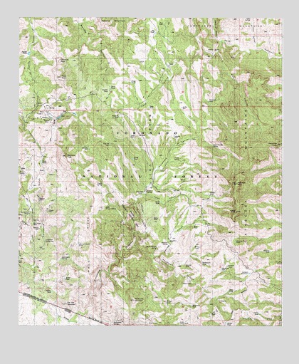
Ruby, AZ USGS Topographic Map
Click on map above to begin viewing in our Map Viewer.

This topographic map contains these locations and features:
Feature Name Type Latitude Longitude GNIS ID View Map
Agua Cereado SpringSpringN31.4484°W111.1595°25539View Map
Alto Schumaker TankReservoirN31.4087°W111.2218°36520View Map
Amada TankReservoirN31.3759°W111.1517°25613View Map
Apache DamsDamN31.4265°W111.2398°36526View Map
Atascosa CanyonValleyN31.4026°W111.1868°25833View Map
Atascosa Lookout Number One HundredLocaleN31.4215°W111.1468°36531View Map
Atascosa MountainsSummitN31.4326°W111.1468°25834View Map
Atascosa PeakSummitN31.4326°W111.1476°25835View Map
Atascosa SpringSpringN31.4084°W111.1793°25836View Map
Atascosa Trail TankReservoirN31.4093°W111.1476°36532View Map
Bear ValleyBasinN31.4343°W111.1815°26129View Map
Bear Valley RanchLocaleN31.4101°W111.1790°26131View Map
Beehive CanyonValleyN31.4904°W111.1565°26182View Map
Big TankReservoirN31.4944°W111.1859°36552View Map
Black TankReservoirN31.4189°W111.1866°36553View Map
Bolsa TankReservoirN31.4717°W111.2067°36555View Map
Border TankReservoirN31.3942°W111.2281°36558View Map
Bos Arnegos MineMineN31.4204°W111.2454°26625View Map
Boulder TankReservoirN31.4705°W111.2077°43107View Map
Broken TankReservoirN31.4820°W111.1909°36561View Map
California MineMineN31.4145°W111.2404°36574View Map
California SpringSpringN31.4098°W111.2376°27179View Map
Casito SpringSpringN31.4420°W111.1748°27327View Map
Chiminea PeakSummitN31.4826°W111.2315°27587View Map
Corral NuevoLocaleN31.4809°W111.1795°27977View Map
Cramer MineMineN31.4215°W111.2362°36599View Map
Dos Amigos MineMineN31.4168°W111.2429°36612View Map
Dry TankReservoirN31.3802°W111.1567°36616View Map
Flat Top MountainSummitN31.3840°W111.2273°36629View Map
Footes SpringSpringN31.4381°W111.2493°36632View Map
Frog TankReservoirN31.4736°W111.1969°36635View Map
Gooding Research Natural AreaParkN31.4218°W111.1954°36640View Map
Granite DamDamN31.4398°W111.2118°36644View Map
Granite TankReservoirN31.3996°W111.1714°36645View Map
Gray WellWellN31.4237°W111.1615°36646View Map
Hells GateGapN31.4862°W111.1570°29864View Map
Hidden TankReservoirN31.3890°W111.2341°36657View Map
Highway DamDamN31.4340°W111.1709°36659View Map
Hillside SpringSpringN31.4101°W111.1368°36660View Map
Horse Pasture SpringSpringN31.4070°W111.1848°36661View Map
Jackie DamDamN31.4518°W111.1973°36664View Map
Javilina DamDamN31.4637°W111.1729°36670View Map
Leon CanyonValleyN31.4873°W111.1354°31013View Map
Leon SpringSpringN31.4998°W111.1407°36687View Map
Little Tinaja SpringSpringN31.4232°W111.2090°36694View Map
Little Tonto TankReservoirN31.3763°W111.1739°36695View Map
Lookout TankReservoirN31.3994°W111.1514°36698View Map
Manzanita MountainSummitN31.3862°W111.1965°31493View Map
Manzanita SpringSpringN31.3754°W111.2048°31494View Map
Marmee MineMineN31.3926°W111.1415°36715View Map
Mesa TankReservoirN31.4069°W111.1646°36718View Map
Mesa TankReservoirN31.4157°W111.1675°36719View Map
Midway DamDamN31.4515°W111.1765°36725View Map
Montana DamDamN31.4465°W111.2170°36731View Map
Montana MineMineN31.4587°W111.2382°36732View Map
Montana PeakSummitN31.4434°W111.2279°31960View Map
Montoya TankReservoirN31.4052°W111.1311°36735View Map
Monument TankReservoirN31.3832°W111.1684°36737View Map
Mule RidgeRidgeN31.4268°W111.2190°32171View Map
Nogales Ranger DistrictForestN31.4695°W111.1937°2038586View Map
Oak TankReservoirN31.4974°W111.1818°36756View Map
Old GloryLocaleN31.4365°W111.2443°45619View Map
Old Glory CanyonValleyN31.4151°W111.2459°32502View Map
Oro Blanco MineMineN31.4207°W111.2451°36759View Map
Pajarita WildernessReserveN31.3945°W111.1913°44998View Map
Papago TanksReservoirN31.4853°W111.2455°36767View Map
Peņasco CanyonValleyN31.4062°W111.1956°32782View Map
Peņasco DamDamN31.3843°W111.1679°36780View Map
Pine CanyonValleyN31.4904°W111.1565°32918View Map
Ramanote Canyon Natural ArchArchN31.4414°W111.1375°2629412View Map
Ramanote PeakSummitN31.4484°W111.1287°33347View Map
Range Line DamDamN31.3982°W111.1540°36796View Map
Rattlesnake TankReservoirN31.4006°W111.1635°36798View Map
Red Bluffs DamDamN31.4765°W111.1706°36799View Map
Red Rock TankReservoirN31.4945°W111.1665°36801View Map
Ridge TankReservoirN31.3895°W111.1508°36808View Map
Roadside TankReservoirN31.4598°W111.2026°36813View Map
RubyPopulated PlaceN31.4612°W111.2376°33856View Map
Ruby LakesLakeN31.4413°W111.2393°36822View Map
Ruby PeakSummitN31.4756°W111.2304°33857View Map
Ruby TankReservoirN31.4706°W111.2069°33858View Map
Ruby Trail DamDamN31.4490°W111.2081°36823View Map
Saddle TankReservoirN31.4281°W111.1600°36827View Map
Salty TankReservoirN31.4636°W111.1886°36828View Map
Sandy TankReservoirN31.4428°W111.1963°36830View Map
Savoita SpringSpringN31.4723°W111.2340°36836View Map
Schumaker SpringSpringN31.4026°W111.2298°36840View Map
Scribner GulchValleyN31.3982°W111.2479°34175View Map
Summit Motorway 39ATrailN31.3815°W111.1487°36856View Map
Summit ReservoirReservoirN31.3964°W111.1411°34945View Map
Thumb ButteSummitN31.4001°W111.1284°35305View Map
Tinaja SpringSpringN31.4329°W111.2104°36868View Map
Tinker TankReservoirN31.3802°W111.1364°36870View Map
Tonto CanyonValleyN31.3782°W111.2168°35374View Map
Tres Amigos GulchValleyN31.4157°W111.2479°35460View Map
Warsaw CanyonValleyN31.4029°W111.2423°35901View Map
White Rock DamDamN31.4659°W111.1604°36907View Map
Willow TankReservoirN31.3848°W111.1804°36910View Map
Yank TankReservoirN31.4254°W111.1833°36913View Map
Yanks CanyonValleyN31.4290°W111.1915°36435View Map
Yanks SpringSpringN31.4298°W111.1904°36436View Map

Note: Coordinates in the location and feature list above are referenced to NAD83 datum.


Copyright (C) 2008-2024 Ryan Niemi / Sunset Dynamics ... All Rights Reserved