TopoQuest Logo
Do you find TopoQuest useful?
Help keep TopoQuest running and adding new maps/features by donating!
Bitcoin:  19c7KJd3qBynnjoSw5npx9KScwjBe4ifkT
Litecoin:  LXs6TkuXGGXo1vDsWCkWVdjQX94eUKd6ui
Home View Maps Find Maps Find Places Resources & Links


Rusk, Wisconsin Topographic Map

USGS Map Title: Rusk, WI
USGS Map MRC: 44091H7
DRG (GeoTIFF) Download: o44091h7.tif


Neighboring USGS Topographic Map Quads:


  Wheeler, WI  
45091A8
 

  Norton, WI  
45091A7
 

  Colfax North, WI  
45091A6
 

  Menomonie North, WI  
44091H8
 

  Rusk, WI  
44091H7
 

  Colfax South, WI  
44091H6
 

  Menomonie South, WI  
44091G8
 

  Falls City, WI  
44091G7
 

  Elk Creek Lake, WI  
44091G6


Map MRC Location:

N45°
W92°
N45°
W91°
H8 H7 H6 H5 H4 H3 H2 H1
G8 G7 G6 G5 G4 G3 G2 G1
F8 F7 F6 F5 F4 F3 F2 F1
E8 E7 E6 E5 E4 E3 E2 E1
D8 D7 D6 D5 D4 D3 D2 D1
C8 C7 C6 C5 C4 C3 C2 C1
B8 B7 B6 B5 B4 B3 B2 B1
A8 A7 A6 A5 A4 A3 A2 A1
N44°
W92°
N44°
W91°

Rusk, WI USGS 1:24K Topographic Map Preview:
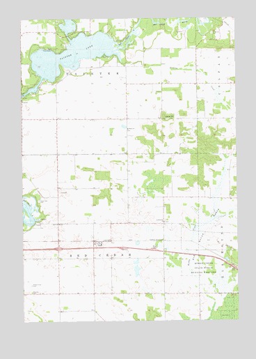
Rusk, WI USGS Topographic Map
Click on map above to begin viewing in our Map Viewer.

This topographic map contains these locations and features:
Feature Name Type Latitude Longitude GNIS ID View Map
Beyer Settlement School (historical)SchoolN44.9152°W91.7930°1578215View Map
Cedar Falls CemeteryCemeteryN44.9247°W91.8657°1562843View Map
Clearview School (historical)SchoolN44.9516°W91.8135°1578223View Map
Elk Mound MarshSwampN44.9150°W91.7691°1564527View Map
Hanke HillSummitN44.9591°W91.7921°1566038View Map
Hill Grove CemeteryCemeteryN44.9938°W91.7632°1566415View Map
Knapp Settlement School (historical)SchoolN44.9730°W91.7727°1578237View Map
Lone Pine School (historical)SchoolN44.8869°W91.8705°1578242View Map
Lyndale School (historical)SchoolN44.8794°W91.8343°1578245View Map
Menomonie Municipal Airport-Score FieldAirportN44.8936°W91.8714°1582070View Map
Muddy Creek State Public Hunting GroundsParkN44.8819°W91.7524°1570006View Map
Ney School (historical)SchoolN44.8858°W91.7929°1581380View Map
Potters Field CemeteryCemeteryN44.8897°W91.8699°1571848View Map
Prairie School (historical)SchoolN44.9514°W91.8543°1578258View Map
RuskPopulated PlaceN44.9077°W91.8341°1572746View Map
Rusk ChurchChurchN44.9152°W91.8546°1572748View Map
Rusk Post Office (historical)Post OfficeN44.9077°W91.8316°1838253View Map
Rusk School (historical)SchoolN44.9155°W91.8543°1578261View Map
Saint Katherine ChurchChurchN44.9158°W91.7927°1573201View Map
Sherbourne PrairieAreaN44.9111°W91.8341°1838258View Map
Sinking CreekStreamN44.9811°W91.8163°1574190View Map
Tainter ChurchChurchN44.9544°W91.8135°1575227View Map
Tainter LakePopulated PlaceN44.9891°W91.8477°1867667View Map
Tainter LakeReservoirN44.9775°W91.8561°1575230View Map
Tainter Lake Census Designated PlaceCensusN44.9882°W91.8437°2393252View Map
Town of Red CedarCivilN44.8869°W91.8355°1584001View Map
Town of TainterCivilN44.9875°W91.8338°1584266View Map

Note: Coordinates in the location and feature list above are referenced to NAD83 datum.


Copyright (C) 2008-2025 Ryan Niemi / Sunset Dynamics ... All Rights Reserved