TopoQuest Logo
Do you find TopoQuest useful?
Help keep TopoQuest running and adding new maps/features by donating!
Bitcoin:  19c7KJd3qBynnjoSw5npx9KScwjBe4ifkT
Litecoin:  LXs6TkuXGGXo1vDsWCkWVdjQX94eUKd6ui
Home View Maps Find Maps Find Places Resources & Links


Rutledge North, Georgia Topographic Map

USGS Map Title: Rutledge North, GA
USGS Map MRC: 33083F5
DRG (GeoTIFF) Download: o33083f5.tif


Neighboring USGS Topographic Map Quads:


  Monroe, GA  
33083G6
 

  High Shoals, GA  
33083G5
 

  Watkinsville, GA  
33083G4
 

  Social Circle, GA  
33083F6
 

  Rutledge North, GA  
33083F5
 

  Apalachee, GA  
33083F4
 

  Mansfield, GA  
33083E6
 

  Rutledge South, GA  
33083E5
 

  Madison, GA  
33083E4


Map MRC Location:

N34°
W84°
N34°
W83°
H8 H7 H6 H5 H4 H3 H2 H1
G8 G7 G6 G5 G4 G3 G2 G1
F8 F7 F6 F5 F4 F3 F2 F1
E8 E7 E6 E5 E4 E3 E2 E1
D8 D7 D6 D5 D4 D3 D2 D1
C8 C7 C6 C5 C4 C3 C2 C1
B8 B7 B6 B5 B4 B3 B2 B1
A8 A7 A6 A5 A4 A3 A2 A1
N33°
W84°
N33°
W83°

Rutledge North, GA USGS 1:24K Topographic Map Preview:
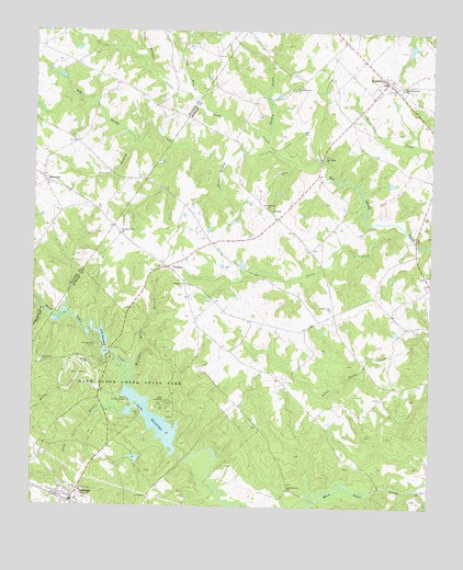
Rutledge North, GA USGS Topographic Map
Click on map above to begin viewing in our Map Viewer.

This topographic map contains these locations and features:
Feature Name Type Latitude Longitude GNIS ID View Map
Adcock DamDamN33.7401°W83.6216°338835View Map
Adcock LakeReservoirN33.7414°W83.6222°338836View Map
BostwickPopulated PlaceN33.7373°W83.5143°331211View Map
Callaway DamDamN33.7468°W83.5066°338601View Map
Callaway LakeReservoirN33.7463°W83.5062°338602View Map
Camp Daniel MorganLocaleN33.6521°W83.5943°312226View Map
Camp RutledgeLocaleN33.6529°W83.5824°312251View Map
Chestnut Grove CemeteryCemeteryN33.6967°W83.5792°2573751View Map
Chestnut Grove ChurchChurchN33.6965°W83.5979°312626View Map
City of BostwickCivilN33.7378°W83.5150°2403901View Map
City of RutledgeCivilN33.6263°W83.6113°2404661View Map
EbenezerPopulated PlaceN33.7112°W83.6218°326259View Map
Ebenezer ChurchChurchN33.7096°W83.6207°342667View Map
FairplayPopulated PlaceN33.6879°W83.5829°355759View Map
Fambro BridgeBridgeN33.6376°W83.5766°345984View Map
Gibbs Memorial ChurchChurchN33.7354°W83.5093°314579View Map
Green BranchStreamN33.7418°W83.5910°314821View Map
Greenwood School (historical)SchoolN33.6590°W83.5549°345989View Map
Gresham Grove Baptist ChurchChurchN33.7349°W83.5434°314889View Map
Gresham Grove Baptist Church CemeteryCemeteryN33.7350°W83.5436°2573945View Map
Hard Labor Creek State ParkParkN33.6532°W83.6035°315109View Map
Hardmans Mill (historical)LocaleN33.7265°W83.5588°345991View Map
Hester BranchStreamN33.7173°W83.5621°315349View Map
Ivey BranchStreamN33.7312°W83.5729°315967View Map
Klockner Airport (historical)AirportN33.7091°W83.5783°351690View Map
Lake BrantleyReservoirN33.6682°W83.6024°311733View Map
Lake Brantley DamDamN33.6651°W83.6002°336544View Map
Lake RutledgeReservoirN33.6478°W83.5868°322024View Map
Lake Rutledge DamDamN33.6385°W83.5793°336542View Map
Little CreekStreamN33.6971°W83.5068°317011View Map
Little Sandy CreekStreamN33.7179°W83.5485°317184View Map
Malcolms StorePopulated PlaceN33.7010°W83.5482°346002View Map
Mallory School (historical)SchoolN33.6798°W83.5143°346003View Map
McHugh Hill ChurchChurchN33.6301°W83.5438°317923View Map
McHughs Mill (historical)LocaleN33.6551°W83.6032°346005View Map
Mooney DamDamN33.6385°W83.5916°336528View Map
Mooney LakeReservoirN33.6377°W83.5926°336529View Map
Morgan County Fire Rescue Department Station 3BuildingN33.7364°W83.5116°2605009View Map
Morgan County Fire Rescue Department Station 6BuildingN33.6871°W83.5824°2604822View Map
Morgan County Fire Rescue Department Station 9BuildingN33.6293°W83.6094°2604540View Map
Mount Vernon Baptist ChurchChurchN33.7172°W83.5338°318908View Map
Mount Vernon Baptist Church CemeteryCemeteryN33.7174°W83.5339°2573962View Map
Mountain Hill BranchStreamN33.6604°W83.5924°319074View Map
Peters BranchStreamN33.7212°W83.5935°320408View Map
Prospect ChurchChurchN33.6837°W83.5768°321169View Map
Rock Spring ChurchChurchN33.7037°W83.5518°321752View Map
Rocky CreekStreamN33.6518°W83.6004°321824View Map
Ruthledge Police DepartmentBuildingN33.6262°W83.6120°2733524View Map
RutledgePopulated PlaceN33.6260°W83.6124°322022View Map
Sandy CreekPopulated PlaceN33.6760°W83.5302°346023View Map
Sandy Creek ChurchChurchN33.6773°W83.5310°322475View Map
Still BranchStreamN33.6493°W83.5960°323619View Map
Studdard CemeteryCemeteryN33.6629°W83.6221°323707View Map
Sweet Home Baptist ChurchChurchN33.7381°W83.5104°2573998View Map
Taylor FieldAirportN33.7239°W83.5649°351691View Map
Thomas and Knight CemeteryCemeteryN33.7223°W83.6141°342724View Map
Turkey CreekStreamN33.7235°W83.5518°324383View Map
Whitlock CemeteryCemeteryN33.7232°W83.5318°346036View Map

Note: Coordinates in the location and feature list above are referenced to NAD83 datum.


Copyright (C) 2008-2024 Ryan Niemi / Sunset Dynamics ... All Rights Reserved