TopoQuest Logo
Do you find TopoQuest useful?
Help keep TopoQuest running and adding new maps/features by donating!
Bitcoin:  19c7KJd3qBynnjoSw5npx9KScwjBe4ifkT
Litecoin:  LXs6TkuXGGXo1vDsWCkWVdjQX94eUKd6ui
Home View Maps Find Maps Find Places Resources & Links


Watkinsville, Georgia Topographic Map

USGS Map Title: Watkinsville, GA
USGS Map MRC: 33083G4
DRG (GeoTIFF) Download: o33083g4.tif


Neighboring USGS Topographic Map Quads:


  Statham, GA  
33083H5
 

  Athens West, GA  
33083H4
 

  Athens East, GA  
33083H3
 

  High Shoals, GA  
33083G5
 

  Watkinsville, GA  
33083G4
 

  Barnett Shoals, GA  
33083G3
 

  Rutledge North, GA  
33083F5
 

  Apalachee, GA  
33083F4
 

  Greshamville, GA  
33083F3


Map MRC Location:

N34°
W84°
N34°
W83°
H8 H7 H6 H5 H4 H3 H2 H1
G8 G7 G6 G5 G4 G3 G2 G1
F8 F7 F6 F5 F4 F3 F2 F1
E8 E7 E6 E5 E4 E3 E2 E1
D8 D7 D6 D5 D4 D3 D2 D1
C8 C7 C6 C5 C4 C3 C2 C1
B8 B7 B6 B5 B4 B3 B2 B1
A8 A7 A6 A5 A4 A3 A2 A1
N33°
W84°
N33°
W83°

Watkinsville, GA USGS 1:24K Topographic Map Preview:
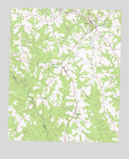
Watkinsville, GA USGS Topographic Map
Click on map above to begin viewing in our Map Viewer.

This topographic map contains these locations and features:
Feature Name Type Latitude Longitude GNIS ID View Map
Barnett LakeReservoirN33.8209°W83.4465°310811View Map
Bearden CemeteryCemeteryN33.8229°W83.4071°310954View Map
Bells LakeReservoirN33.8430°W83.4082°311057View Map
Bells Lake DamDamN33.8451°W83.4082°336506View Map
Bethel Baptist ChurchChurchN33.8668°W83.4118°356692View Map
BishopPopulated PlaceN33.8193°W83.4388°311456View Map
Bishop Baptist ChurchChurchN33.8218°W83.4368°356754View Map
Bishop CemeteryCemeteryN33.8218°W83.4438°311457View Map
Bishop Elementary SchoolSchoolN33.8215°W83.4360°356696View Map
Booths Academy (historical)SchoolN33.8668°W83.4321°356700View Map
Brown ChapelChurchN33.8226°W83.4518°311864View Map
Brown Chapel CemeteryCemeteryN33.8226°W83.4521°356704View Map
Bucks CreekStreamN33.7590°W83.4938°311986View Map
Cedar HillsPopulated PlaceN33.8626°W83.4163°356707View Map
Christian LakeReservoirN33.8596°W83.4226°356709View Map
City of WatkinsvilleCivilN33.8612°W83.4073°2405687View Map
Colham Ferry Elementary SchoolSchoolN33.8478°W83.4096°323694View Map
CoventryPopulated PlaceN33.7857°W83.3960°356712View Map
CrosstiesPopulated PlaceN33.8623°W83.4007°356713View Map
CumberlandPopulated PlaceN33.8507°W83.4627°356716View Map
Elder HeightsPopulated PlaceN33.8457°W83.4857°356727View Map
Elder RidgePopulated PlaceN33.8473°W83.4857°356728View Map
EssexPopulated PlaceN33.7890°W83.3957°356731View Map
FarmingtonPopulated PlaceN33.7762°W83.4235°331700View Map
Farmington CemeteryCemeteryN33.7721°W83.4246°1966389View Map
Farmington Post OfficePost OfficeN33.7760°W83.4235°356734View Map
Frazer CreekStreamN33.8112°W83.4807°355909View Map
Freeman CreekStreamN33.7632°W83.4582°314374View Map
Freeman Creek ChurchChurchN33.7726°W83.4235°355917View Map
Fullilove -Jackson CemeteryCemeteryN33.8565°W83.4932°314454View Map
Gun Point BendBendN33.8021°W83.4799°345990View Map
Harden HillsPopulated PlaceN33.8546°W83.4115°356743View Map
Hardigree CemeteryCemeteryN33.8407°W83.3899°315118View Map
Harris Shoals ParkParkN33.8643°W83.4207°356744View Map
Herman C Michael ParkParkN33.8626°W83.4816°356746View Map
HillcrestPopulated PlaceN33.8610°W83.4402°356749View Map
Horseshoe BendBendN33.7973°W83.4757°345993View Map
Huff CemeteryCemeteryN33.8018°W83.3940°315795View Map
Killarney WestPopulated PlaceN33.8698°W83.4363°356757View Map
Klutts CemeteryCemeteryN33.8476°W83.4421°316487View Map
Lake RossieReservoirN33.7904°W83.4609°321945View Map
Lake WildwoodPopulated PlaceN33.8573°W83.4346°356759View Map
Lake WildwoodReservoirN33.8565°W83.4350°356828View Map
Lampkin BranchStreamN33.8693°W83.4163°316604View Map
Laurel ChasePopulated PlaceN33.8429°W83.4860°356760View Map
Marshall CemeteryCemeteryN33.7596°W83.3790°317723View Map
Marshall EstatesPopulated PlaceN33.8543°W83.4171°356764View Map
Marshalls Mill (historical)LocaleN33.7690°W83.3957°356765View Map
Marshalls Store (historical)LocaleN33.7587°W83.3765°356766View Map
Mayne CemeteryCemeteryN33.7759°W83.3860°317821View Map
Mount Perry Baptist ChurchChurchN33.7776°W83.4799°318801View Map
Mount Perry Missionary Baptist Church CemeteryCemeteryN33.7778°W83.4794°2573952View Map
Mount Zion CemeteryCemeteryN33.7812°W83.4357°356769View Map
Mount Zion ChurchChurchN33.7818°W83.4354°319017View Map
Oconee CountyCivilN33.8349°W83.4371°356774View Map
Oconee County CourthouseBuildingN33.8635°W83.4102°356775View Map
Oconee County Elementary SchoolSchoolN33.8717°W83.4442°2545741View Map
Oconee County High SchoolSchoolN33.8612°W83.4564°356776View Map
Oconee County JailBuildingN33.8682°W83.4148°2733733View Map
Oconee County LibraryBuildingN33.8668°W83.4138°356777View Map
Oconee County Middle SchoolSchoolN33.8736°W83.4449°2545529View Map
Oconee County Primary SchoolSchoolN33.8720°W83.4469°356778View Map
Oconee County Sheriff's OfficeBuildingN33.8677°W83.4147°2733792View Map
Oconee Industrial ParkLocaleN33.8571°W83.4013°356779View Map
Oconee Plaza Shopping CenterLocaleN33.8735°W83.4404°356780View Map
Paradise FallsPopulated PlaceN33.8173°W83.4982°356786View Map
Poplar SpringsPopulated PlaceN33.8121°W83.4013°356791View Map
Poplar Springs CemeteryCemeteryN33.8068°W83.4021°356792View Map
Poplar Springs ChurchChurchN33.8110°W83.4010°321047View Map
Poplar Springs School (historical)SchoolN33.8121°W83.4015°356793View Map
Price Mill BridgeBridgeN33.7857°W83.4729°346016View Map
Quail RunPopulated PlaceN33.8487°W83.4321°356794View Map
Rehobeth CemeteryCemeteryN33.7715°W83.4829°321496View Map
Rehoboth (historical)Populated PlaceN33.7718°W83.4832°346018View Map
Robinson CreekStreamN33.8029°W83.4813°321692View Map
Robinson CreekStreamN33.8087°W83.4807°321693View Map
Sheats -Thompson CemeteryCemeteryN33.8251°W83.4854°322812View Map
South Main Street Historic DistrictParkN33.8621°W83.4082°356808View Map
South Oconee County Fire Department Station 2BuildingN33.7762°W83.4243°2604604View Map
Spirit of Life Tabernacle (historical)ChurchN33.7657°W83.4218°356810View Map
The BriarsPopulated PlaceN33.8654°W83.3902°356816View Map
Town of BishopCivilN33.8171°W83.4372°2405269View Map
Tramlin AcresPopulated PlaceN33.8487°W83.4357°356819View Map
Union CemeteryCemeteryN33.8590°W83.4570°356822View Map
Union ChurchChurchN33.8596°W83.4574°324536View Map
Victoria StationPopulated PlaceN33.8707°W83.3799°356824View Map
Wagnon CemeteryCemeteryN33.7584°W83.4618°324742View Map
WatkinsvillePopulated PlaceN33.8629°W83.4088°333373View Map
Watkinsville DivisionCivilN33.8337°W83.4342°1936631View Map
Watkinsville KindergartenSchoolN33.8648°W83.4063°356825View Map
Watkinsville Police DepartmentBuildingN33.8676°W83.4186°2733924View Map
Watkinsville Post OfficePost OfficeN33.8607°W83.4068°356826View Map
WestburyPopulated PlaceN33.8665°W83.4410°356827View Map
Westminster Christian AcademySchoolN33.8490°W83.4286°2545775View Map
Whitlow CreekStreamN33.8087°W83.4738°325236View Map
Woodis CemeteryCemeteryN33.8326°W83.4243°325529View Map

Note: Coordinates in the location and feature list above are referenced to NAD83 datum.


Copyright (C) 2008-2025 Ryan Niemi / Sunset Dynamics ... All Rights Reserved