TopoQuest Logo
Do you find TopoQuest useful?
Help keep TopoQuest running and adding new maps/features by donating!
Bitcoin:  19c7KJd3qBynnjoSw5npx9KScwjBe4ifkT
Litecoin:  LXs6TkuXGGXo1vDsWCkWVdjQX94eUKd6ui
Home View Maps Find Maps Find Places Resources & Links


Saint Paul, Virginia Topographic Map

USGS Map Title: Saint Paul, VA
USGS Map MRC: 36082H3
DRG (GeoTIFF) Download: o36082h3.tif


Neighboring USGS Topographic Map Quads:


  Caney Ridge, VA  
37082A4
 

  Nora, VA  
37082A3
 

  Duty, VA  
37082A2
 

  Coeburn, VA  
36082H4
 

  Saint Paul, VA  
36082H3
 

  Carbo, VA  
36082H2
 

  Dungannon, VA  
36082G4
 

  Moll Creek, VA  
36082G3
 

  Hansonville, VA  
36082G2


Map MRC Location:

N37°
W83°
N37°
W82°
H8 H7 H6 H5 H4 H3 H2 H1
G8 G7 G6 G5 G4 G3 G2 G1
F8 F7 F6 F5 F4 F3 F2 F1
E8 E7 E6 E5 E4 E3 E2 E1
D8 D7 D6 D5 D4 D3 D2 D1
C8 C7 C6 C5 C4 C3 C2 C1
B8 B7 B6 B5 B4 B3 B2 B1
A8 A7 A6 A5 A4 A3 A2 A1
N36°
W83°
N36°
W82°

Saint Paul, VA USGS 1:24K Topographic Map Preview:
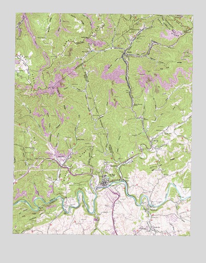
Saint Paul, VA USGS Topographic Map
Click on map above to begin viewing in our Map Viewer.

This topographic map contains these locations and features:
Feature Name Type Latitude Longitude GNIS ID View Map
Austin GapGapN36.9865°W82.3235°1462625View Map
Banner CemeteryCemeteryN36.8937°W82.3007°1462770View Map
Bear Wallow HollowValleyN36.9776°W82.2976°1462904View Map
Bee BranchStreamN36.9465°W82.2746°1462989View Map
Bellamy CemeteryCemeteryN36.8979°W82.3390°1463034View Map
Bickley CemeteryCemeteryN36.8854°W82.2776°1463296View Map
Bickley CemeteryCemeteryN36.8990°W82.3218°1463297View Map
Bickley CemeteryCemeteryN36.9040°W82.3329°1463298View Map
Bickley MillPopulated PlaceN36.8890°W82.2776°1848409View Map
Big BranchStreamN36.9543°W82.2654°1463312View Map
Big Bull TunnelTunnelN36.9176°W82.3590°1463330View Map
Big SpringSpringN36.8783°W82.2781°1463413View Map
Big Spring BranchStreamN36.8926°W82.2849°1463415View Map
BoodyPopulated PlaceN36.9059°W82.2971°1477128View Map
Bull HillSummitN36.9195°W82.3574°1499183View Map
Bull Hill School (historical)SchoolN36.9295°W82.3624°1496592View Map
Burton CemeteryCemeteryN36.9326°W82.3660°1464149View Map
Burtons FordCrossingN36.8915°W82.3399°1497501View Map
Burtons FordPopulated PlaceN36.8915°W82.3396°1499198View Map
Bush CemeteryCemeteryN36.9234°W82.3346°1464157View Map
Caledonia HollowValleyN36.9152°W82.3415°1464245View Map
Castle RunStreamN36.8879°W82.3179°1464527View Map
Castle SidingLocaleN36.8912°W82.3240°1464529View Map
CastlewoodPopulated PlaceN36.8901°W82.2796°1502780View Map
Castlewood Census Designated PlaceCensusN36.8782°W82.2878°2389286View Map
Castlewood Fire and Rescue Main StationBuildingN36.8906°W82.3063°2085960View Map
Chafin CemeteryCemeteryN36.9223°W82.2504°1464712View Map
Charles Bickley Memorial BridgeBridgeN36.9020°W82.3093°1496596View Map
Cherry Knob School (historical)SchoolN36.9807°W82.3407°1497370View Map
Cigarette HollowValleyN36.9766°W82.2825°1464925View Map
Couch CemeteryCemeteryN36.9582°W82.2593°1465281View Map
Craigen TunnelTunnelN36.9029°W82.3285°1465401View Map
Crooked BranchStreamN36.9226°W82.2771°1465453View Map
Curley HollowValleyN36.9224°W82.3467°1465539View Map
DantePopulated PlaceN36.9784°W82.2976°1465597View Map
Dante Census Designated PlaceCensusN36.9791°W82.2961°2630763View Map
Dante Elementary SchoolSchoolN36.9773°W82.2957°1498383View Map
Dante High School (historical)SchoolN36.9804°W82.3074°1498384View Map
Dante Post OfficePost OfficeN36.9777°W82.2976°2766451View Map
Dante Rescue Squad Main StationBuildingN36.9769°W82.2823°2721037View Map
Dante Rescue Squad SubstationBuildingN36.9201°W82.2906°2721162View Map
Dante Volunteer Fire Department Station 37BuildingN36.9729°W82.2952°2085963View Map
Dickenson CemeteryCemeteryN36.8932°W82.2732°1465767View Map
Dickenson CemeteryCemeteryN36.9026°W82.2557°1465768View Map
Dickenson CemeteryCemeteryN36.9120°W82.2754°1465769View Map
Dingus Memorial ChurchChurchN36.9493°W82.2910°1465811View Map
Dismal RidgeRidgeN36.9970°W82.3340°1465822View Map
DoradoPopulated PlaceN36.9079°W82.2704°1497517View Map
DwinaPopulated PlaceN36.9079°W82.3671°1499365View Map
Dwina HollowValleyN36.9124°W82.3641°1466066View Map
Dwina School (historical)SchoolN36.9076°W82.3688°1496609View Map
Dwina StationLocaleN36.9207°W82.3671°1466067View Map
Dye CemeteryCemeteryN36.9029°W82.3324°1466068View Map
Evans CemeteryCemeteryN36.9137°W82.3635°1466353View Map
Fields CemeteryCemeteryN36.8993°W82.2801°1466550View Map
Flat Top RidgeRidgeN36.9709°W82.2640°1466667View Map
Flint GapGapN36.9909°W82.2543°1466713View Map
Flying W AirportAirportN36.8892°W82.2992°2675575View Map
Fraley CemeteryCemeteryN36.9298°W82.2685°1466841View Map
Gibson CemeteryCemeteryN36.8854°W82.2765°1467066View Map
Glovier CemeteryCemeteryN36.9320°W82.3149°1467167View Map
Gose CemeteryCemeteryN36.8834°W82.3268°1467270View Map
Gose CemeteryCemeteryN36.9182°W82.3012°1467272View Map
Gose HollowValleyN36.9167°W82.3007°1467274View Map
Gose School (historical)SchoolN36.8765°W82.3385°1497530View Map
Granny BranchStreamN36.9407°W82.2843°1467350View Map
Gravel Lick ChurchChurchN36.9345°W82.2690°1467387View Map
Gravel Lick CreekStreamN36.9273°W82.2779°1467388View Map
Grindstone BranchStreamN36.9326°W82.2824°1467550View Map
Hall HollowValleyN36.8892°W82.3624°1467667View Map
HamlinPopulated PlaceN36.9282°W82.2785°1499517View Map
Hamlin BranchStreamN36.9334°W82.2821°1467686View Map
Hamlin ChurchChurchN36.9240°W82.2749°1467687View Map
Hardy HollowValleyN36.9094°W82.3201°1467743View Map
Hasn HollowValleyN36.8961°W82.3576°1467814View Map
HazelPopulated PlaceN36.9907°W82.2538°1499542View Map
Hazel School (historical)SchoolN36.9926°W82.2518°1498377View Map
Hileman CemeteryCemeteryN36.9245°W82.3221°1468044View Map
Holbrook CemeteryCemeteryN36.9426°W82.3151°1468124View Map
Holbrook CemeteryCemeteryN36.9523°W82.3204°1468125View Map
Holbrook TunnelTunnelN36.9248°W82.3713°1468127View Map
Honey BranchStreamN36.9165°W82.3004°1468207View Map
Honeycomb BranchStreamN36.9395°W82.3165°1468211View Map
Jessee CemeteryCemeteryN36.9243°W82.2571°1468728View Map
JohnPopulated PlaceN36.9654°W82.2957°1497540View Map
Kilgore CreekStreamN36.9979°W82.3685°1468992View Map
Kimberland HollowValleyN36.8876°W82.3528°1468997View Map
Laurel BranchStreamN36.9815°W82.3063°1469167View Map
Left Fork Lick CreekStreamN36.9776°W82.2979°1469292View Map
Lick CreekStreamN36.9057°W82.2996°1469395View Map
Lick Creek School (historical)SchoolN36.9523°W82.3246°1496626View Map
Little Bull TunnelTunnelN36.9170°W82.3649°1469491View Map
Lonesome (historical)Populated PlaceN36.9093°W82.3290°1496628View Map
Low GapGapN36.9995°W82.2715°1469887View Map
Lucas CemeteryCemeteryN36.9137°W82.2740°1469927View Map
Maize HollowValleyN36.9320°W82.3503°1470021View Map
McCoy CemeteryCemeteryN36.9759°W82.3457°1470240View Map
McCoy ChapelChurchN36.9862°W82.3535°1470244View Map
Meade CreekStreamN36.9157°W82.3424°1485322View Map
Meadows BranchStreamN36.9559°W82.3249°1470324View Map
Meadows CemeteryCemeteryN36.9598°W82.3349°1470325View Map
MorefieldPopulated PlaceN36.9137°W82.3021°1499764View Map
Moretz CemeteryCemeteryN36.9751°W82.3676°1470732View Map
Moses BranchStreamN36.8887°W82.3390°1470778View Map
Nancy RidgeRidgeN36.9482°W82.3440°1471317View Map
Phillips CemeteryCemeteryN36.9979°W82.2868°1472255View Map
Plaster CemeteryCemeteryN36.9143°W82.3257°1472464View Map
Powers CemeteryCemeteryN36.8826°W82.3582°1472748View Map
Price CemeteryCemeteryN36.9007°W82.3396°1472787View Map
Primitive ChurchChurchN36.9401°W82.3176°1496641View Map
Right Fork Lick CreekStreamN36.9776°W82.2979°1473221View Map
Riverside Industrial ParkLocaleN36.9029°W82.3049°1497569View Map
Robinette BranchStreamN36.9079°W82.3185°1473327View Map
Robinette CemeteryCemeteryN36.8923°W82.3346°1473333View Map
Robinson CemeteryCemeteryN36.9162°W82.3099°1473341View Map
RuralPopulated PlaceN36.9273°W82.3624°1496644View Map
Russell CreekStreamN36.8943°W82.3479°1473646View Map
Russian BranchStreamN36.8954°W82.2671°1473656View Map
Saint PaulPopulated PlaceN36.9054°W82.3110°1473855View Map
Saint Paul CemeteryCemeteryN36.9139°W82.3102°2774794View Map
Saint Paul Elementary SchoolSchoolN36.9084°W82.3096°2498406View Map
Saint Paul High SchoolSchoolN36.9086°W82.3097°1496645View Map
Saint Paul Police DepartmentBuildingN36.9047°W82.3125°2766960View Map
Saint Paul Post OfficePost OfficeN36.9041°W82.3117°2767260View Map
Saint Paul Volunteer Fire DepartmentBuildingN36.9038°W82.3097°2085831View Map
Sandy Ridge ChurchChurchN36.9676°W82.3735°1474043View Map
Sandy Ridge TunnelTunnelN36.9982°W82.3010°1474047View Map
Saylor CemeteryCemeteryN36.9590°W82.3635°1474089View Map
Selfe CemeteryCemeteryN36.9270°W82.2549°1474160View Map
Seven Spring CreekStreamN36.8845°W82.2785°1474176View Map
Shannon TunnelTunnelN36.8915°W82.3538°1474221View Map
Skeen CemeteryCemeteryN36.9762°W82.3399°1474642View Map
Squirrel HollowValleyN36.9755°W82.3001°1475044View Map
Stallard Memorial ChurchChurchN36.9234°W82.3604°1475057View Map
Straight HollowValleyN36.9794°W82.2974°1475234View Map
SunPopulated PlaceN36.9418°W82.2857°1500191View Map
Talbert CemeteryCemeteryN36.9059°W82.3485°1475438View Map
Temple HillPopulated PlaceN36.8787°W82.2757°1500209View Map
Temple Hill CemeteryCemeteryN36.8759°W82.2646°1475535View Map
Temple Hill High School (historical)SchoolN36.8801°W82.2768°1498390View Map
Temple Hill School (historical)SchoolN36.8768°W82.2704°1497586View Map
Three Forks CemeteryCemeteryN36.9568°W82.3254°1475693View Map
Town of Saint PaulCivilN36.9066°W82.3158°2391400View Map
Trammel (historical)Populated PlaceN36.9918°W82.2935°1498392View Map
Trammel GapGapN36.9918°W82.2935°1475834View Map
Virginia CityPopulated PlaceN36.9184°W82.3449°1500262View Map
Wells ChapelChurchN36.9290°W82.3304°1476444View Map
West DantePopulated PlaceN36.9790°W82.3215°1500294View Map
Wheeler CemeteryCemeteryN36.9073°W82.2971°1476551View Map
Whetstone RidgeRidgeN36.9159°W82.3318°1476562View Map
Willey CemeteryCemeteryN36.9234°W82.3229°1476744View Map
Wright CemeteryCemeteryN36.9295°W82.3349°1474297View Map
Zion ChurchChurchN36.9098°W82.2660°1474387View Map

Note: Coordinates in the location and feature list above are referenced to NAD83 datum.


Copyright (C) 2008-2025 Ryan Niemi / Sunset Dynamics ... All Rights Reserved