TopoQuest Logo
Do you find TopoQuest useful?
Help keep TopoQuest running and adding new maps/features by donating!
Bitcoin:  19c7KJd3qBynnjoSw5npx9KScwjBe4ifkT
Litecoin:  LXs6TkuXGGXo1vDsWCkWVdjQX94eUKd6ui
Home View Maps Find Maps Find Places Resources & Links


Billys Island, Georgia Topographic Map

USGS Map Title: Billys Island, GA
USGS Map MRC: 30082G3
DRG (GeoTIFF) Download: o30082g3.tif


Neighboring USGS Topographic Map Quads:


  Cravens Island, GA  
30082H4
 

  Dinner Pond, GA  
30082H3
 

  Double Lakes, GA  
30082H2
 

  The Pocket, GA  
30082G4
 

  Billys Island, GA  
30082G3
 

  Chase Prairie, GA  
30082G2
 

  Strange Island, GA  
30082F4
 

  Blackjack Island, GA  
30082F3
 

  Chesser Island, GA  
30082F2


Map MRC Location:

N31°
W83°
N31°
W82°
H8 H7 H6 H5 H4 H3 H2 H1
G8 G7 G6 G5 G4 G3 G2 G1
F8 F7 F6 F5 F4 F3 F2 F1
E8 E7 E6 E5 E4 E3 E2 E1
D8 D7 D6 D5 D4 D3 D2 D1
C8 C7 C6 C5 C4 C3 C2 C1
B8 B7 B6 B5 B4 B3 B2 B1
A8 A7 A6 A5 A4 A3 A2 A1
N30°
W83°
N30°
W82°

Billys Island, GA USGS 1:24K Topographic Map Preview:
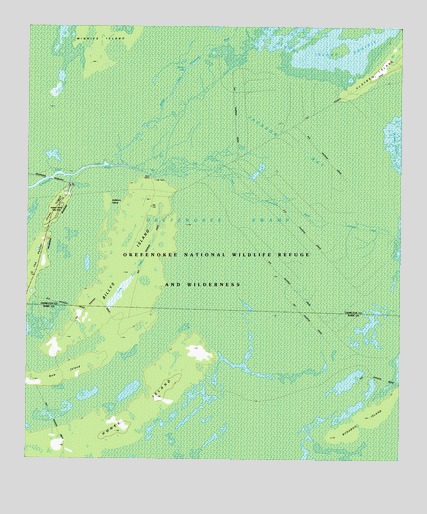
Billys Island, GA USGS Topographic Map
Click on map above to begin viewing in our Map Viewer.

This topographic map contains these locations and features:
Feature Name Type Latitude Longitude GNIS ID View Map
Billys IslandIslandN30.8052°W82.3404°311437View Map
Billys LakeSwampN30.8341°W82.3604°311439View Map
Bugaboo IslandIslandN30.7633°W82.2604°312007View Map
East Fork Suwannee RiverStreamN30.8349°W82.3429°313776View Map
Floyds IslandIslandN30.8616°W82.2590°314245View Map
Gallberry IslandIslandN30.8244°W82.3479°345235View Map
Honey IslandIslandN30.7633°W82.3365°356320View Map
Jackson BaySwampN30.8430°W82.2896°315994View Map
Jones IslandIslandN30.8208°W82.3674°316240View Map
Lee CemeteryCemeteryN30.8308°W82.3318°316730View Map
Long LakeSwampN30.7983°W82.3436°345234View Map
Middle Fork Suwannee RiverStreamN30.8347°W82.3432°318073View Map
Minnies IslandIslandN30.8738°W82.3501°318318View Map
Minnies LakeLakeN30.8622°W82.3226°345236View Map
New IslandIslandN30.7755°W82.3612°319452View Map
Okefenokee National Wildlife RefugeParkN30.7991°W82.3050°325830View Map
Okefenokee WildernessReserveN30.8039°W82.3024°2035234View Map
Stephen Foster State ParkLocaleN30.8255°W82.3612°351621View Map

Note: Coordinates in the location and feature list above are referenced to NAD83 datum.


Copyright (C) 2008-2025 Ryan Niemi / Sunset Dynamics ... All Rights Reserved