TopoQuest Logo
Do you find TopoQuest useful?
Help keep TopoQuest running and adding new maps/features by donating!
Bitcoin:  19c7KJd3qBynnjoSw5npx9KScwjBe4ifkT
Litecoin:  LXs6TkuXGGXo1vDsWCkWVdjQX94eUKd6ui
Home View Maps Find Maps Find Places Resources & Links


Saliz Pass, New Mexico Topographic Map

USGS Map Title: Saliz Pass, NM
USGS Map MRC: 33108E8
DRG (GeoTIFF) Download: o33108e8.tif


Neighboring USGS Topographic Map Quads:


  Maness Peak, AZ  
33109F1
 

  Bull Basin, NM  
33108F8
 

  Reserve, NM  
33108F7
 

  Blue, AZ  
33109E1
 

  Saliz Pass, NM  
33108E8
 

  O Block Canyon, NM  
33108E7
 

  Alma Mesa, AZ  
33109D1
 

  Alma, NM  
33108D8
 

  Mogollon, NM  
33108D7


Map MRC Location:

N34°
W109°
N34°
W108°
H8 H7 H6 H5 H4 H3 H2 H1
G8 G7 G6 G5 G4 G3 G2 G1
F8 F7 F6 F5 F4 F3 F2 F1
E8 E7 E6 E5 E4 E3 E2 E1
D8 D7 D6 D5 D4 D3 D2 D1
C8 C7 C6 C5 C4 C3 C2 C1
B8 B7 B6 B5 B4 B3 B2 B1
A8 A7 A6 A5 A4 A3 A2 A1
N33°
W109°
N33°
W108°

Saliz Pass, NM USGS 1:24K Topographic Map Preview:
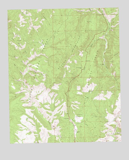
Saliz Pass, NM USGS Topographic Map
Click on map above to begin viewing in our Map Viewer.

This topographic map contains these locations and features:
Feature Name Type Latitude Longitude GNIS ID View Map
Bang Tail CanyonValleyN33.5628°W108.9842°903540View Map
Bear CanyonValleyN33.5487°W108.9790°903636View Map
Bear Canyon CorralLocaleN33.5487°W108.9801°913181View Map
Bisquit TankReservoirN33.6125°W108.9070°903842View Map
Blue Range WildernessReserveN33.5609°W108.9868°912784View Map
Brushy Canyon CorralLocaleN33.5056°W108.9020°904113View Map
Brushy Canyon TankReservoirN33.5694°W108.9188°904114View Map
Brushy MountainsRangeN33.5820°W108.9303°920570View Map
Brushy WellWellN33.5639°W108.9281°904125View Map
Buckskin CanyonValleyN33.6198°W108.9795°904156View Map
Chimney RockSummitN33.5962°W108.9906°905107View Map
Chimney Rock CanyonValleyN33.5767°W108.9778°905109View Map
Cottonwood CampgroundLocaleN33.6189°W108.8940°905395View Map
Cottonwood CanyonValleyN33.6189°W108.8931°905409View Map
Dangerous Park CanyonValleyN33.5892°W108.9615°905589View Map
Frying Pan CanyonValleyN33.5076°W108.8831°906421View Map
Gordon CanyonValleyN33.6081°W108.8862°906660View Map
Gut Ache CorralLocaleN33.5167°W108.9270°913177View Map
Gut Ache MesaSummitN33.5162°W108.9276°920607View Map
Indian Peak TankReservoirN33.5073°W108.9692°913176View Map
Javeling TankReservoirN33.5706°W108.9098°913183View Map
Jones CanyonValleyN33.6220°W108.9067°907427View Map
Kelly CampLocaleN33.5151°W108.9517°907523View Map
Kelly Tank Number 2ReservoirN33.5244°W108.9206°907531View Map
Kelly TanksReservoirN33.5425°W108.9140°907532View Map
L Kelly RanchLocaleN33.5187°W108.8890°907598View Map
Lewis TankReservoirN33.5318°W108.8774°913187View Map
Line Gap TankReservoirN33.5414°W108.9431°913180View Map
Little Joe TankReservoirN33.5426°W108.8976°913186View Map
Little Joe Trick TankReservoirN33.5454°W108.8970°913185View Map
Lower Gut Ache TankReservoirN33.5093°W108.9258°906787View Map
Martinez CanyonValleyN33.5962°W108.8920°908432View Map
Martinez RanchLocaleN33.5998°W108.8920°908439View Map
Old Highway TankReservoirN33.5463°W108.9371°913179View Map
Pueblo ParkParkN33.5931°W108.9615°909880View Map
Pueblo Park CampgroundLocaleN33.5934°W108.9615°2038633View Map
Pueblo Park CorralLocaleN33.5959°W108.9626°909881View Map
Pueblo Park SpringSpringN33.5934°W108.9624°913182View Map
Pup CanyonValleyN33.5681°W108.9784°909901View Map
Ribbon TankReservoirN33.5234°W108.9819°910151View Map
River TankReservoirN33.5201°W108.8848°2038650View Map
Saliz CorralLocaleN33.5503°W108.8790°913184View Map
Saliz HillSummitN33.5839°W108.9003°910563View Map
Saliz Mountain TankReservoirN33.5471°W108.9115°910564View Map
Saliz PassGapN33.5759°W108.9128°910567View Map
Serna RanchLocaleN33.5723°W108.8934°910947View Map
Six Bar TankReservoirN33.5044°W108.9015°913170View Map
Tige CanyonValleyN33.5584°W108.9859°25413View Map
Upper Gut Ache TankReservoirN33.5257°W108.9187°907530View Map
West Fork Pueblo CreekStreamN33.5723°W108.9795°912237View Map
Willie Kelly PlaceLocaleN33.5195°W108.9192°913178View Map
Willies TankReservoirN33.5222°W108.9392°912396View Map
WS CorralLocaleN33.5373°W108.9928°912126View Map

Note: Coordinates in the location and feature list above are referenced to NAD83 datum.


Copyright (C) 2008-2025 Ryan Niemi / Sunset Dynamics ... All Rights Reserved