TopoQuest Logo
Do you find TopoQuest useful?
Help keep TopoQuest running and adding new maps/features by donating!
Bitcoin:  19c7KJd3qBynnjoSw5npx9KScwjBe4ifkT
Litecoin:  LXs6TkuXGGXo1vDsWCkWVdjQX94eUKd6ui
Home View Maps Find Maps Find Places Resources & Links


O Block Canyon, New Mexico Topographic Map

USGS Map Title: O Block Canyon, NM
USGS Map MRC: 33108E7
DRG (GeoTIFF) Download: o33108e7.tif


Neighboring USGS Topographic Map Quads:


  Bull Basin, NM  
33108F8
 

  Reserve, NM  
33108F7
 

  Milligan Mountain, NM  
33108F6
 

  Saliz Pass, NM  
33108E8
 

  O Block Canyon, NM  
33108E7
 

  Sign Camp Mountain, NM  
33108E6
 

  Alma, NM  
33108D8
 

  Mogollon, NM  
33108D7
 

  Bearwallow Mountain, NM  
33108D6


Map MRC Location:

N34°
W109°
N34°
W108°
H8 H7 H6 H5 H4 H3 H2 H1
G8 G7 G6 G5 G4 G3 G2 G1
F8 F7 F6 F5 F4 F3 F2 F1
E8 E7 E6 E5 E4 E3 E2 E1
D8 D7 D6 D5 D4 D3 D2 D1
C8 C7 C6 C5 C4 C3 C2 C1
B8 B7 B6 B5 B4 B3 B2 B1
A8 A7 A6 A5 A4 A3 A2 A1
N33°
W109°
N33°
W108°

O Block Canyon, NM USGS 1:24K Topographic Map Preview:
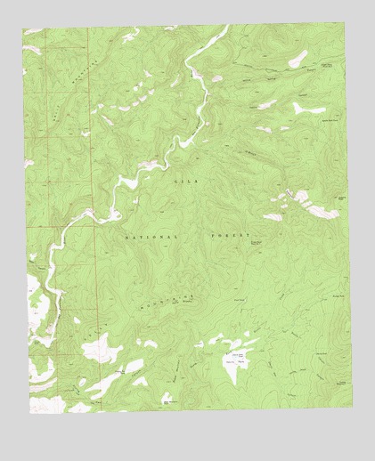
O Block Canyon, NM USGS Topographic Map
Click on map above to begin viewing in our Map Viewer.

This topographic map contains these locations and features:
Feature Name Type Latitude Longitude GNIS ID View Map
Apache PeakSummitN33.5678°W108.7551°903234View Map
Apache Peak Pit TankReservoirN33.5664°W108.7507°913158View Map
Apache Peak TankReservoirN33.5932°W108.7606°903236View Map
Black MountainSummitN33.5178°W108.8173°903881View Map
Black Mountain TankReservoirN33.5026°W108.8240°903889View Map
Brushy TankReservoirN33.5390°W108.8035°913167View Map
Cripple Saddle TankReservoirN33.5398°W108.8348°913165View Map
Devils CanyonValleyN33.5203°W108.7890°905731View Map
Devils Den CanyonValleyN33.5201°W108.7937°905736View Map
Devils ParkFlatN33.5156°W108.7953°905741View Map
Devils Park CorralLocaleN33.5220°W108.7948°913168View Map
Devils Park TankReservoirN33.5173°W108.7955°905742View Map
Devils TankReservoirN33.5175°W108.7646°905744View Map
Frisco Plaza Tank Number 1ReservoirN33.5538°W108.7890°906415View Map
Frisco Plaza Tank Number 2ReservoirN33.6107°W108.7550°906416View Map
Frying Pan TankReservoirN33.5125°W108.8381°906422View Map
Frying Pan WellWellN33.5073°W108.8581°906423View Map
Gatlin CanyonValleyN33.6026°W108.8042°906496View Map
Hells Hole CanyonValleyN33.5098°W108.7795°906920View Map
K Kelly RanchLocaleN33.5237°W108.8728°907501View Map
Kelly BrushySummitN33.5356°W108.8190°907522View Map
Kelly Brushy TankReservoirN33.5496°W108.8432°913164View Map
Kelly MountainsRangeN33.5309°W108.8384°920621View Map
Lewis TankReservoirN33.5289°W108.8709°913166View Map
O Block CanyonValleyN33.5881°W108.8109°909234View Map
Saliz CanyonValleyN33.5448°W108.8662°910561View Map
Saliz MountainsRangeN33.6081°W108.8540°920687View Map
Saliz TankReservoirN33.5976°W108.8517°913173View Map
Sally TankReservoirN33.5756°W108.8691°913175View Map
Trail TankReservoirN33.5347°W108.7920°911787View Map
Tub SpringSpringN33.5825°W108.8640°913174View Map
Turkey MountainSummitN33.5081°W108.7526°911876View Map
Turkey TankReservoirN33.5364°W108.7577°911905View Map
West Side Tank NorthReservoirN33.6147°W108.8308°913171View Map
West Side Tank SouthReservoirN33.5980°W108.8230°913172View Map
Willow Spring CanyonValleyN33.6039°W108.8045°912416View Map

Note: Coordinates in the location and feature list above are referenced to NAD83 datum.


Copyright (C) 2008-2025 Ryan Niemi / Sunset Dynamics ... All Rights Reserved