TopoQuest Logo
Do you find TopoQuest useful?
Help keep TopoQuest running and adding new maps/features by donating!
Bitcoin:  19c7KJd3qBynnjoSw5npx9KScwjBe4ifkT
Litecoin:  LXs6TkuXGGXo1vDsWCkWVdjQX94eUKd6ui
Home View Maps Find Maps Find Places Resources & Links


Bingham Lake, Minnesota Topographic Map

USGS Map Title: Bingham Lake, MN
USGS Map MRC: 43095H1
DRG (GeoTIFF) Download: o43095h1.tif


Neighboring USGS Topographic Map Quads:


  Jeffers, MN  
44095A2
 

  Sanborn SE, MN  
44095A1
 

  Comfrey, MN  
44094A8
 

  Harder Lake, MN  
43095H2
 

  Bingham Lake, MN  
43095H1
 

  Mountain Lake, MN  
43094H8
 

  Wilder, MN  
43095G2
 

  Windom, MN  
43095G1
 

  Bergen, MN  
43094G8


Map MRC Location:

N44°
W96°
N44°
W95°
H8 H7 H6 H5 H4 H3 H2 H1
G8 G7 G6 G5 G4 G3 G2 G1
F8 F7 F6 F5 F4 F3 F2 F1
E8 E7 E6 E5 E4 E3 E2 E1
D8 D7 D6 D5 D4 D3 D2 D1
C8 C7 C6 C5 C4 C3 C2 C1
B8 B7 B6 B5 B4 B3 B2 B1
A8 A7 A6 A5 A4 A3 A2 A1
N43°
W96°
N43°
W95°

Bingham Lake, MN USGS 1:24K Topographic Map Preview:
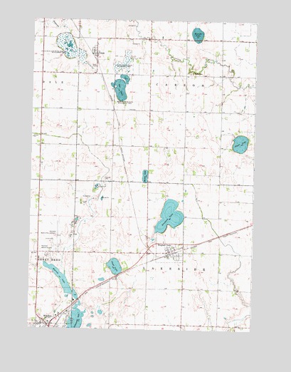
Bingham Lake, MN USGS Topographic Map
Click on map above to begin viewing in our Map Viewer.

This topographic map contains these locations and features:
Feature Name Type Latitude Longitude GNIS ID View Map
Abby ParkParkN43.8772°W95.1205°2051059View Map
Assembly of God ChurchChurchN43.8888°W95.1205°2051028View Map
Barish LakeLakeN43.9947°W95.0333°639658View Map
Bingham Fire HallBuildingN43.9066°W95.0464°2051110View Map
Bingham LakeLocaleN43.9066°W95.0433°2051108View Map
Bingham LakeLakeN43.9209°W95.0469°640154View Map
Bingham LakePopulated PlaceN43.9066°W95.0464°640155View Map
Bingham Post OfficePost OfficeN43.9066°W95.0464°2051109View Map
Carson CemeteryCemeteryN43.9783°W95.0350°640938View Map
City of Bingham LakeCivilN43.9095°W95.0461°2394169View Map
Clear LakeLakeN43.9004°W95.0770°641274View Map
Cottonwood LakeLakeN43.8778°W95.0988°641536View Map
DelftPopulated PlaceN43.9863°W95.0889°642752View Map
Delft (historical)LocaleN43.9838°W95.0905°2051016View Map
Delft CemeteryCemeteryN43.9814°W95.0898°642753View Map
Delft Post OfficePost OfficeN43.9863°W95.0889°2051017View Map
Delft State Wildlife Management AreaParkN43.9791°W95.0733°642754View Map
Eagle LakeLakeN43.9508°W95.0080°643013View Map
Eagle LakeReservoirN43.9466°W95.0069°1776172View Map
Eagle Lake DamDamN43.9466°W95.0069°1776171View Map
First Baptist ChurchChurchN43.9066°W95.0464°2051111View Map
Hartberg Medical ClinicHospitalN43.8788°W95.1164°2051042View Map
Immanuel Mennonite ChurchChurchN43.9858°W95.0892°2051018View Map
Lasting Joy ChurchChurchN43.8897°W95.1197°2051034View Map
Little Swan Lake State Wildlife Management AParkN43.9880°W95.1050°646946View Map
Maiden LakeLakeN43.9370°W95.0611°647393View Map
Rat LakeLakeN43.9717°W95.0759°649837View Map
Resthaven Memory GardensCemeteryN43.9074°W95.1189°649940View Map
Seventh Day Adventist ChurchChurchN43.8883°W95.1205°2051038View Map
Swan LakeSwampN43.9888°W95.1055°652898View Map
Tegels ParkParkN43.8755°W95.1036°2051058View Map
Township of CarsonCivilN43.9777°W95.0396°663757View Map
Township of LakesideCivilN43.8907°W95.0396°664702View Map
Victory Baptist ChurchChurchN43.9077°W95.0433°2051112View Map
Voth CemeteryCemeteryN43.9638°W95.0711°653690View Map
Warren LakeLakeN43.8953°W95.1067°653788View Map
Warren LakeReservoirN43.8883°W95.1119°1776170View Map
Warren Lake DamDamN43.8883°W95.1119°1776169View Map
Windom Area HospitalHospitalN43.8794°W95.1130°2051041View Map
Windom Family Medical CenterHospitalN43.8786°W95.1161°2051039View Map
Windom Municipal AirportAirportN43.9134°W95.1094°660478View Map

Note: Coordinates in the location and feature list above are referenced to NAD83 datum.


Copyright (C) 2008-2025 Ryan Niemi / Sunset Dynamics ... All Rights Reserved