TopoQuest Logo
Do you find TopoQuest useful?
Help keep TopoQuest running and adding new maps/features by donating!
Bitcoin:  19c7KJd3qBynnjoSw5npx9KScwjBe4ifkT
Litecoin:  LXs6TkuXGGXo1vDsWCkWVdjQX94eUKd6ui
Home View Maps Find Maps Find Places Resources & Links


Windom, Minnesota Topographic Map

USGS Map Title: Windom, MN
USGS Map MRC: 43095G1
DRG (GeoTIFF) Download: o43095g1.tif


Neighboring USGS Topographic Map Quads:


  Harder Lake, MN  
43095H2
 

  Bingham Lake, MN  
43095H1
 

  Mountain Lake, MN  
43094H8
 

  Wilder, MN  
43095G2
 

  Windom, MN  
43095G1
 

  Bergen, MN  
43094G8
 

  Lakefield, MN  
43095F2
 

  Lakefield NE, MN  
43095F1
 

  Jackson NW, MN  
43094F8


Map MRC Location:

N44°
W96°
N44°
W95°
H8 H7 H6 H5 H4 H3 H2 H1
G8 G7 G6 G5 G4 G3 G2 G1
F8 F7 F6 F5 F4 F3 F2 F1
E8 E7 E6 E5 E4 E3 E2 E1
D8 D7 D6 D5 D4 D3 D2 D1
C8 C7 C6 C5 C4 C3 C2 C1
B8 B7 B6 B5 B4 B3 B2 B1
A8 A7 A6 A5 A4 A3 A2 A1
N43°
W96°
N43°
W95°

Windom, MN USGS 1:24K Topographic Map Preview:
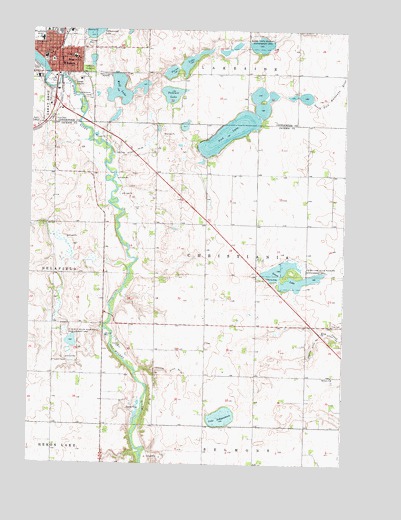
Windom, MN USGS Topographic Map
Click on map above to begin viewing in our Map Viewer.

This topographic map contains these locations and features:
Feature Name Type Latitude Longitude GNIS ID View Map
American Lutheran ChurchChurchN43.8658°W95.1108°2051027View Map
Banks State Wildlife Management AreaParkN43.8711°W95.0361°639619View Map
Bethany CemeteryCemeteryN43.7741°W95.0039°2048792View Map
Bethany ChurchChurchN43.7750°W95.0039°640000View Map
Caraway State Wildlife Management AreaParkN43.7841°W95.1089°640888View Map
Christiana Norwegian CemeteryCemeteryN43.7848°W95.0543°2048793View Map
City of WindomCivilN43.8738°W95.1205°2397339View Map
Cottonwood County CourthouseBuildingN43.8661°W95.1169°2051052View Map
Cottonwood County FairgroundsLocaleN43.8713°W95.1225°2051051View Map
Cottonwood County Historical SocietyBuildingN43.8652°W95.1175°2051045View Map
Cottonwood County JailBuildingN43.8656°W95.1197°2758821View Map
Cottonwood County Sheriff's OfficeBuildingN43.8656°W95.1196°2051044View Map
Cottonwood County Waterfowl Production AreaParkN43.8509°W95.0943°2765255View Map
Episcopal Church of the Good ShepherdChurchN43.8663°W95.1189°2051029View Map
Evangelical Free ChurchChurchN43.8675°W95.1180°2051030View Map
First Baptist ChurchChurchN43.8530°W95.1178°2051031View Map
First Presbyterian ChurchChurchN43.8677°W95.1175°2051032View Map
Fish LakeReservoirN43.8709°W95.0340°1776174View Map
Fish LakeLakeN43.8456°W95.0462°643672View Map
Fish Lake Census Designated PlaceCensusN43.8404°W95.0477°2583776View Map
Fish Lake DamDamN43.8700°W95.0353°1776173View Map
Good Samaritan Community Care CenterHospitalN43.8613°W95.1225°2051040View Map
Highland SchoolSchoolN43.8666°W95.1086°644956View Map
Island ParkParkN43.8597°W95.1183°645517View Map
Judicial Ditch Number SevenCanalN43.7763°W95.0694°645971View Map
Judicial Ditch Number SevenCanalN43.7838°W95.0122°645972View Map
Judicial Ditch Number SixtyfourCanalN43.8391°W95.0864°645965View Map
Kastle Kingdom ParkParkN43.8700°W95.1061°2051054View Map
KDOM-AM (Windom)TowerN43.8613°W95.0975°663270View Map
Lake IndependenceLakeN43.7633°W95.0476°645397View Map
Lakeview CemeteryCemeteryN43.8633°W95.1031°646429View Map
Laurs LakeReservoirN43.8055°W95.0267°646528View Map
Laurs Lake State Wildlife Management AreaParkN43.8050°W95.0197°646529View Map
Legion FieldParkN43.8700°W95.1058°2051055View Map
Living Word Lutheran ChurchChurchN43.8550°W95.1186°2051035View Map
Lowers Lake WaysideLocaleN43.8036°W95.0303°2048818View Map
Lutheran Church of Our SaviorChurchN43.8686°W95.1158°2051036View Map
Mayflower ParkParkN43.8569°W95.1047°2051056View Map
Parso LakeLakeN43.8651°W95.0645°649170View Map
Saint Francis Xavier Catholic ChurchChurchN43.8744°W95.1194°2051037View Map
Saint Francis Xavier CemeteryCemeteryN43.8556°W95.1016°650590View Map
Summit LakeLakeN43.8564°W95.0696°652793View Map
Township of ChristianiaCivilN43.8044°W95.0351°663801View Map
Turner FieldAirportN43.8666°W95.0170°660073View Map
WindomLocaleN43.8727°W95.1114°2051053View Map
WindomPopulated PlaceN43.8663°W95.1169°654245View Map
Windom City HallBuildingN43.8661°W95.1183°2051049View Map
Windom Police DepartmentBuildingN43.8656°W95.1194°2758591View Map
Windom Post OfficePost OfficeN43.8661°W95.1180°2051046View Map
Windom Public LibraryBuildingN43.8661°W95.1183°2051050View Map
Windom Volunteer Fire DepartmentBuildingN43.8657°W95.1190°2051048View Map
Winfair SchoolSchoolN43.8722°W95.1214°654252View Map
Witt Memorial ParkParkN43.8661°W95.1197°2051057View Map
Wolf LakeLakeN43.8574°W95.0906°654307View Map

Note: Coordinates in the location and feature list above are referenced to NAD83 datum.


Copyright (C) 2008-2025 Ryan Niemi / Sunset Dynamics ... All Rights Reserved