TopoQuest Logo
Do you find TopoQuest useful?
Help keep TopoQuest running and adding new maps/features by donating!
Bitcoin:  19c7KJd3qBynnjoSw5npx9KScwjBe4ifkT
Litecoin:  LXs6TkuXGGXo1vDsWCkWVdjQX94eUKd6ui
Home View Maps Find Maps Find Places Resources & Links


Salt Springs, Florida Topographic Map

USGS Map Title: Salt Springs, FL
USGS Map MRC: 29081C6
DRG (GeoTIFF) Download: o29081c6.tif


Neighboring USGS Topographic Map Quads:


  Lake Delancy, FL  
29081D7
 

  Welaka, FL  
29081D6
 

  Crescent City, FL  
29081D5
 

  Lake Kerr, FL  
29081C7
 

  Salt Springs, FL  
29081C6
 

  Welaka SE, FL  
29081C5
 

  Halfmoon Lake, FL  
29081B7
 

  Juniper Springs, FL  
29081B6
 

  Astor, FL  
29081B5


Map MRC Location:

N30°
W82°
N30°
W81°
H8 H7 H6 H5 H4 H3 H2 H1
G8 G7 G6 G5 G4 G3 G2 G1
F8 F7 F6 F5 F4 F3 F2 F1
E8 E7 E6 E5 E4 E3 E2 E1
D8 D7 D6 D5 D4 D3 D2 D1
C8 C7 C6 C5 C4 C3 C2 C1
B8 B7 B6 B5 B4 B3 B2 B1
A8 A7 A6 A5 A4 A3 A2 A1
N29°
W82°
N29°
W81°

Salt Springs, FL USGS 1:24K Topographic Map Preview:
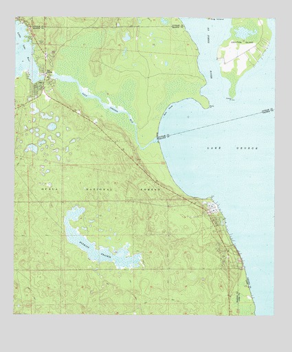
Salt Springs, FL USGS Topographic Map
Click on map above to begin viewing in our Map Viewer.

This topographic map contains these locations and features:
Feature Name Type Latitude Longitude GNIS ID View Map
Christian Church of Salt SpringsChurchN29.3742°W81.7497°306872View Map
Drayton IslandIslandN29.3616°W81.6406°305598View Map
Forest Community ChurchChurchN29.2711°W81.6448°306873View Map
Hopkins CampgroundLocaleN29.2755°W81.6937°307051View Map
Hopkins PrairieSwampN29.2757°W81.7065°305832View Map
Hughes IslandIslandN29.2605°W81.7362°307805View Map
Joseph M Hernandez GrantCivilN29.3378°W81.7006°306952View Map
Kinsley PointCapeN29.3405°W81.6454°305912View Map
Lisk PointCapeN29.3000°W81.6556°305949View Map
Marion County Fire Rescue Station 15 Salt SpringsBuildingN29.3644°W81.7404°2377790View Map
Marion County Sheriff's Office - Northeast DistrictBuildingN29.3645°W81.7398°2333124View Map
Memorial GardensCemeteryN29.3747°W81.7492°2377792View Map
Rocky PointCapeN29.3375°W81.6565°306303View Map
Salt CoveBayN29.3346°W81.6767°306337View Map
Salt SpringsPopulated PlaceN29.3511°W81.7351°306338View Map
Salt Springs BarBarN29.3322°W81.6704°307806View Map
Salt Springs CampgroundLocaleN29.3569°W81.7320°307049View Map
Salt Springs Electric SubstationBuildingN29.3700°W81.7419°2377791View Map
Salt Springs Post OfficePost OfficeN29.3583°W81.7369°2377789View Map
Salt Springs RunStreamN29.3241°W81.6812°306339View Map
Salt Springs Run MarinaHarborN29.3493°W81.7301°2452251View Map
Salt Springs Tower (historical)TowerN29.3639°W81.7373°306951View Map
Salt Springs Village Mobile Home ParkPopulated PlaceN29.3532°W81.7371°2448983View Map
Yellow BluffPopulated PlaceN29.2761°W81.6423°307050View Map

Note: Coordinates in the location and feature list above are referenced to NAD83 datum.


Copyright (C) 2008-2025 Ryan Niemi / Sunset Dynamics ... All Rights Reserved