TopoQuest Logo
Do you find TopoQuest useful?
Help keep TopoQuest running and adding new maps/features by donating!
Bitcoin:  19c7KJd3qBynnjoSw5npx9KScwjBe4ifkT
Litecoin:  LXs6TkuXGGXo1vDsWCkWVdjQX94eUKd6ui
Home View Maps Find Maps Find Places Resources & Links


Welaka SE, Florida Topographic Map

USGS Map Title: Welaka SE, FL
USGS Map MRC: 29081C5
DRG (GeoTIFF) Download: o29081c5.tif


Neighboring USGS Topographic Map Quads:


  Welaka, FL  
29081D6
 

  Crescent City, FL  
29081D5
 

  Saint Johns Park, FL  
29081D4
 

  Salt Springs, FL  
29081C6
 

  Welaka SE, FL  
29081C5
 

  Seville, FL  
29081C4
 

  Juniper Springs, FL  
29081B6
 

  Astor, FL  
29081B5
 

  Pierson, FL  
29081B4


Map MRC Location:

N30°
W82°
N30°
W81°
H8 H7 H6 H5 H4 H3 H2 H1
G8 G7 G6 G5 G4 G3 G2 G1
F8 F7 F6 F5 F4 F3 F2 F1
E8 E7 E6 E5 E4 E3 E2 E1
D8 D7 D6 D5 D4 D3 D2 D1
C8 C7 C6 C5 C4 C3 C2 C1
B8 B7 B6 B5 B4 B3 B2 B1
A8 A7 A6 A5 A4 A3 A2 A1
N29°
W82°
N29°
W81°

Welaka SE, FL USGS 1:24K Topographic Map Preview:
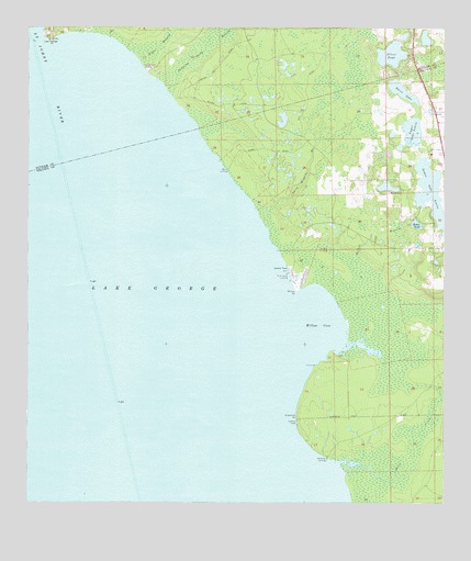
Welaka SE, FL USGS Topographic Map
Click on map above to begin viewing in our Map Viewer.

This topographic map contains these locations and features:
Feature Name Type Latitude Longitude GNIS ID View Map
Andrew Storrs GrantCivilN29.3203°W81.5470°293662View Map
Baker PondLakeN29.3234°W81.5080°278054View Map
Barrs LandingLocaleN29.3380°W81.5648°295110View Map
Braddock CemeteryCemeteryN29.3434°W81.5219°2581860View Map
C W Clarke GrantCivilN29.2958°W81.5198°306971View Map
Davis LakeLakeN29.3585°W81.5126°281326View Map
Deadman LandingPopulated PlaceN29.2619°W81.5345°294741View Map
Heirs of Wiggins GrantCivilN29.3364°W81.5623°303971View Map
Hendersons LandingLocaleN29.3641°W81.5895°300900View Map
Jumping Gully BranchSwampN29.3689°W81.5734°307385View Map
Lake GeorgeLakeN29.2856°W81.5958°305722View Map
Lake George PointCapeN29.3725°W81.6192°306645View Map
Lower Lake LouiseLakeN29.3322°W81.5040°286168View Map
Ninemile PointCapeN29.2725°W81.5440°287743View Map
Patty Wiggins BranchStreamN29.3266°W81.5554°288582View Map
Pine Island LandingLocaleN29.3105°W81.5465°295538View Map
Pine Island MarinaHarborN29.3119°W81.5461°2452368View Map
Price CreekSwampN29.2655°W81.5087°307391View Map
Seville Census Designated PlaceCensusN29.3364°W81.5065°2583381View Map
Silver PondLakeN29.3681°W81.5158°291134View Map
Upper Lake LouiseLakeN29.3480°W81.5094°292705View Map
Willow CoveBayN29.2981°W81.5364°293355View Map
Willow Cove BranchStreamN29.3130°W81.5259°293356View Map
Willow PointCapeN29.3055°W81.5442°293360View Map

Note: Coordinates in the location and feature list above are referenced to NAD83 datum.


Copyright (C) 2008-2025 Ryan Niemi / Sunset Dynamics ... All Rights Reserved