TopoQuest Logo
Do you find TopoQuest useful?
Help keep TopoQuest running and adding new maps/features by donating!
Bitcoin:  19c7KJd3qBynnjoSw5npx9KScwjBe4ifkT
Litecoin:  LXs6TkuXGGXo1vDsWCkWVdjQX94eUKd6ui
Home View Maps Find Maps Find Places Resources & Links


Astor, Florida Topographic Map

USGS Map Title: Astor, FL
USGS Map MRC: 29081B5
DRG (GeoTIFF) Download: o29081b5.tif


Neighboring USGS Topographic Map Quads:


  Salt Springs, FL  
29081C6
 

  Welaka SE, FL  
29081C5
 

  Seville, FL  
29081C4
 

  Juniper Springs, FL  
29081B6
 

  Astor, FL  
29081B5
 

  Pierson, FL  
29081B4
 

  Farles Lake, FL  
29081A6
 

  Alexander Springs, FL  
29081A5
 

  Lake Woodruff, FL  
29081A4


Map MRC Location:

N30°
W82°
N30°
W81°
H8 H7 H6 H5 H4 H3 H2 H1
G8 G7 G6 G5 G4 G3 G2 G1
F8 F7 F6 F5 F4 F3 F2 F1
E8 E7 E6 E5 E4 E3 E2 E1
D8 D7 D6 D5 D4 D3 D2 D1
C8 C7 C6 C5 C4 C3 C2 C1
B8 B7 B6 B5 B4 B3 B2 B1
A8 A7 A6 A5 A4 A3 A2 A1
N29°
W82°
N29°
W81°

Astor, FL USGS 1:24K Topographic Map Preview:
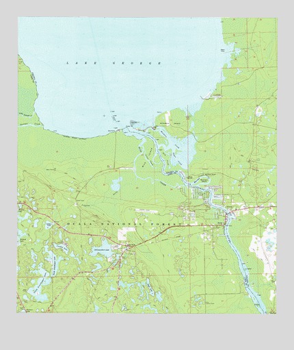
Astor, FL USGS Topographic Map
Click on map above to begin viewing in our Map Viewer.

This topographic map contains these locations and features:
Feature Name Type Latitude Longitude GNIS ID View Map
A and B Mobile Home ParkPopulated PlaceN29.1720°W81.5252°2447608View Map
AstorPopulated PlaceN29.1625°W81.5253°305223View Map
Astor Census Designated PlaceCensusN29.1635°W81.5349°2402654View Map
Astor Community CenterBuildingN29.1614°W81.5314°2380997View Map
Astor Lookout TowerTowerN29.1297°W81.5345°305224View Map
Astor ParkPopulated PlaceN29.1536°W81.5720°305225View Map
Astor Park CemeteryCemeteryN29.1558°W81.5756°2380992View Map
Astor Post OfficePost OfficeN29.1628°W81.5350°2380995View Map
Astor Public LibraryBuildingN29.1550°W81.5350°2380993View Map
Astor Recreation ParkParkN29.1542°W81.5356°2380994View Map
Astor Volunteer Fire Department (historical)BuildingN29.1697°W81.5454°2331100View Map
Axle CreekStreamN29.1958°W81.5562°305227View Map
Beakman Lake Recreation AreaParkN29.1305°W81.6192°306934View Map
Blairs Jungle Den Mobile Home ParkPopulated PlaceN29.1786°W81.5291°2447609View Map
Blue CreekStreamN29.2000°W81.5659°305335View Map
Blue IslandIslandN29.1903°W81.5640°305338View Map
BlufftonPopulated PlaceN29.1264°W81.5017°305349View Map
Boyd LakeLakeN29.1360°W81.5606°305365View Map
Camp McQuarrieLocaleN29.1550°W81.6015°305434View Map
Crooked LakeLakeN29.1528°W81.6029°305525View Map
Cross CreekChannelN29.1894°W81.5617°305528View Map
Falana IslandIslandN29.1286°W81.5087°305653View Map
First Baptist ChurchChurchN29.1619°W81.5294°2380996View Map
First Baptist Church of AstorChurchN29.1620°W81.5294°2447611View Map
Gobbler LakeLakeN29.1624°W81.6096°305731View Map
Hitchens CreekBayN29.1979°W81.5515°305813View Map
Hitchens IslandIslandN29.2064°W81.5490°305814View Map
Jones CoveBayN29.2356°W81.5264°305880View Map
Jumping GullyStreamN29.1825°W81.5670°305885View Map
Juniper CreekStreamN29.2039°W81.6123°305887View Map
Lake County Fire Rescue Station 10BuildingN29.1581°W81.5584°2331243View Map
Lake County Sheriff's Office - Astor SubstationBuildingN29.1630°W81.5245°2331478View Map
Lake County Sheriff's Office Astor SubstationBuildingN29.1627°W81.5433°2755971View Map
Little Juniper CreekStreamN29.2103°W81.6165°305960View Map
Lungren IslandIslandN29.1439°W81.5151°305995View Map
ManhattenPopulated PlaceN29.1386°W81.5159°304984View Map
Morrison BluffCliffN29.1833°W81.5312°306063View Map
Morrison CreekBendN29.1830°W81.5351°306064View Map
Morrison IslandIslandN29.1814°W81.5348°306066View Map
North Grasshopper LakeLakeN29.1473°W81.6073°306120View Map
Parramores Camp MarinaHarborN29.1830°W81.5329°2447606View Map
Payne CreekBayN29.1916°W81.5487°306205View Map
R Wightman GrantCivilN29.2336°W81.5109°306970View Map
Schimmerhorn LakeLakeN29.1519°W81.5835°306358View Map
Shell MoundSummitN29.1825°W81.5401°306377View Map
South Grasshopper LakeLakeN29.1373°W81.6135°306418View Map
South Moon Fish Camp MarinaHarborN29.1832°W81.5331°2447607View Map
VolusiaPopulated PlaceN29.1686°W81.5209°306545View Map
Volusia BarBarN29.2089°W81.5620°307803View Map
Volusia Bar Fish Camp MarinaHarborN29.2032°W81.5598°2451873View Map
Volusia Bar WharfLocaleN29.2022°W81.5831°307802View Map

Note: Coordinates in the location and feature list above are referenced to NAD83 datum.


Copyright (C) 2008-2025 Ryan Niemi / Sunset Dynamics ... All Rights Reserved