TopoQuest Logo
Do you find TopoQuest useful?
Help keep TopoQuest running and adding new maps/features by donating!
Bitcoin:  19c7KJd3qBynnjoSw5npx9KScwjBe4ifkT
Litecoin:  LXs6TkuXGGXo1vDsWCkWVdjQX94eUKd6ui
Home View Maps Find Maps Find Places Resources & Links


Sand Lake, Michigan Topographic Map

USGS Map Title: Sand Lake, MI
USGS Map MRC: 43085C5
DRG (GeoTIFF) Download: o43085c5.tif


Neighboring USGS Topographic Map Quads:


  Croton, MI  
43085D6
 

  Tift Corner, MI  
43085D5
 

  Howard City, MI  
43085D4
 

  Sand Lake SW, MI  
43085C6
 

  Sand Lake, MI  
43085C5
 

  Coral, MI  
43085C4
 

  Sparta, MI  
43085B6
 

  Cedar Springs, MI  
43085B5
 

  Evans, MI  
43085B4


Map MRC Location:

N44°
W86°
N44°
W85°
H8 H7 H6 H5 H4 H3 H2 H1
G8 G7 G6 G5 G4 G3 G2 G1
F8 F7 F6 F5 F4 F3 F2 F1
E8 E7 E6 E5 E4 E3 E2 E1
D8 D7 D6 D5 D4 D3 D2 D1
C8 C7 C6 C5 C4 C3 C2 C1
B8 B7 B6 B5 B4 B3 B2 B1
A8 A7 A6 A5 A4 A3 A2 A1
N43°
W86°
N43°
W85°

Sand Lake, MI USGS 1:24K Topographic Map Preview:
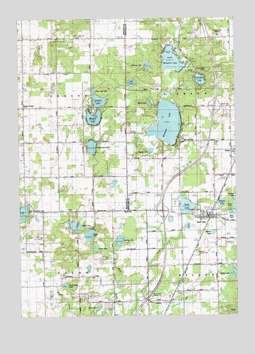
Sand Lake, MI USGS Topographic Map
Click on map above to begin viewing in our Map Viewer.

This topographic map contains these locations and features:
Feature Name Type Latitude Longitude GNIS ID View Map
Amazie LakeLakeN43.3197°W85.5489°1617066View Map
Baptist Church of Ensley CenterChurchN43.3372°W85.6247°2564558View Map
Baptist LakeLakeN43.3334°W85.5815°620564View Map
Baptist Lake SchoolSchoolN43.3378°W85.5848°620565View Map
Baptist Lake Township ParkParkN43.3369°W85.5819°2542010View Map
Bass LakeLakeN43.3490°W85.5199°620688View Map
Big Whitefish SchoolSchoolN43.3153°W85.5439°621368View Map
Blind LakeLakeN43.3393°W85.5495°621583View Map
Bradley LakeLakeN43.2993°W85.5008°621851View Map
Breford LakeLakeN43.2848°W85.5132°621918View Map
Briggs SchoolSchoolN43.2775°W85.6117°621983View Map
Butternut LakeLakeN43.3196°W85.5489°622394View Map
Conover LakeLakeN43.3405°W85.5787°623714View Map
Cook and White LakeLakeN43.2935°W85.6227°623730View Map
Crandall CemeteryCemeteryN43.2939°W85.5939°624001View Map
Crandall SchoolSchoolN43.3081°W85.5831°624004View Map
Englewright LakeLakeN43.3211°W85.5829°625600View Map
Ensley CenterPopulated PlaceN43.3378°W85.6228°625613View Map
Ensley Post Office (historical)Post OfficeN43.3667°W85.5600°2560144View Map
Fisk Lookout TowerTowerN43.2836°W85.6131°1623349View Map
Gidding LakeLakeN43.2819°W85.5675°626792View Map
Grove Post Office (historical)Post OfficeN43.3381°W85.6222°2541837View Map
Helena LakeLakeN43.2676°W85.5022°628064View Map
Hillman SchoolSchoolN43.3661°W85.6220°628317View Map
Interchange 110CrossingN43.2942°W85.5422°2566369View Map
Interchange 114CrossingN43.3378°W85.5114°2561847View Map
Kinney SchoolSchoolN43.3661°W85.5834°629742View Map
Little Bass LakeLakeN43.3531°W85.5153°630546View Map
Little Mud LakeLakeN43.3450°W85.5811°630697View Map
Little Whitefish LakeLakeN43.3571°W85.5360°630818View Map
Little Whitefish SchoolSchoolN43.3659°W85.5359°630819View Map
Lockwood DrainCanalN43.2539°W85.5403°2106560View Map
Lockwood Post Office (historical)Post OfficeN43.2569°W85.5375°2570720View Map
Lockwood Station (historical)LocaleN43.2569°W85.5375°2570792View Map
Lost LakeLakeN43.3481°W85.5594°631081View Map
Lower LakeLakeN43.2781°W85.5817°631175View Map
Mary Queen of Apostles ParishChurchN43.2931°W85.5172°2564552View Map
Middle LakeLakeN43.2841°W85.5850°632264View Map
Mill PondLakeN43.3720°W85.5295°632337View Map
Newcomb LakeLakeN43.3459°W85.5167°1617035View Map
No-Ko-Mos LakeLakeN43.2630°W85.5990°633440View Map
North Cedar Airport (historical)AirportN43.2577°W85.5470°1623827View Map
North Ensley CemeteryCemeteryN43.3672°W85.5936°633569View Map
North Kent Airpark (historical)AirportN43.2581°W85.6073°1623826View Map
Pangbron SchoolSchoolN43.3081°W85.6212°634334View Map
Pierson CemeteryCemeteryN43.3381°W85.5006°634842View Map
Pilgrim's Run Golf ClubLocaleN43.3472°W85.5625°2547787View Map
Reed LakeLakeN43.2539°W85.5804°635759View Map
Resurrection Lutheran ChurchChurchN43.2864°W85.5172°2564553View Map
Saint John CemeteryCemeteryN43.3664°W85.5970°636697View Map
Sand LakeLakeN43.2917°W85.5192°637184View Map
Sand LakePopulated PlaceN43.2920°W85.5178°1675442View Map
Sand Lake CemeteryCemeteryN43.2861°W85.5300°2567094View Map
Sand Lake Elementary SchoolSchoolN43.2897°W85.5203°2564557View Map
Sand Lake Fire Department Station 1BuildingN43.2927°W85.5166°2564551View Map
Sand Lake Police DepartmentBuildingN43.2928°W85.5167°2564556View Map
Sand Lake Post OfficePost OfficeN43.2928°W85.5181°2564555View Map
Sand Lake Station (historical)LocaleN43.2914°W85.5153°2564560View Map
Sand Lake United Methodist ChurchChurchN43.2931°W85.5186°2564554View Map
Sealey LakeLakeN43.2972°W85.5080°1617037View Map
South Ensley ChurchChurchN43.3086°W85.6231°638342View Map
South Ensley United Methodist ChurchChurchN43.3092°W85.6225°2548820View Map
Spangs County ParkParkN43.3500°W85.5244°2106633View Map
Spring PondLakeN43.3231°W85.5303°638607View Map
Township of EnsleyCivilN43.3377°W85.6225°1626243View Map
Township of PiersonCivilN43.3378°W85.5028°1626900View Map
Township of SolonCivilN43.2507°W85.6135°1627088View Map
Tri-County Area High SchoolSchoolN43.3681°W85.5094°2106632View Map
Upper LakeLakeN43.2878°W85.5931°1615406View Map
Village of Sand LakeCivilN43.2900°W85.5192°2399179View Map
Waltman LakeLakeN43.3553°W85.5508°2106634View Map
Ware LakeLakeN43.2932°W85.5015°636325View Map
White Creek Country Estates Mobile Home ParkPopulated PlaceN43.2550°W85.5750°2566625View Map
White Creek SchoolSchoolN43.2559°W85.5706°1616306View Map
Whitefish LakeLakeN43.3309°W85.5392°1616351View Map
Whitefish Lake Golf ClubLocaleN43.3261°W85.5292°2561584View Map
Wilds FieldAirportN43.2504°W85.5433°2650904View Map

Note: Coordinates in the location and feature list above are referenced to NAD83 datum.


Copyright (C) 2008-2025 Ryan Niemi / Sunset Dynamics ... All Rights Reserved