TopoQuest Logo
Do you find TopoQuest useful?
Help keep TopoQuest running and adding new maps/features by donating!
Bitcoin:  19c7KJd3qBynnjoSw5npx9KScwjBe4ifkT
Litecoin:  LXs6TkuXGGXo1vDsWCkWVdjQX94eUKd6ui
Home View Maps Find Maps Find Places Resources & Links


Sandersville, Georgia Topographic Map

USGS Map Title: Sandersville, GA
USGS Map MRC: 32082H7
DRG (GeoTIFF) Download: o32082h7.tif


Neighboring USGS Topographic Map Quads:


  Deepstep, GA  
33082A8
 

  Warthen, GA  
33082A7
 

  Downs, GA  
33082A6
 

  Tabernacle, GA  
32082H8
 

  Sandersville, GA  
32082H7
 

  Riddleville, GA  
32082H6
 

  Oconee, GA  
32082G8
 

  Irwins Crossroads, GA  
32082G7
 

  Harrison, GA  
32082G6


Map MRC Location:

N33°
W83°
N33°
W82°
H8 H7 H6 H5 H4 H3 H2 H1
G8 G7 G6 G5 G4 G3 G2 G1
F8 F7 F6 F5 F4 F3 F2 F1
E8 E7 E6 E5 E4 E3 E2 E1
D8 D7 D6 D5 D4 D3 D2 D1
C8 C7 C6 C5 C4 C3 C2 C1
B8 B7 B6 B5 B4 B3 B2 B1
A8 A7 A6 A5 A4 A3 A2 A1
N32°
W83°
N32°
W82°

Sandersville, GA USGS 1:24K Topographic Map Preview:
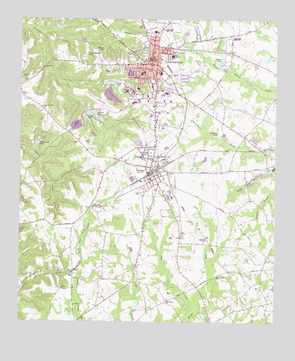
Sandersville, GA USGS Topographic Map
Click on map above to begin viewing in our Map Viewer.

This topographic map contains these locations and features:
Feature Name Type Latitude Longitude GNIS ID View Map
Anderson PondLakeN32.9519°W82.7782°310530View Map
Brownwood CemeteryCemeteryN32.9796°W82.8251°311903View Map
Cedar Meadow PondReservoirN32.9852°W82.8429°312488View Map
Church-Smith-Harris Streets Historic DistrictParkN32.9788°W82.8085°348300View Map
City of SandersvilleCivilN32.9827°W82.8093°2405415View Map
City of TennilleCivilN32.9359°W82.8135°2405579View Map
Cold CreekStreamN32.8777°W82.7915°312811View Map
Crawford SchoolSchoolN32.9432°W82.8154°355368View Map
Dixie Land LakeReservoirN32.9487°W82.8666°313495View Map
Dixie Land Lake DamDamN32.9477°W82.8671°340790View Map
Elder SchoolSchoolN32.9779°W82.8154°355665View Map
First Baptist ChurchChurchN32.9777°W82.8062°348315View Map
First Christian Church of SandersvilleChurchN32.9813°W82.8085°348316View Map
First Presbyterian ChurchChurchN32.9940°W82.8099°348317View Map
Georgia Grove ChurchChurchN32.8938°W82.7782°355997View Map
Grace Episcopal ChurchChurchN32.9843°W82.8110°348324View Map
Harrison PondReservoirN32.9876°W82.8342°315209View Map
Kaolin FieldAirportN32.9641°W82.8358°351892View Map
Kaolin Plaza Shopping CenterLocaleN32.9727°W82.8079°348341View Map
Kings PondReservoirN32.9591°W82.8428°316459View Map
Kings Pond DamDamN32.9604°W82.8432°340788View Map
Limestone ChurchChurchN32.9804°W82.8626°316878View Map
Lower Yarbrough LakeReservoirN32.9815°W82.7783°336361View Map
Lower Yarbrough Lake DamDamN32.9802°W82.7765°336360View Map
Marshall Grove ChurchChurchN32.9635°W82.8638°317724View Map
Memorial GardensCemeteryN32.9757°W82.8707°318019View Map
Memorial Hospital of Washington County HeliportAirportN32.9979°W82.8046°351893View Map
North Harris Street Historic DistrictParkN32.9904°W82.8101°348367View Map
Ohoopee CemeteryCemeteryN32.8890°W82.8549°348371View Map
Ohoopee ChurchChurchN32.8888°W82.8543°319928View Map
Ohoopee Volunteer Fire DepartmentBuildingN32.8826°W82.8044°2604133View Map
Pate CemeteryCemeteryN32.9365°W82.8343°348373View Map
Pete CemeteryCemeteryN32.9368°W82.8337°320404View Map
Phillips School (historical)SchoolN32.8927°W82.8340°348374View Map
Piney Mount CemeteryCemeteryN32.8840°W82.8032°348375View Map
Piney Mount ChurchChurchN32.8840°W82.8024°320733View Map
Political PondReservoirN32.9604°W82.8383°320981View Map
Political Pond DamDamN32.9624°W82.8399°340786View Map
Rawlings Sanitarium (historical)HospitalN32.9829°W82.8124°348381View Map
Saint Pauls African Methodist Episcopal ChurchChurchN32.9835°W82.8157°348389View Map
Saint Williams Roman Catholic ChurchChurchN32.9793°W82.8082°348390View Map
SandersvillePopulated PlaceN32.9815°W82.8101°322445View Map
Sandersville City CemeteryCemeteryN32.9824°W82.8151°348392View Map
Sandersville City HallBuildingN32.9838°W82.8115°348393View Map
Sandersville Elementary SchoolSchoolN32.9952°W82.8093°348394View Map
Sandersville Fire DepartmentBuildingN32.9840°W82.8130°2603686View Map
Sandersville Police DepartmentBuildingN32.9839°W82.8119°2733546View Map
Sandersville Post OfficePost OfficeN32.9840°W82.8107°348395View Map
Sandersville United Methodist ChurchChurchN32.9821°W82.8129°348396View Map
Segars PondReservoirN32.9835°W82.7767°322701View Map
Sinquefield CemeteryCemeteryN32.9229°W82.7965°348400View Map
Sisters CemeteryCemeteryN32.9874°W82.7726°348401View Map
Sisters ChurchChurchN32.9871°W82.7724°323044View Map
Smith PondReservoirN32.8816°W82.8176°340793View Map
Smith Pond DamDamN32.8802°W82.8182°340792View Map
Springfield Baptist ChurchChurchN32.9813°W82.8165°348407View Map
T J Elder Middle SchoolSchoolN32.9849°W82.8001°355661View Map
Tanyard BranchStreamN32.9960°W82.8660°348410View Map
Taylor LakeReservoirN32.9335°W82.8599°340616View Map
Taylor Lake DamDamN32.9335°W82.8599°340615View Map
TennillePopulated PlaceN32.9360°W82.8115°324005View Map
Tennille City HallBuildingN32.9368°W82.8118°348412View Map
Tennille City ParkParkN32.9371°W82.8126°348413View Map
Tennille Elementary SchoolSchoolN32.9340°W82.8112°348414View Map
Tennille Fire DepartmentBuildingN32.9370°W82.8121°2603556View Map
Tennille Police DepartmentBuildingN32.9372°W82.8112°2733538View Map
Tennille Post OfficePost OfficeN32.9363°W82.8126°348415View Map
Thiele Kaolin Mining Company LakeReservoirN32.9691°W82.8317°340795View Map
Thiele Kaolin Mining Company Lake DamDamN32.9718°W82.8332°340794View Map
Twin Cities Plaza Shopping CenterLocaleN32.9568°W82.8096°348418View Map
Union Hill ChurchChurchN32.8813°W82.8476°324570View Map
Upper Yarbrough LakeReservoirN32.9835°W82.7767°340093View Map
Upper Yarbrough Lake DamDamN32.9818°W82.7765°340092View Map
Washington CountyCivilN32.9695°W82.7959°348428View Map
Washington County CourthouseBuildingN32.9835°W82.8115°348429View Map
Washington County High SchoolSchoolN32.9693°W82.8037°348430View Map
Washington County JailBuildingN32.9609°W82.8358°348431View Map
Washington County Regional Medical CenterHospitalN32.9958°W82.8041°348353View Map
Washington County Sheriff's OfficeBuildingN32.9610°W82.8360°2733945View Map
Washington Institute (historical)SchoolN32.9779°W82.8207°348432View Map
WSNT-AM (Sandersville)TowerN32.9732°W82.8093°352538View Map
WSNT-FM (Sandersville)TowerN32.9732°W82.8093°352767View Map
Zeta CemeteryCemeteryN32.9282°W82.8171°325663View Map

Note: Coordinates in the location and feature list above are referenced to NAD83 datum.


Copyright (C) 2008-2025 Ryan Niemi / Sunset Dynamics ... All Rights Reserved