TopoQuest Logo
Do you find TopoQuest useful?
Help keep TopoQuest running and adding new maps/features by donating!
Bitcoin:  19c7KJd3qBynnjoSw5npx9KScwjBe4ifkT
Litecoin:  LXs6TkuXGGXo1vDsWCkWVdjQX94eUKd6ui
Home View Maps Find Maps Find Places Resources & Links


Oconee, Georgia Topographic Map

USGS Map Title: Oconee, GA
USGS Map MRC: 32082G8
DRG (GeoTIFF) Download: o32082g8.tif


Neighboring USGS Topographic Map Quads:


  Gumm Pond, GA  
32083H1
 

  Tabernacle, GA  
32082H8
 

  Sandersville, GA  
32082H7
 

  Toomsboro, GA  
32083G1
 

  Oconee, GA  
32082G8
 

  Irwins Crossroads, GA  
32082G7
 

  Nicklesville, GA  
32083F1
 

  Cow Hell Swamp, GA  
32082F8
 

  Lovett, GA  
32082F7


Map MRC Location:

N33°
W83°
N33°
W82°
H8 H7 H6 H5 H4 H3 H2 H1
G8 G7 G6 G5 G4 G3 G2 G1
F8 F7 F6 F5 F4 F3 F2 F1
E8 E7 E6 E5 E4 E3 E2 E1
D8 D7 D6 D5 D4 D3 D2 D1
C8 C7 C6 C5 C4 C3 C2 C1
B8 B7 B6 B5 B4 B3 B2 B1
A8 A7 A6 A5 A4 A3 A2 A1
N32°
W83°
N32°
W82°

Oconee, GA USGS 1:24K Topographic Map Preview:
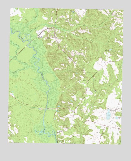
Oconee, GA USGS Topographic Map
Click on map above to begin viewing in our Map Viewer.

This topographic map contains these locations and features:
Feature Name Type Latitude Longitude GNIS ID View Map
Antioch CemeteryCemeteryN32.8435°W82.9468°348285View Map
Antioch ChurchChurchN32.8432°W82.9454°354344View Map
Avant CemeteryCemeteryN32.8588°W82.8887°310681View Map
Balls Ferry (historical)CrossingN32.7818°W82.9585°348287View Map
Balls Ferry BridgeBridgeN32.7818°W82.9582°310768View Map
Bay BranchStreamN32.8113°W82.9618°310881View Map
Bay Branch CemeteryCemeteryN32.8085°W82.9138°310884View Map
Bay Spring ChurchChurchN32.8182°W82.9182°354490View Map
Bay Springs CemeteryCemeteryN32.8177°W82.9188°348288View Map
Briley BranchStreamN32.8554°W82.9399°348293View Map
Buckhorn BranchStreamN32.8204°W82.9751°311979View Map
Buffalo CreekStreamN32.8471°W82.9871°311994View Map
Carter CemeteryCemeteryN32.8202°W82.9199°352313View Map
City of OconeeCivilN32.8535°W82.9577°2404419View Map
Commissioner CreekStreamN32.8179°W82.9676°327502View Map
Crafton Springs BranchStreamN32.8429°W82.8932°348303View Map
Davis PondLakeN32.7521°W82.9416°313359View Map
Dead RiverStreamN32.7593°W82.9601°313386View Map
Fuqua PondReservoirN32.8723°W82.9303°314462View Map
GardnerPopulated PlaceN32.8535°W82.9626°331790View Map
Gardners Grove Church of GodChurchN32.8488°W82.9504°348321View Map
Gilbert PondLakeN32.7748°W82.8802°314593View Map
HazardPopulated PlaceN32.8704°W82.8865°331941View Map
Herds PondReservoirN32.7773°W82.8895°315338View Map
Hodges Hill ChurchChurchN32.8735°W82.9479°315489View Map
Hodges New PondLakeN32.8376°W82.8887°315491View Map
Hodges PondLakeN32.7989°W82.9045°315492View Map
Little PondLakeN32.7818°W82.8888°317149View Map
Little Sandy Hill CreekStreamN32.8546°W82.9335°317187View Map
Martin CemeteryCemeteryN32.7602°W82.8865°317738View Map
McGowan BranchStreamN32.7860°W82.9871°317920View Map
Mikes Mill CreekStreamN32.8593°W82.9229°348355View Map
OconeePopulated PlaceN32.8554°W82.9499°332556View Map
Oconee Church of GodChurchN32.8660°W82.9468°348370View Map
Oconee Police DepartmentBuildingN32.8566°W82.9590°2734142View Map
Oconee Volunteer Fire DepartmentBuildingN32.8566°W82.9591°2604748View Map
Oochee CreekStreamN32.7804°W82.9590°320072View Map
Red Field CemeteryCemeteryN32.7827°W82.8915°321374View Map
Rocky BranchStreamN32.7974°W82.9413°348386View Map
Samuel Grove ChurchChurchN32.8068°W82.9126°322397View Map
Sandy Hill CreekStreamN32.8502°W82.9768°322486View Map
Spring LakeStreamN32.8563°W82.9988°323444View Map
Tennille DivisionCivilN32.8689°W82.8762°1936579View Map
Uchee BranchStreamN32.8038°W82.9326°348419View Map
VealPopulated PlaceN32.7793°W82.9274°348422View Map
Veal PondReservoirN32.7800°W82.9456°324676View Map
Veal PondReservoirN32.7845°W82.9442°324677View Map
Wesley ChapelChurchN32.7593°W82.8960°325012View Map
Woods CemeteryCemeteryN32.8504°W82.8951°325547View Map
Woods CemeteryCemeteryN32.8682°W82.9415°325548View Map
Zion Hope ChurchChurchN32.7924°W82.8765°325713View Map

Note: Coordinates in the location and feature list above are referenced to NAD83 datum.


Copyright (C) 2008-2025 Ryan Niemi / Sunset Dynamics ... All Rights Reserved