TopoQuest Logo
Do you find TopoQuest useful?
Help keep TopoQuest running and adding new maps/features by donating!
Bitcoin:  19c7KJd3qBynnjoSw5npx9KScwjBe4ifkT
Litecoin:  LXs6TkuXGGXo1vDsWCkWVdjQX94eUKd6ui
Home View Maps Find Maps Find Places Resources & Links


Downs, Georgia Topographic Map

USGS Map Title: Downs, GA
USGS Map MRC: 33082A6
DRG (GeoTIFF) Download: o33082a6.tif


Neighboring USGS Topographic Map Quads:


  Warthen NE, GA  
33082B7
 

  Mitchell, GA  
33082B6
 

  Gibson, GA  
33082B5
 

  Warthen, GA  
33082A7
 

  Downs, GA  
33082A6
 

  Grange, GA  
33082A5
 

  Sandersville, GA  
32082H7
 

  Riddleville, GA  
32082H6
 

  Davisboro, GA  
32082H5


Map MRC Location:

N34°
W83°
N34°
W82°
H8 H7 H6 H5 H4 H3 H2 H1
G8 G7 G6 G5 G4 G3 G2 G1
F8 F7 F6 F5 F4 F3 F2 F1
E8 E7 E6 E5 E4 E3 E2 E1
D8 D7 D6 D5 D4 D3 D2 D1
C8 C7 C6 C5 C4 C3 C2 C1
B8 B7 B6 B5 B4 B3 B2 B1
A8 A7 A6 A5 A4 A3 A2 A1
N33°
W83°
N33°
W82°

Downs, GA USGS 1:24K Topographic Map Preview:
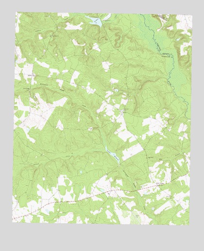
Downs, GA USGS Topographic Map
Click on map above to begin viewing in our Map Viewer.

This topographic map contains these locations and features:
Feature Name Type Latitude Longitude GNIS ID View Map
Amerson CemeteryCemeteryN33.0810°W82.7010°348283View Map
Antioch Baptist ChurchChurchN33.1229°W82.7257°354349View Map
Antioch CemeteryCemeteryN33.1226°W82.7260°348286View Map
Archers Lake DamDamN33.1201°W82.6885°336382View Map
Archers LakesReservoirN33.1204°W82.6932°310603View Map
Brown LakeReservoirN33.0798°W82.6776°340618View Map
Brown Lake DamDamN33.0785°W82.6765°340617View Map
Chickasawhatchie BridgeBridgeN33.0199°W82.6637°348299View Map
DownsPopulated PlaceN33.0663°W82.6735°326249View Map
Downs Baptist ChurchChurchN33.0679°W82.6746°348310View Map
Downs CemeteryCemeteryN33.0676°W82.6743°348311View Map
Gordon CemeteryCemeteryN33.0221°W82.7390°348323View Map
Hall School (historical)SchoolN33.0240°W82.6474°348325View Map
Halls ChapelChurchN33.0232°W82.6476°356145View Map
Halls Cross Roads CemeteryCemeteryN33.0232°W82.6476°348326View Map
Halls CrossingPopulated PlaceN33.0240°W82.6474°331898View Map
Heidrich Airport (historical)AirportN33.0043°W82.6624°348332View Map
Holly Spring ChurchChurchN33.1113°W82.7240°315566View Map
Inman BranchStreamN33.0018°W82.6485°315924View Map
John Sparks CemeteryCemeteryN33.0882°W82.7371°348336View Map
Jordan ChurchChurchN33.0168°W82.6379°316269View Map
Jordan Mill Pond DamDamN33.0413°W82.6799°336376View Map
Jordan MillpondReservoirN33.0413°W82.6794°336377View Map
Jordans Mill (historical)LocaleN33.0357°W82.6749°348338View Map
Kittrell CreekStreamN33.0440°W82.6849°316486View Map
May Branch ChurchChurchN33.0399°W82.6546°317812View Map
May Branch School (historical)SchoolN33.0399°W82.6551°348348View Map
Minton Springs ChurchChurchN33.0790°W82.7393°318326View Map
Oak Grove CemeteryCemeteryN33.0251°W82.7379°348369View Map
SparksPopulated PlaceN33.0879°W82.7376°326525View Map
Spring Hill Church (historical)ChurchN33.0888°W82.6671°348406View Map
Union Church (historical)ChurchN33.0129°W82.7157°348421View Map
White Oak ChurchChurchN33.0677°W82.6718°325168View Map
Whiteoak CemeteryCemeteryN33.0676°W82.6718°348434View Map

Note: Coordinates in the location and feature list above are referenced to NAD83 datum.


Copyright (C) 2008-2025 Ryan Niemi / Sunset Dynamics ... All Rights Reserved