TopoQuest Logo
Do you find TopoQuest useful?
Help keep TopoQuest running and adding new maps/features by donating!
Bitcoin:  19c7KJd3qBynnjoSw5npx9KScwjBe4ifkT
Litecoin:  LXs6TkuXGGXo1vDsWCkWVdjQX94eUKd6ui
Home View Maps Find Maps Find Places Resources & Links


Santeetlah Creek, North Carolina Topographic Map

USGS Map Title: Santeetlah Creek, NC
USGS Map MRC: 35083C8
DRG (GeoTIFF) Download: o35083c8.tif


Neighboring USGS Topographic Map Quads:


  Whiteoak Flats, TN  
35084D1
 

  Tapoco, NC  
35083D8
 

  Fontana Dam, NC  
35083D7
 

  Big Junction, TN  
35084C1
 

  Santeetlah Creek, NC  
35083C8
 

  Robbinsville, NC  
35083C7
 

  McDaniel Bald, NC  
35084B1
 

  Marble, NC  
35083B8
 

  Andrews, NC  
35083B7


Map MRC Location:

N36°
W84°
N36°
W83°
H8 H7 H6 H5 H4 H3 H2 H1
G8 G7 G6 G5 G4 G3 G2 G1
F8 F7 F6 F5 F4 F3 F2 F1
E8 E7 E6 E5 E4 E3 E2 E1
D8 D7 D6 D5 D4 D3 D2 D1
C8 C7 C6 C5 C4 C3 C2 C1
B8 B7 B6 B5 B4 B3 B2 B1
A8 A7 A6 A5 A4 A3 A2 A1
N35°
W84°
N35°
W83°

Santeetlah Creek, NC USGS 1:24K Topographic Map Preview:
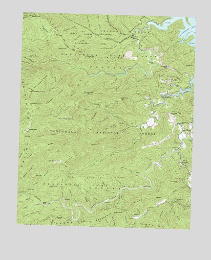
Santeetlah Creek, NC USGS Topographic Map
Click on map above to begin viewing in our Map Viewer.

This topographic map contains these locations and features:
Feature Name Type Latitude Longitude GNIS ID View Map
Adamcamp BranchStreamN35.3659°W83.9521°1008652View Map
Ammons CoveValleyN35.2887°W83.8963°1008711View Map
Art Stewart RidgeRidgeN35.3220°W83.9788°1008781View Map
Avey CreekStreamN35.3718°W83.9082°1008822View Map
Axe GapGapN35.2681°W83.9007°1008823View Map
Axe RidgeRidgeN35.2526°W83.8960°1008824View Map
Axefield BranchStreamN35.2570°W83.9107°1008825View Map
Bear CreekStreamN35.2634°W83.8882°1008996View Map
Bearden BranchStreamN35.3165°W83.9352°1009010View Map
Bee KnobsSummitN35.2887°W83.9644°1019045View Map
Belding House BranchStreamN35.2704°W83.9282°1009157View Map
Big FallsFallsN35.2656°W83.9660°1009313View Map
Big KnobSummitN35.2790°W83.9866°1019142View Map
Boardcamp BranchStreamN35.2515°W83.9169°1009509View Map
Burntrock RidgeRidgeN35.2581°W83.9827°1009854View Map
Cal CoveValleyN35.2879°W83.8818°1009901View Map
Cedar Cliff ChurchChurchN35.3279°W83.8971°1010117View Map
Cedar CoveValleyN35.3392°W83.9281°1010122View Map
Cedar CreekStreamN35.3243°W83.9055°1010125View Map
Cedar TopSummitN35.3256°W83.9274°1010138View Map
Charikus BranchStreamN35.3556°W83.8763°1010170View Map
Chestnut Flat BranchStreamN35.2826°W83.9096°1010240View Map
Cold BranchStreamN35.3459°W83.9891°1010373View Map
Daviscamp BranchStreamN35.3656°W83.9516°1010696View Map
Deep GapGapN35.2601°W83.9255°1010736View Map
Deep GapGapN35.2793°W83.9638°1010739View Map
Deerlick BranchStreamN35.2734°W83.9238°1010771View Map
Deerlick RidgeRidgeN35.2798°W83.9357°1010772View Map
DentonsPopulated PlaceN35.2573°W83.9124°1019953View Map
Dick BranchStreamN35.3062°W83.8835°1010803View Map
Doc Stewart RidgeRidgeN35.3323°W83.9863°1010840View Map
Dogfall BranchStreamN35.3187°W83.9435°1010860View Map
Duncan BranchStreamN35.3398°W83.8771°1010941View Map
Fall BranchStreamN35.2551°W83.9707°1011156View Map
Farley CoveValleyN35.3609°W83.8889°1011177View Map
Firescald RidgeRidgeN35.2698°W83.9544°1011222View Map
Flat BranchStreamN35.2609°W83.8880°1011244View Map
Flat BranchStreamN35.2670°W83.9891°1011248View Map
Fork RidgeRidgeN35.3034°W83.9446°1011325View Map
Funnel TopSummitN35.3473°W83.8818°1020382View Map
Goldie DeadenLocaleN35.3551°W83.9691°1011554View Map
Grassy BranchStreamN35.3631°W83.9468°1011622View Map
Groundhog BranchStreamN35.3687°W83.9588°1011757View Map
Hard Slate GapGapN35.3179°W83.8913°1011851View Map
Hooper BaldSummitN35.3059°W83.9941°1020822View Map
Hooper CoveValleyN35.3406°W83.9097°1012160View Map
Hooper Mill CreekStreamN35.3095°W83.9124°1012161View Map
Horse CoveValleyN35.3652°W83.9197°1012189View Map
Horse Cove CampgroundLocaleN35.3648°W83.9199°1018197View Map
Horse Cove RidgeRidgeN35.3487°W83.9477°1012193View Map
Horsecove BranchStreamN35.3656°W83.9191°1012210View Map
Huckleberry KnobSummitN35.3220°W83.9935°1020854View Map
Indian CreekStreamN35.3451°W83.9655°1012334View Map
Indian Spring BranchStreamN35.3623°W83.9435°1012352View Map
Indiancamp BranchStreamN35.2634°W83.9574°1012353View Map
Jess Teeseteska Land TractAreaN35.2895°W83.8813°1018033View Map
Joyce Kilmer MemorialParkN35.3556°W83.9341°1012570View Map
Joyce Kilmer Picnic AreaLocaleN35.3590°W83.9313°1018200View Map
JunctionPopulated PlaceN35.2651°W83.9377°1021005View Map
King MeadowsFlatN35.2873°W83.9735°1012632View Map
Lige BranchStreamN35.2762°W83.8768°1012868View Map
Little Buffalo CreekStreamN35.2951°W83.9257°1012924View Map
Little CreekStreamN35.3115°W83.9232°1012938View Map
Little Huckleberry KnobSummitN35.3298°W83.9921°1012978View Map
Little Santeetlah CreekStreamN35.3623°W83.9196°1013029View Map
Little Snowbird CreekStreamN35.2968°W83.8852°1013031View Map
Littleflat BranchStreamN35.2626°W83.9832°1013049View Map
Lovin BranchStreamN35.2937°W83.8896°1013216View Map
McGuiresPopulated PlaceN35.3023°W83.9957°1021393View Map
Meadow BranchStreamN35.2726°W83.9894°1013449View Map
Middle FallsFallsN35.2623°W83.9810°1013492View Map
Mount Nebo ChurchChurchN35.3118°W83.8857°1013753View Map
Mouse KnobSummitN35.2734°W83.9769°1021578View Map
Mouse Knob BranchStreamN35.2665°W83.9671°1013811View Map
Obadiah CoveValleyN35.3112°W83.9296°1014071View Map
Obadiah GapGapN35.3504°W83.9538°1014072View Map
Owlcamp BranchStreamN35.2643°W83.9402°1014162View Map
Pantherflat BranchStreamN35.2687°W83.9930°1014219View Map
Patrick MeadowsFlatN35.3129°W83.9691°1014248View Map
Polecat BranchStreamN35.2884°W83.9032°1014558View Map
Poplar CoveValleyN35.3582°W83.9313°1014579View Map
Queen RidgeRidgeN35.2954°W83.9874°1014686View Map
Rattler FordCrossingN35.3479°W83.9041°1022149View Map
Rattler Ford CampgroundLocaleN35.3590°W83.9163°1018199View Map
Rockbar BranchStreamN35.2765°W83.9963°1015004View Map
Sand CreekStreamN35.3481°W83.9763°1015217View Map
Santeetlah CreekStreamN35.3415°W83.9999°1015249View Map
Santeetlah GapGapN35.3454°W83.8941°1015250View Map
Santeetlah Hunt Shelter CampLocaleN35.3406°W83.9332°1018202View Map
Sassafras CreekStreamN35.2545°W83.9596°1015268View Map
Sassafras FallsFallsN35.2556°W83.9677°1015269View Map
Sassafras RidgeRidgeN35.2534°W83.9446°1015282View Map
Seven Springs BranchStreamN35.3190°W83.9424°1015363View Map
Seven Springs GapGapN35.3279°W83.9507°1015364View Map
Shute CoveValleyN35.3393°W83.9289°1015508View Map
Skeekah CoveValleyN35.3087°W83.9223°1015560View Map
Snowbird SchoolSchoolN35.3012°W83.8827°1015653View Map
South Fork Squally CreekStreamN35.2998°W83.9621°1015696View Map
Squally CreekStreamN35.2954°W83.9257°1015764View Map
Stewart CabinLocaleN35.3406°W83.9366°1018201View Map
Stratton BaldSummitN35.3734°W83.9930°1022813View Map
Tecoatlah 364,482 Land TractAreaN35.3379°W83.8941°1018035View Map
Teeoatlah BranchStreamN35.3334°W83.8857°1016061View Map
Tom Kalonuheska Land TractAreaN35.3070°W83.8780°1018034View Map
Upper FallsFallsN35.2709°W83.9927°1016335View Map
Wilcat BranchStreamN35.2709°W83.9263°1016657View Map
Wildcat KnobSummitN35.2581°W83.9302°1023242View Map
Willie KnobSummitN35.2787°W83.8849°1023262View Map
Wilson CabinLocaleN35.2743°W83.9096°1016717View Map
Wolf Laurel BasinBasinN35.3643°W83.9841°1016778View Map
Wolf Laurel BranchStreamN35.3515°W83.9807°1016779View Map
Wright CreekStreamN35.3395°W83.9457°1016846View Map

Note: Coordinates in the location and feature list above are referenced to NAD83 datum.


Copyright (C) 2008-2024 Ryan Niemi / Sunset Dynamics ... All Rights Reserved