TopoQuest Logo
Do you find TopoQuest useful?
Help keep TopoQuest running and adding new maps/features by donating!
Bitcoin:  19c7KJd3qBynnjoSw5npx9KScwjBe4ifkT
Litecoin:  LXs6TkuXGGXo1vDsWCkWVdjQX94eUKd6ui
Home View Maps Find Maps Find Places Resources & Links


Sardis, Georgia Topographic Map

USGS Map Title: Sardis, GA
USGS Map MRC: 32081H7
DRG (GeoTIFF) Download: o32081h7.tif


Neighboring USGS Topographic Map Quads:


  Idlewood, GA  
33081A8
 

  Alexander, GA  
33081A7
 

  Girard, GA  
33081A6
 

  Perkins, GA  
32081H8
 

  Sardis, GA  
32081H7
 

  Hilltonia, GA  
32081H6
 

  Millen, GA  
32081G8
 

  Bay Branch, GA  
32081G7
 

  Sylvania North, GA  
32081G6


Map MRC Location:

N33°
W82°
N33°
W81°
H8 H7 H6 H5 H4 H3 H2 H1
G8 G7 G6 G5 G4 G3 G2 G1
F8 F7 F6 F5 F4 F3 F2 F1
E8 E7 E6 E5 E4 E3 E2 E1
D8 D7 D6 D5 D4 D3 D2 D1
C8 C7 C6 C5 C4 C3 C2 C1
B8 B7 B6 B5 B4 B3 B2 B1
A8 A7 A6 A5 A4 A3 A2 A1
N32°
W82°
N32°
W81°

Sardis, GA USGS 1:24K Topographic Map Preview:
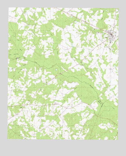
Sardis, GA USGS Topographic Map
Click on map above to begin viewing in our Map Viewer.

This topographic map contains these locations and features:
Feature Name Type Latitude Longitude GNIS ID View Map
Bee Tree BranchStreamN32.9488°W81.8482°311026View Map
Beech Branch Baptist Church (historical)ChurchN32.9799°W81.7782°347935View Map
Beech Branch CemeteryCemeteryN32.9802°W81.7784°311027View Map
Beech Branch School (historical)SchoolN32.9796°W81.7782°334808View Map
Bill Davis (historical)Populated PlaceN32.9965°W81.8115°334809View Map
Burke County Emergency Management Agency Engine Company 12BuildingN32.9778°W81.7636°2604222View Map
City of SardisCivilN32.9756°W81.7621°2405425View Map
Cousins Elementary SchoolSchoolN32.9788°W81.7643°347963View Map
Dry BranchStreamN32.9279°W81.7854°313641View Map
Dry Branch ChurchChurchN32.9088°W81.8209°313654View Map
Dry Branch School (historical)SchoolN32.9088°W81.8221°342977View Map
East Burke ChurchChurchN32.9952°W81.8087°347973View Map
Ellis Chapel CemeteryCemeteryN32.8907°W81.7534°313923View Map
Looks BranchStreamN32.9538°W81.8579°317404View Map
Lovett BranchStreamN32.9235°W81.7773°317447View Map
New McCoy ChurchChurchN32.9460°W81.7909°319477View Map
Old McCoy ChurchChurchN32.9279°W81.8318°319996View Map
Old SardisPopulated PlaceN32.9632°W81.7623°334813View Map
Pleasant Grove School (historical)SchoolN32.9482°W81.7687°334814View Map
SardisPopulated PlaceN32.9752°W81.7576°322525View Map
Sardis Branch LibraryBuildingN32.9760°W81.7593°348053View Map
Sardis CemeteryCemeteryN32.9768°W81.7740°322530View Map
Sardis DivisionCivilN32.9793°W81.7857°1936528View Map
Sardis Police DepartmentBuildingN32.9683°W81.7593°2733928View Map
Sardis Post OfficePost OfficeN32.9766°W81.7623°348054View Map
Sardis Town HallBuildingN32.9746°W81.7568°348055View Map
Slough BranchStreamN32.9463°W81.8201°323087View Map

Note: Coordinates in the location and feature list above are referenced to NAD83 datum.


Copyright (C) 2008-2024 Ryan Niemi / Sunset Dynamics ... All Rights Reserved