TopoQuest Logo
Do you find TopoQuest useful?
Help keep TopoQuest running and adding new maps/features by donating!
Bitcoin:  19c7KJd3qBynnjoSw5npx9KScwjBe4ifkT
Litecoin:  LXs6TkuXGGXo1vDsWCkWVdjQX94eUKd6ui
Home View Maps Find Maps Find Places Resources & Links


Perkins, Georgia Topographic Map

USGS Map Title: Perkins, GA
USGS Map MRC: 32081H8
DRG (GeoTIFF) Download: o32081h8.tif


Neighboring USGS Topographic Map Quads:


  Waynesboro, GA  
33082A1
 

  Idlewood, GA  
33081A8
 

  Alexander, GA  
33081A7
 

  Bellevue, GA  
32082H1
 

  Perkins, GA  
32081H8
 

  Sardis, GA  
32081H7
 

  Birdsville, GA  
32082G1
 

  Millen, GA  
32081G8
 

  Bay Branch, GA  
32081G7


Map MRC Location:

N33°
W82°
N33°
W81°
H8 H7 H6 H5 H4 H3 H2 H1
G8 G7 G6 G5 G4 G3 G2 G1
F8 F7 F6 F5 F4 F3 F2 F1
E8 E7 E6 E5 E4 E3 E2 E1
D8 D7 D6 D5 D4 D3 D2 D1
C8 C7 C6 C5 C4 C3 C2 C1
B8 B7 B6 B5 B4 B3 B2 B1
A8 A7 A6 A5 A4 A3 A2 A1
N32°
W82°
N32°
W81°

Perkins, GA USGS 1:24K Topographic Map Preview:
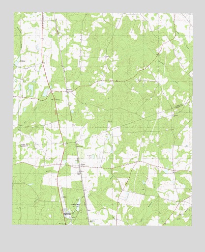
Perkins, GA USGS Topographic Map
Click on map above to begin viewing in our Map Viewer.

This topographic map contains these locations and features:
Feature Name Type Latitude Longitude GNIS ID View Map
Bardman Grove ChurchChurchN32.9213°W81.9548°310793View Map
Bo Ginn National Fish Hatchery and AquariumParkN32.8811°W81.9609°2765208View Map
Brinson MillpondReservoirN32.9710°W81.9972°354858View Map
Brinson Millpond DamDamN32.9690°W81.9985°341637View Map
Burke County Emergency Management Agency Engine Company 9BuildingN32.9534°W81.9723°2604270View Map
Burton School (historical)SchoolN32.9615°W81.9134°334810View Map
Cullen CemeteryCemeteryN32.9607°W81.9126°313207View Map
Cullen School (historical)SchoolN32.9435°W81.9223°334811View Map
Cullins School (historical)SchoolN32.9410°W81.9146°347966View Map
Fellowship ChurchChurchN32.9485°W81.9712°314098View Map
Florence Church (historical)ChurchN32.9615°W81.9176°347982View Map
Florence School (historical)SchoolN32.9718°W81.9026°334812View Map
Green Fork CemeteryCemeteryN32.9074°W81.8882°342982View Map
Green Fork ChurchChurchN32.9068°W81.8879°356094View Map
Habersham (historical)Populated PlaceN32.9404°W81.8893°342983View Map
Habersham CemeteryCemeteryN32.9399°W81.8884°342984View Map
Habersham ChurchChurchN32.9402°W81.8884°356131View Map
Habersham School (historical)SchoolN32.9402°W81.8884°334857View Map
Jackson PondLakeN32.9157°W81.9437°316019View Map
Jenkins LakeReservoirN32.9529°W81.9774°337248View Map
Jenkins Lake DamDamN32.9502°W81.9782°337247View Map
Lawtonville CemeteryCemeteryN32.8771°W81.9457°316705View Map
Magnolia CemeteryCemeteryN32.9063°W81.9534°342996View Map
Magnolia ChurchChurchN32.9065°W81.9532°317611View Map
Magnolia SpringSpringN32.8793°W81.9582°334862View Map
Magnolia Springs State ParkParkN32.8868°W81.9557°317625View Map
Magnolia Springs State Park DamDamN32.8852°W81.9548°341010View Map
Magnolia Springs State Park LakeReservoirN32.8870°W81.9537°341011View Map
Magnolia View LakeReservoirN32.9060°W81.9753°340295View Map
Magnolia View Lake DamDamN32.9052°W81.9798°340294View Map
McCullen TempleChurchN32.9363°W81.9329°317883View Map
Millen AirportAirportN32.8923°W81.9663°351848View Map
Millen National Fish HatcheryLocaleN32.8827°W81.9615°344295View Map
MunnerlynPopulated PlaceN32.9535°W81.9621°326412View Map
PerkinsPopulated PlaceN32.9096°W81.9529°332641View Map
Perkins Census Designated PlaceCensusN32.9149°W81.9490°2587044View Map
Perkins Post OfficePost OfficeN32.9090°W81.9537°352136View Map
Rock BranchStreamN32.8804°W81.9065°321712View Map
Rock Branch ChurchChurchN32.8821°W81.8832°321714View Map
Rocky Branch CemeteryCemeteryN32.8815°W81.8832°343004View Map
Union School (historical)SchoolN32.9288°W81.8846°334868View Map
Wards Grove ChurchChurchN32.9743°W81.9357°324841View Map
Wilsons StorePopulated PlaceN32.9538°W81.9735°348089View Map
Wood PondReservoirN32.9560°W81.9061°341566View Map
Wood Pond DamDamN32.9568°W81.9065°341565View Map

Note: Coordinates in the location and feature list above are referenced to NAD83 datum.


Copyright (C) 2008-2024 Ryan Niemi / Sunset Dynamics ... All Rights Reserved