TopoQuest Logo
Do you find TopoQuest useful?
Help keep TopoQuest running and adding new maps/features by donating!
Bitcoin:  19c7KJd3qBynnjoSw5npx9KScwjBe4ifkT
Litecoin:  LXs6TkuXGGXo1vDsWCkWVdjQX94eUKd6ui
Home View Maps Find Maps Find Places Resources & Links


Sardis Dam, Mississippi Topographic Map

USGS Map Title: Sardis Dam, MS
USGS Map MRC: 34089D7
DRG (GeoTIFF) Download: o34089d7.tif


Neighboring USGS Topographic Map Quads:


  Senatobia, MS  
34089E8
 

  Looxahoma, MS  
34089E7
 

  Tyro, MS  
34089E6
 

  Sardis, MS  
34089D8
 

  Sardis Dam, MS  
34089D7
 

  Coles Point, MS  
34089D6
 

  Batesville, MS  
34089C8
 

  Sardis SE, MS  
34089C7
 

  Splinter, MS  
34089C6


Map MRC Location:

N35°
W90°
N35°
W89°
H8 H7 H6 H5 H4 H3 H2 H1
G8 G7 G6 G5 G4 G3 G2 G1
F8 F7 F6 F5 F4 F3 F2 F1
E8 E7 E6 E5 E4 E3 E2 E1
D8 D7 D6 D5 D4 D3 D2 D1
C8 C7 C6 C5 C4 C3 C2 C1
B8 B7 B6 B5 B4 B3 B2 B1
A8 A7 A6 A5 A4 A3 A2 A1
N34°
W90°
N34°
W89°

Sardis Dam, MS USGS 1:24K Topographic Map Preview:
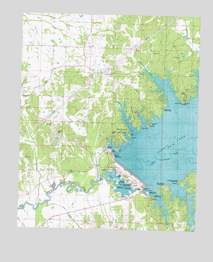
Sardis Dam, MS USGS Topographic Map
Click on map above to begin viewing in our Map Viewer.

This topographic map contains these locations and features:
Feature Name Type Latitude Longitude GNIS ID View Map
Beach Point Public Use AreaParkN34.4182°W89.8090°685636View Map
Belmont CemeteryCemeteryN34.4159°W89.8712°685637View Map
Black Jack PointCapeN34.4015°W89.7723°667226View Map
Black Jack Point Public Use AreaParkN34.4001°W89.7723°685640View Map
Blakely SchoolSchoolN34.3782°W89.8579°667264View Map
Bratton StoreLocaleN34.4348°W89.8509°685642View Map
Cemetery RidgeRidgeN34.4379°W89.7929°668224View Map
Clarendon CreekStreamN34.4029°W89.8193°668500View Map
Clear SpringsSpringN34.4079°W89.8370°685655View Map
Cold Springs CemeteryCemeteryN34.3759°W89.8040°668658View Map
Cold Springs ChurchChurchN34.3759°W89.8040°668660View Map
Coleman CreekStreamN34.4687°W89.7870°668679View Map
Cypress PointCapeN34.3996°W89.8059°669066View Map
Cypress Point Public Use AreaParkN34.3996°W89.8084°685664View Map
D R Houpt Pond DamDamN34.4918°W89.7584°682669View Map
Dave Pointer Pond DamDamN34.4951°W89.7584°682671View Map
Dunnigan ChapelChurchN34.4209°W89.8270°669519View Map
Elmers HillSummitN34.4193°W89.8131°685668View Map
Engineer Point Public Use AreaParkN34.3973°W89.7848°685670View Map
Floyds IslandIslandN34.3996°W89.8501°685675View Map
Guy Hyde Pond DamDamN34.4718°W89.8501°682658View Map
Hayes CrossingPopulated PlaceN34.4496°W89.7615°691926View Map
Hayes Crossing Public Use AreaParkN34.4501°W89.7615°707417View Map
Hideaway HillsPopulated PlaceN34.4293°W89.8493°685683View Map
J P Phillips Junior Pond DamDamN34.4984°W89.8384°682672View Map
John W Kyle State ParkParkN34.4307°W89.8029°677421View Map
Jones CreekStreamN34.3890°W89.8531°671997View Map
LespedezaPopulated PlaceN34.4518°W89.7879°707420View Map
Lespideza PointCapeN34.4379°W89.7834°672409View Map
Lespideza Point Public Use AreaParkN34.4348°W89.7901°685689View Map
Liberty CemeteryCemeteryN34.4429°W89.7942°685690View Map
Little CemeteryCemeteryN34.4251°W89.8129°685691View Map
Lower LakeLakeN34.4017°W89.8035°672917View Map
Lower Lake BeachBeachN34.4004°W89.7940°672918View Map
Lower Lake Beach Public Use AreaParkN34.4015°W89.7940°685693View Map
Moccasin PointCapeN34.4440°W89.7770°673723View Map
Moccasin Point Public Use AreaParkN34.4468°W89.7743°685698View Map
Nelson CreekStreamN34.4798°W89.7501°674555View Map
Orr CreekStreamN34.3871°W89.8615°675148View Map
Patton CreekStreamN34.4293°W89.7934°675503View Map
Pleasant Green CemeteryCemeteryN34.4518°W89.8679°675965View Map
Pleasant Green ChurchChurchN34.4518°W89.8679°675979View Map
Pleasant Green SchoolSchoolN34.4518°W89.8679°675980View Map
Rainey BranchStreamN34.4101°W89.7881°685729View Map
Saint Peter ChurchChurchN34.3796°W89.7756°677236View Map
Sardis DamDamN34.4090°W89.7959°677420View Map
Sardis Lower Lake Fire DepartmentBuildingN34.3931°W89.8011°2665636View Map
Shady Cove Public Use AreaParkN34.3946°W89.7798°685740View Map
Simon Chapel Number 1ChurchN34.4787°W89.7818°677822View Map
Simon Chapel Number 1 CemeteryCemeteryN34.4787°W89.7817°677823View Map
Simon Chapel Number 1 SchoolSchoolN34.4787°W89.7818°677824View Map
Simon Chapel Number 2ChurchN34.4759°W89.7645°677825View Map
Simon Chapel Number 2 CemeteryCemeteryN34.4759°W89.7645°677826View Map
Spring Hill ChurchChurchN34.3787°W89.8573°678139View Map
Thompson CreekStreamN34.4032°W89.7668°678710View Map
Thompson Creek Landing Public Use AreaParkN34.4032°W89.7631°685751View Map
Thompson Creek LodgeLocaleN34.4037°W89.7626°678712View Map
Union Baptist ChurchChurchN34.4684°W89.8262°679065View Map
Union CemeteryCemeteryN34.4684°W89.8262°679038View Map
Union ChurchChurchN34.4682°W89.8259°679064View Map
Union SchoolSchoolN34.4704°W89.8287°679113View Map
Wesley CemeteryCemeteryN34.4354°W89.8526°707437View Map
Wesley ChapelChurchN34.4354°W89.8520°679455View Map
Willow CoveBayN34.4065°W89.8037°679736View Map
Willow Cove Public Use AreaParkN34.4034°W89.7987°685758View Map
Zion Hill ChurchChurchN34.3796°W89.7998°680030View Map
Zion Hill SchoolSchoolN34.3796°W89.7998°680034View Map

Note: Coordinates in the location and feature list above are referenced to NAD83 datum.


Copyright (C) 2008-2025 Ryan Niemi / Sunset Dynamics ... All Rights Reserved