TopoQuest Logo
Do you find TopoQuest useful?
Help keep TopoQuest running and adding new maps/features by donating!
Bitcoin:  19c7KJd3qBynnjoSw5npx9KScwjBe4ifkT
Litecoin:  LXs6TkuXGGXo1vDsWCkWVdjQX94eUKd6ui
Home View Maps Find Maps Find Places Resources & Links


Senatobia, Mississippi Topographic Map

USGS Map Title: Senatobia, MS
USGS Map MRC: 34089E8
DRG (GeoTIFF) Download: o34089e8.tif


Neighboring USGS Topographic Map Quads:


  Arkabutla East, MS  
34090F1
 

  Coldwater, MS  
34089F8
 

  Independence, MS  
34089F7
 

  Longtown, MS  
34090E1
 

  Senatobia, MS  
34089E8
 

  Looxahoma, MS  
34089E7
 

  Pleasant Grove, MS  
34090D1
 

  Sardis, MS  
34089D8
 

  Sardis Dam, MS  
34089D7


Map MRC Location:

N35°
W90°
N35°
W89°
H8 H7 H6 H5 H4 H3 H2 H1
G8 G7 G6 G5 G4 G3 G2 G1
F8 F7 F6 F5 F4 F3 F2 F1
E8 E7 E6 E5 E4 E3 E2 E1
D8 D7 D6 D5 D4 D3 D2 D1
C8 C7 C6 C5 C4 C3 C2 C1
B8 B7 B6 B5 B4 B3 B2 B1
A8 A7 A6 A5 A4 A3 A2 A1
N34°
W90°
N34°
W89°

Senatobia, MS USGS 1:24K Topographic Map Preview:
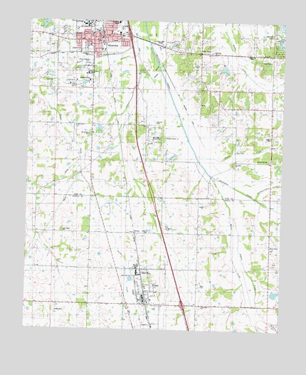
Senatobia, MS USGS Topographic Map
Click on map above to begin viewing in our Map Viewer.

This topographic map contains these locations and features:
Feature Name Type Latitude Longitude GNIS ID View Map
Abes ChapelChurchN34.5398°W89.9679°666134View Map
Abes Chapel CemeteryCemeteryN34.5398°W89.9820°666133View Map
Back Acres Country ClubLocaleN34.5779°W89.9376°683396View Map
Bethel ChurchChurchN34.6115°W89.8848°666976View Map
Bethesda CemeteryCemeteryN34.6114°W89.9700°683399View Map
Bethesda Presbyterian Church (historical)ChurchN34.6120°W89.9709°705989View Map
Brower CemeteryCemeteryN34.6126°W89.8901°667610View Map
Church of ChristChurchN34.6145°W89.9681°683406View Map
Church of ChristChurchN34.6209°W89.9615°683407View Map
Church of ChristChurchN34.6145°W89.9729°683408View Map
Cistern Hill CemeteryCemeteryN34.5096°W89.9140°668491View Map
Cistern Hill ChurchChurchN34.5090°W89.9134°668492View Map
Cistern Hill SchoolSchoolN34.5095°W89.9134°668494View Map
City of SenatobiaCivilN34.6082°W89.9762°2405443View Map
ComoPopulated PlaceN34.5107°W89.9398°668729View Map
Como CemeteryCemeteryN34.5107°W89.9509°668730View Map
Como ChurchChurchN34.5107°W89.9501°668731View Map
Como City Fire DepartmentBuildingN34.5121°W89.9411°2665700View Map
Como City Police DepartmentBuildingN34.5110°W89.9414°2754279View Map
Como Elementary SchoolSchoolN34.5109°W89.9398°707412View Map
Como Post OfficePost OfficeN34.5125°W89.9417°2760198View Map
Como SchoolSchoolN34.5104°W89.9512°668732View Map
East Side Shopping CenterLocaleN34.6198°W89.9590°683417View Map
Elmer Massey Pond DamDamN34.5568°W89.9351°682705View Map
First Baptist ChurchChurchN34.6132°W89.9648°705996View Map
First United Methodist ChurchChurchN34.6154°W89.9640°705998View Map
Gospel Temple Church of God in ChristChurchN34.6170°W89.9529°683426View Map
Gravel SpringsLocaleN34.5676°W89.8973°678168View Map
Gravel Springs CemeteryCemeteryN34.5687°W89.8792°670616View Map
Gravel Springs ChurchChurchN34.5684°W89.8798°670617View Map
Gravel Springs CreekStreamN34.5693°W89.9098°670618View Map
Highland Baptist ChurchChurchN34.6118°W89.9681°705999View Map
Holy Innocents Episcopal ChurchChurchN34.5107°W89.9415°685684View Map
Hunter ChapelChurchN34.5340°W89.8801°685685View Map
Hunters Chapel SchoolSchoolN34.5334°W89.8801°671593View Map
I C Keefer Pond DamDamN34.5751°W89.9584°682718View Map
I C Keefer Pond DamDamN34.5818°W89.9651°682724View Map
Interchange 257CrossingN34.5104°W89.9223°691458View Map
Interchange 265CrossingN34.6193°W89.9512°691459View Map
Lowery CemeteryCemeteryN34.5782°W89.8804°672927View Map
Macedonia ChurchChurchN34.6118°W89.9090°673031View Map
Macedonia SchoolSchoolN34.6118°W89.9090°673040View Map
Magnolia Heights SchoolSchoolN34.6038°W89.9707°683445View Map
Mattic CreekStreamN34.5612°W89.9109°673244View Map
McGheePopulated PlaceN34.5393°W89.9495°692057View Map
Memorial CenterBuildingN34.6007°W89.9704°683448View Map
Miriam Orr Pond DamDamN34.5001°W89.9018°682675View Map
Nelson CreekStreamN34.5462°W89.9001°674553View Map
New TownPopulated PlaceN34.6120°W89.9151°674854View Map
North Oak Regional Medical CenterHospitalN34.6246°W89.9562°706007View Map
North Panola Vocational CenterSchoolN34.5232°W89.9451°685708View Map
Old Caroline CemeteryCemeteryN34.5793°W89.9698°683457View Map
Old Senatobia CanalCanalN34.5859°W89.9212°675253View Map
Oldham CemeteryCemeteryN34.5401°W89.9401°675279View Map
Paul Baddour Pond DamDamN34.6084°W89.9018°682735View Map
Rosewall SchoolSchoolN34.5690°W89.8806°676883View Map
Saint Gregorys Catholic ChurchChurchN34.6193°W89.9740°683466View Map
SenatobiaPopulated PlaceN34.6176°W89.9687°677513View Map
Senatobia Christian ChurchChurchN34.6173°W89.9670°683470View Map
Senatobia Elementary SchoolSchoolN34.6138°W89.9713°706008View Map
Senatobia Fire Department Station 1BuildingN34.6202°W89.9646°2665670View Map
Senatobia Fire Department Station 2BuildingN34.6033°W89.9561°2665690View Map
Senatobia Fire Department Station 3BuildingN34.6200°W89.9955°2665767View Map
Senatobia High SchoolSchoolN34.6234°W89.9658°706009View Map
Senatobia LakesPopulated PlaceN34.6209°W89.8754°683471View Map
Senatobia Middle SchoolSchoolN34.6150°W89.9737°706010View Map
Senatobia Plaza Shopping CenterLocaleN34.6187°W89.9537°683472View Map
Senatobia Police DepartmentBuildingN34.6193°W89.9644°2754207View Map
Senatobia Post OfficePost OfficeN34.6184°W89.9642°2768643View Map
Senatobia Presbyterian ChurchChurchN34.6184°W89.9679°706011View Map
Shady Grove CemeteryCemeteryN34.5823°W89.9762°677549View Map
Shady Grove ChurchChurchN34.5826°W89.9762°677594View Map
Springfield ChurchChurchN34.5682°W89.8968°678178View Map
Tate County CourthouseBuildingN34.6168°W89.9659°683480View Map
Tate County Sheriff's OfficeBuildingN34.6115°W89.9935°2754140View Map
Tolbert-Jones CreekStreamN34.5540°W89.8879°683482View Map
Town of ComoCivilN34.5134°W89.9391°2406302View Map
West DitchCanalN34.6159°W89.9473°683487View Map
Wilborn CreekStreamN34.5034°W89.8806°679671View Map
Woolfolk ChurchChurchN34.6126°W89.9162°679875View Map
WSAO-AM (Senatobia)TowerN34.6157°W89.9359°680166View Map
Zion Hill CemeteryCemeteryN34.5845°W89.9370°680013View Map
Zion Hill ChurchChurchN34.5759°W89.9412°680032View Map
Zion Hill SchoolSchoolN34.5759°W89.9406°680035View Map

Note: Coordinates in the location and feature list above are referenced to NAD83 datum.


Copyright (C) 2008-2024 Ryan Niemi / Sunset Dynamics ... All Rights Reserved