TopoQuest Logo
Do you find TopoQuest useful?
Help keep TopoQuest running and adding new maps/features by donating!
Bitcoin:  19c7KJd3qBynnjoSw5npx9KScwjBe4ifkT
Litecoin:  LXs6TkuXGGXo1vDsWCkWVdjQX94eUKd6ui
Home View Maps Find Maps Find Places Resources & Links


Looxahoma, Mississippi Topographic Map

USGS Map Title: Looxahoma, MS
USGS Map MRC: 34089E7
DRG (GeoTIFF) Download: o34089e7.tif


Neighboring USGS Topographic Map Quads:


  Coldwater, MS  
34089F8
 

  Independence, MS  
34089F7
 

  Wyatte, MS  
34089F6
 

  Senatobia, MS  
34089E8
 

  Looxahoma, MS  
34089E7
 

  Tyro, MS  
34089E6
 

  Sardis, MS  
34089D8
 

  Sardis Dam, MS  
34089D7
 

  Coles Point, MS  
34089D6


Map MRC Location:

N35°
W90°
N35°
W89°
H8 H7 H6 H5 H4 H3 H2 H1
G8 G7 G6 G5 G4 G3 G2 G1
F8 F7 F6 F5 F4 F3 F2 F1
E8 E7 E6 E5 E4 E3 E2 E1
D8 D7 D6 D5 D4 D3 D2 D1
C8 C7 C6 C5 C4 C3 C2 C1
B8 B7 B6 B5 B4 B3 B2 B1
A8 A7 A6 A5 A4 A3 A2 A1
N34°
W90°
N34°
W89°

Looxahoma, MS USGS 1:24K Topographic Map Preview:
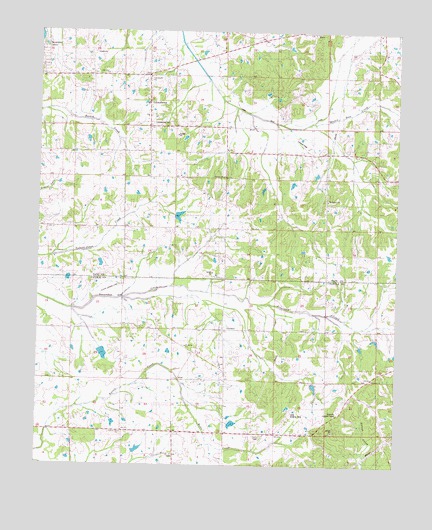
Looxahoma, MS USGS Topographic Map
Click on map above to begin viewing in our Map Viewer.

This topographic map contains these locations and features:
Feature Name Type Latitude Longitude GNIS ID View Map
A G Taylor Estate Pond DamDamN34.5151°W89.8034°682683View Map
BarrPopulated PlaceN34.6245°W89.7801°666538View Map
Bates CreekStreamN34.5190°W89.8234°685630View Map
Beulah CemeteryCemeteryN34.5276°W89.8106°667041View Map
Beulah ChurchChurchN34.5276°W89.8106°667051View Map
Beulah SchoolSchoolN34.5393°W89.8098°667057View Map
Bobo School (historical)SchoolN34.5779°W89.8445°683401View Map
CrossroadPopulated PlaceN34.6120°W89.8370°668972View Map
Ebenezer CemeteryCemeteryN34.5251°W89.7601°669640View Map
Ebenezer ChurchChurchN34.5245°W89.7579°669656View Map
Ebenezer SchoolSchoolN34.5245°W89.7579°669660View Map
Fredonia CemeteryCemeteryN34.5023°W89.8279°670173View Map
Fredonia ChurchChurchN34.5023°W89.8279°670178View Map
Glenville Lookout TowerTowerN34.5154°W89.7704°685678View Map
Hickahala Creek Watershed C-34-9 DamDamN34.5901°W89.7968°682727View Map
Johnsons Chapel SchoolSchoolN34.6198°W89.8376°671951View Map
Lewers Chapel CemeteryCemeteryN34.5848°W89.8098°672415View Map
Lewers Chapel ChurchChurchN34.5848°W89.8098°672416View Map
Lewers Chapel SchoolSchoolN34.5829°W89.8106°672417View Map
Liberty Hill CemeteryCemeteryN34.5084°W89.8456°672464View Map
Liberty Hill ChurchChurchN34.5084°W89.8456°672469View Map
Liberty Hill SchoolSchoolN34.5084°W89.8456°672472View Map
LooxahomaPopulated PlaceN34.5973°W89.8370°672865View Map
Looxahoma CemeteryCemeteryN34.5982°W89.8345°683442View Map
Looxahoma ChurchChurchN34.6118°W89.8368°683443View Map
Looxahoma Church of ChristChurchN34.6007°W89.8376°706004View Map
M P Moore Pond DamDamN34.5584°W89.8551°682707View Map
Martin Dale CreekStreamN34.5993°W89.7804°683446View Map
Mount Moriah ChurchChurchN34.5340°W89.8237°677121View Map
Mount Vernon CemeteryCemeteryN34.5765°W89.7726°674291View Map
Mount Vernon ChurchChurchN34.5762°W89.7745°674310View Map
Mrs Pauline Taylor Pond DamDamN34.5034°W89.8418°682676View Map
New Zion ChurchChurchN34.6126°W89.8518°683456View Map
Pilgrim Rest SchoolSchoolN34.5757°W89.7573°675765View Map
Pleasant Mount (historical)LocaleN34.5095°W89.8093°685723View Map
Saint Maria CemeteryCemeteryN34.5340°W89.8237°677120View Map
Senatobia Creek Watershed Y-7-1 DamDamN34.5734°W89.8301°682716View Map
Senatobia Creek Watershed Y-7-7 DamDamN34.5251°W89.7801°682690View Map
Senatobia Creek Watershed Y-7-8 DamDamN34.5368°W89.8534°682694View Map
Supervisor District 4CivilN34.6092°W89.8338°712093View Map
W S Taylor Junior Pond DamDamN34.5151°W89.8434°682684View Map

Note: Coordinates in the location and feature list above are referenced to NAD83 datum.


Copyright (C) 2008-2025 Ryan Niemi / Sunset Dynamics ... All Rights Reserved