TopoQuest Logo
Do you find TopoQuest useful?
Help keep TopoQuest running and adding new maps/features by donating!
Bitcoin:  19c7KJd3qBynnjoSw5npx9KScwjBe4ifkT
Litecoin:  LXs6TkuXGGXo1vDsWCkWVdjQX94eUKd6ui
Home View Maps Find Maps Find Places Resources & Links


Saxis, Virginia Topographic Map

USGS Map Title: Saxis, VA
USGS Map MRC: 37075H6
DRG (GeoTIFF) Download: o37075h6.tif


Neighboring USGS Topographic Map Quads:


  Pocomoke City, MD  
38075A5
 

  Crisfield, MD  
37075H7
 

  Saxis, VA  
37075H6
 

  Hallwood, VA  
37075H5
 

  Chesconessex, VA  
37075G7
 

  Parksley, VA  
37075G6
 

  Bloxom, VA  
37075G5


Map MRC Location:

N38°
W76°
N38°
W75°
H8 H7 H6 H5 H4 H3 H2 H1
G8 G7 G6 G5 G4 G3 G2 G1
F8 F7 F6 F5 F4 F3 F2 F1
E8 E7 E6 E5 E4 E3 E2 E1
D8 D7 D6 D5 D4 D3 D2 D1
C8 C7 C6 C5 C4 C3 C2 C1
B8 B7 B6 B5 B4 B3 B2 B1
A8 A7 A6 A5 A4 A3 A2 A1
N37°
W76°
N37°
W75°

Saxis, VA USGS 1:24K Topographic Map Preview:
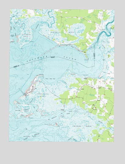
Saxis, VA USGS Topographic Map
Click on map above to begin viewing in our Map Viewer.

This topographic map contains these locations and features:
Feature Name Type Latitude Longitude GNIS ID View Map
Back CoveBayN37.8996°W75.7316°1462642View Map
Back CreekStreamN37.9026°W75.7160°1462651View Map
Baptist Churchyard CemeteryCemeteryN37.9270°W75.7213°2780627View Map
BelindaPopulated PlaceN37.9115°W75.6619°1499113View Map
Big Jones GutStreamN37.9826°W75.7374°583218View Map
Bullbegger CreekStreamN37.9635°W75.6422°1464081View Map
Cattail CreekStreamN37.8768°W75.6816°1464561View Map
Cliftons CreekStreamN37.9621°W75.6774°596782View Map
Dicks PointCapeN37.9035°W75.6774°1465785View Map
Double DitchesCanalN37.9404°W75.6333°1465903View Map
Drum BayBayN37.9048°W75.7449°1465961View Map
Drum PointCapeN37.8993°W75.6877°1465963View Map
East CreekStreamN37.9662°W75.7441°584221View Map
East Creek PointCapeN37.9704°W75.7477°584223View Map
Fair IslandIslandN37.9596°W75.6599°584315View Map
Fair Island CanalCanalN37.9646°W75.6722°584316View Map
Fishing CreekStreamN37.9140°W75.7405°1466610View Map
Flag Pond LandingPopulated PlaceN37.9357°W75.6563°1499421View Map
Freeschool MarshSwampN37.9190°W75.7102°1466881View Map
Green PointCapeN37.9046°W75.6713°1467483View Map
GrotonsPopulated PlaceN37.9262°W75.6435°1499507View Map
Halls ChapelChurchN37.9096°W75.6477°1467673View Map
Hammock LandingLocaleN37.9037°W75.6830°1499518View Map
Holdens CreekStreamN37.9365°W75.6435°1468128View Map
Indian Hammock CoveBayN37.9740°W75.7477°585132View Map
Jacks CreekStreamN37.9329°W75.6905°1468581View Map
Jolleys NeckCapeN37.9512°W75.6322°1468810View Map
Line GutGutN37.9529°W75.6358°1469443View Map
Little Jones GutStreamN37.9840°W75.7408°585476View Map
Makitts CreekStreamN37.9673°W75.6794°596838View Map
Mantrap GutGutN37.9140°W75.7213°1470060View Map
Marsh MarketLocaleN37.9057°W75.6499°1470109View Map
Marumsco CreekStreamN37.9682°W75.7135°585720View Map
Marumsco MarshSwampN37.9787°W75.6852°585721View Map
MessongoPopulated PlaceN37.9146°W75.6394°1499733View Map
Messongo CreekStreamN37.8954°W75.7058°1470378View Map
Michael MarshSwampN37.8896°W75.6613°1470388View Map
Mount Olive ChurchChurchN37.9243°W75.6269°1470978View Map
North End PointCapeN37.9379°W75.7116°1471594View Map
North PointCapeN37.9001°W75.7091°1471632View Map
Peggys GutStreamN37.9918°W75.7480°586463View Map
Persimmon PointCapeN37.9385°W75.6616°1472217View Map
Pig PointCapeN37.9429°W75.6785°1472287View Map
Pilgrim ChurchChurchN37.9268°W75.6508°1472306View Map
Pitts CreekStreamN37.9807°W75.6302°1472449View Map
Pitts NeckCapeN37.9698°W75.6347°1472451View Map
Pocomoke ChurchChurchN37.9257°W75.6430°1472543View Map
Pocomoke RiverStreamN37.9654°W75.6497°586618View Map
PoulsonPopulated PlaceN37.8760°W75.6438°1499905View Map
Richardson MarshSwampN37.9754°W75.7305°586822View Map
Robin Hood BayBayN37.9335°W75.7010°1473326View Map
Rock GutGutN37.8907°W75.6919°1473370View Map
Rumbly PointCapeN37.9698°W75.7249°586961View Map
Saint Johns ChurchChurchN37.9248°W75.6299°1473776View Map
SanfordPopulated PlaceN37.9251°W75.6644°1500028View Map
Sanford Census Designated PlaceCensusN37.9300°W75.6620°2584912View Map
Sanford Post OfficePost OfficeN37.9242°W75.6664°1779676View Map
SaxisPopulated PlaceN37.9240°W75.7219°1500033View Map
Saxis IslandIslandN37.9262°W75.7224°1474084View Map
Saxis Marsh Waterfowl Management Area and RefugeParkN37.9029°W75.6958°1779677View Map
Saxis Post OfficePost OfficeN37.9266°W75.7212°1779678View Map
Saxis Volunteer Fire CompanyBuildingN37.9275°W75.7207°2075657View Map
Scarborough PointCapeN37.8971°W75.7269°1474093View Map
Shad LandingPopulated PlaceN37.9396°W75.6710°1500057View Map
ShelltownPopulated PlaceN37.9798°W75.6399°591269View Map
Shiloh ChurchChurchN37.8807°W75.6433°1474520View Map
Sound ShoreBeachN37.9740°W75.7058°587446View Map
South PointCapeN37.8915°W75.7035°1474879View Map
Starling CreekStreamN37.9193°W75.7322°1475081View Map
The Irish GroveAreaN37.9779°W75.7302°596823View Map
The MudsBarN37.9585°W75.6944°588855View Map
Tims PointCapeN37.9029°W75.6563°1475733View Map
Town of SaxisCivilN37.9260°W75.7231°2391403View Map
Tulls PointCapeN37.9637°W75.7369°587903View Map
Tunnels IslandIslandN37.9046°W75.7297°1475927View Map
Williams PointCapeN37.9537°W75.6566°588253View Map

Note: Coordinates in the location and feature list above are referenced to NAD83 datum.


Copyright (C) 2008-2025 Ryan Niemi / Sunset Dynamics ... All Rights Reserved