TopoQuest Logo
Do you find TopoQuest useful?
Help keep TopoQuest running and adding new maps/features by donating!
Bitcoin:  19c7KJd3qBynnjoSw5npx9KScwjBe4ifkT
Litecoin:  LXs6TkuXGGXo1vDsWCkWVdjQX94eUKd6ui
Home View Maps Find Maps Find Places Resources & Links


Hallwood, Virginia Topographic Map

USGS Map Title: Hallwood, VA
USGS Map MRC: 37075H5
DRG (GeoTIFF) Download: o37075h5.tif


Neighboring USGS Topographic Map Quads:


  Pocomoke City, MD  
38075A5
 

  Girdletree, MD  
38075A4
 

  Saxis, VA  
37075H6
 

  Hallwood, VA  
37075H5
 

  Chincoteague West, VA  
37075H4
 

  Parksley, VA  
37075G6
 

  Bloxom, VA  
37075G5
 

  Wallops Island, VA  
37075G4


Map MRC Location:

N38°
W76°
N38°
W75°
H8 H7 H6 H5 H4 H3 H2 H1
G8 G7 G6 G5 G4 G3 G2 G1
F8 F7 F6 F5 F4 F3 F2 F1
E8 E7 E6 E5 E4 E3 E2 E1
D8 D7 D6 D5 D4 D3 D2 D1
C8 C7 C6 C5 C4 C3 C2 C1
B8 B7 B6 B5 B4 B3 B2 B1
A8 A7 A6 A5 A4 A3 A2 A1
N37°
W76°
N37°
W75°

Hallwood, VA USGS 1:24K Topographic Map Preview:
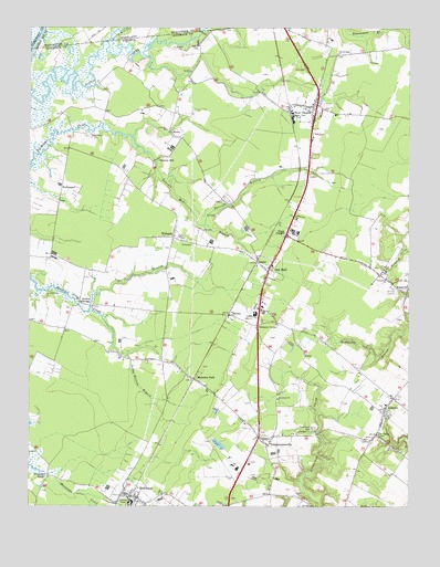
Hallwood, VA USGS Topographic Map
Click on map above to begin viewing in our Map Viewer.

This topographic map contains these locations and features:
Feature Name Type Latitude Longitude GNIS ID View Map
Accomack County Northern Landfill Number 2LocaleN37.9065°W75.5327°2518620View Map
Arcadia High SchoolSchoolN37.9253°W75.5501°2464938View Map
Arcadia Middle SchoolSchoolN37.9246°W75.5541°2465428View Map
Assawoman Post OfficePost OfficeN37.8799°W75.5189°2519589View Map
AtlanticPopulated PlaceN37.9007°W75.5077°1495206View Map
Atlantic Baptist Church CemeteryCemeteryN37.9010°W75.5078°2780433View Map
Atlantic Census Designated PlaceCensusN37.9023°W75.5058°2584800View Map
Atlantic High SchoolSchoolN37.9260°W75.5499°1462611View Map
Atlantic Post OfficePost OfficeN37.9035°W75.5041°1779634View Map
Atlantic United Methodist ChurchChurchN37.9017°W75.5071°2749096View Map
Atlantic United Methodist Church CemeteryCemeteryN37.9019°W75.5070°2780434View Map
Atlantic Volunteer Fire DepartmentBuildingN37.9009°W75.5068°2331663View Map
Badger Technical Center NorthSchoolN37.9250°W75.5501°2465321View Map
Berea United Methodist ChurchChurchN37.9801°W75.5354°2749097View Map
BullbeggerPopulated PlaceN37.9579°W75.6144°1495332View Map
Chincoteague ChurchChurchN37.9932°W75.5233°1464858View Map
District 3CivilN37.9506°W75.5592°1927217View Map
Friendship ChurchChurchN37.9348°W75.5071°1466896View Map
Greenwood CemeteryCemeteryN37.8954°W75.5319°1467516View Map
Greta (historical)Populated PlaceN37.9135°W75.5338°1495622View Map
Gum BranchStreamN37.8762°W75.6049°1467599View Map
HallwoodPopulated PlaceN37.8776°W75.5891°1495643View Map
Hallwood Post OfficePost OfficeN37.8776°W75.5894°1779647View Map
Hancock BranchStreamN37.9487°W75.5669°1467699View Map
High Hopes AirportAirportN37.9339°W75.6086°1498858View Map
HorseyPopulated PlaceN37.9254°W75.5585°1477425View Map
Jenkins BridgeLocaleN37.9282°W75.6080°1468667View Map
Jenkins Bridge Post OfficePost OfficeN37.9218°W75.6130°1779650View Map
Johnson CornerPopulated PlaceN37.9223°W75.5494°1477448View Map
LecatoPopulated PlaceN37.9390°W75.5499°1495831View Map
Little Mill CreekStreamN37.9965°W75.5988°1469593View Map
Little Mill CreekStreamN37.9965°W75.5991°585486View Map
Makemie ParkPopulated PlaceN37.9085°W75.5702°1470024View Map
Makemie Park Census Designated PlaceCensusN37.9106°W75.5845°2584872View Map
Messongo BridgeLocaleN37.8832°W75.6183°1470377View Map
MionaPopulated PlaceN37.9721°W75.5771°1495956View Map
Nasa Mobile Home ParkPopulated PlaceN37.9363°W75.5038°2519923View Map
Nash CornerPopulated PlaceN37.9462°W75.5396°1495992View Map
New ChurchPopulated PlaceN37.9790°W75.5310°1495997View Map
New Church Census Designated PlaceCensusN37.9826°W75.5292°2584891View Map
New Church Post OfficePost OfficeN37.9817°W75.5301°2519635View Map
New Church Volunteer Fire and Rescue Station 1BuildingN37.9783°W75.5334°2075652View Map
North Branch Holdens CreekStreamN37.9271°W75.6046°1474257View Map
Oak HallPopulated PlaceN37.9365°W75.5460°1471747View Map
Oak Hall Census Designated PlaceCensusN37.9308°W75.5469°2584896View Map
Oak Hall Post OfficePost OfficeN37.9271°W75.5482°1779664View Map
Oak Hall RescueBuildingN37.9283°W75.5499°2331833View Map
Pittsville ChurchChurchN37.9737°W75.5794°1472453View Map
Sandy Bottom BranchStreamN37.9148°W75.5924°1474005View Map
Sawyer AirportAirportN37.9910°W75.5925°1498757View Map
Shiloh ChurchChurchN37.8929°W75.5144°1474522View Map
Taylor AirportAirportN37.8821°W75.5060°1498586View Map
TemperancevillePopulated PlaceN37.8929°W75.5471°1496299View Map
Temperanceville Census Designated PlaceCensusN37.8991°W75.5527°2584929View Map
Temperanceville Post OfficePost OfficeN37.8908°W75.5500°2519659View Map
The OaksPopulated PlaceN37.8940°W75.5108°1496307View Map
Town of HallwoodCivilN37.8774°W75.5896°2390224View Map
Tunnels MillPopulated PlaceN37.9665°W75.5808°1496329View Map
Tunnels Mill BranchStreamN37.9715°W75.5910°1475928View Map
WithamsPopulated PlaceN37.9457°W75.5771°1496430View Map
Withams Post OfficePost OfficeN37.9450°W75.5756°1779686View Map

Note: Coordinates in the location and feature list above are referenced to NAD83 datum.


Copyright (C) 2008-2024 Ryan Niemi / Sunset Dynamics ... All Rights Reserved