TopoQuest Logo
Do you find TopoQuest useful?
Help keep TopoQuest running and adding new maps/features by donating!
Bitcoin:  19c7KJd3qBynnjoSw5npx9KScwjBe4ifkT
Litecoin:  LXs6TkuXGGXo1vDsWCkWVdjQX94eUKd6ui
Home View Maps Find Maps Find Places Resources & Links


Sayner, Wisconsin Topographic Map

USGS Map Title: Sayner, WI
USGS Map MRC: 45089H5
DRG (GeoTIFF) Download: o45089h5.tif


Neighboring USGS Topographic Map Quads:


  Boulder Junction, WI  
46089A6
 

  White Sand Lake, WI  
46089A5
 

  Star Lake, WI  
46089A4
 

  Woodruff, WI  
45089H6
 

  Sayner, WI  
45089H5
 

  Saint Germain, WI  
45089H4
 

  Hazelhurst, WI  
45089G6
 

  Lake Tomahawk, WI  
45089G5
 

  Dam Lake, WI  
45089G4


Map MRC Location:

N46°
W90°
N46°
W89°
H8 H7 H6 H5 H4 H3 H2 H1
G8 G7 G6 G5 G4 G3 G2 G1
F8 F7 F6 F5 F4 F3 F2 F1
E8 E7 E6 E5 E4 E3 E2 E1
D8 D7 D6 D5 D4 D3 D2 D1
C8 C7 C6 C5 C4 C3 C2 C1
B8 B7 B6 B5 B4 B3 B2 B1
A8 A7 A6 A5 A4 A3 A2 A1
N45°
W90°
N45°
W89°

Sayner, WI USGS 1:24K Topographic Map Preview:
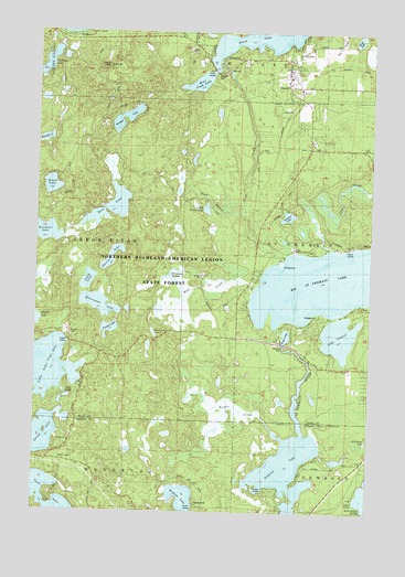
Sayner, WI USGS Topographic Map
Click on map above to begin viewing in our Map Viewer.

This topographic map contains these locations and features:
Feature Name Type Latitude Longitude GNIS ID View Map
Big Saint Germain 1909C361 DamDamN45.9200°W89.5335°1793612View Map
Big Saint Germain LakeLakeN45.9343°W89.5198°1561767View Map
Bittersweet LakeLakeN45.9289°W89.6013°1561834View Map
Bittersweet Lakes State Natural AreaParkN45.9322°W89.6064°2095676View Map
Border CreekStreamN45.8936°W89.5326°1562077View Map
Buffalo LakeLakeN45.8788°W89.5694°1562366View Map
Butterfly LakeLakeN45.9216°W89.5807°1833683View Map
Erickson LakeLakeN45.9474°W89.6225°1564688View Map
Fawn LakeLakeN45.9210°W89.5315°1564885View Map
Hermanson SpringsSpringN45.9361°W89.5751°1833706View Map
Hobo LakeLakeN45.9982°W89.5057°1566499View Map
Kasomo LakeLakeN45.9521°W89.5313°1567351View Map
Lake ContentLakeN45.9210°W89.5113°1563334View Map
Little Arbor Vitae LakeLakeN45.9121°W89.6212°1568167View Map
Little Cloud LakeLakeN45.9538°W89.5618°1568229View Map
Lost CreekStreamN45.9438°W89.5151°1568650View Map
Mud CreekStreamN45.9322°W89.5454°1569884View Map
Muskellunge Lookout TowerTowerN45.9908°W89.6032°1581291View Map
Northern Highland-American Legion State ForestForestN45.9644°W89.5813°1580041View Map
Oberlin LakeLakeN45.9411°W89.5969°1570734View Map
Pickerel LakeLakeN45.8856°W89.5303°1571328View Map
Plum CreekStreamN45.9405°W89.5360°1571688View Map
Plum Lake Ambulance ServiceBuildingN45.9828°W89.5278°2698397View Map
Plum Lake Golf CourseLocaleN45.9963°W89.5129°1873787View Map
Plum Lake Township Volunteer Fire Department Station 1BuildingN45.9867°W89.5338°2696763View Map
Prong LakeLakeN45.9225°W89.5975°1571950View Map
Roach LakeLakeN45.9597°W89.6197°1572393View Map
Ross LakeLakeN45.9541°W89.5975°1572624View Map
Saint Germain RiverStreamN45.8947°W89.5251°1572954View Map
Saint Marys Catholic ChurchChurchN45.9852°W89.5274°1833722View Map
SaynerPopulated PlaceN45.9861°W89.5326°1573765View Map
Sayner Census Designated PlaceCensusN45.9909°W89.5333°2586551View Map
Sayner Post OfficePost OfficeN45.9944°W89.5276°1833725View Map
Shepherd of the Lakes Lutheran ChurchChurchN45.9872°W89.5324°1833727View Map
Smith LakeLakeN45.9351°W89.6057°1574308View Map
West Branch Plum CreekStreamN45.9522°W89.5496°1576476View Map
West Plum LakeLakeN45.9868°W89.5651°1833732View Map
Witches LakeLakeN45.9786°W89.5900°1576920View Map

Note: Coordinates in the location and feature list above are referenced to NAD83 datum.


Copyright (C) 2008-2024 Ryan Niemi / Sunset Dynamics ... All Rights Reserved