TopoQuest Logo
Do you find TopoQuest useful?
Help keep TopoQuest running and adding new maps/features by donating!
Bitcoin:  19c7KJd3qBynnjoSw5npx9KScwjBe4ifkT
Litecoin:  LXs6TkuXGGXo1vDsWCkWVdjQX94eUKd6ui
Home View Maps Find Maps Find Places Resources & Links


Woodruff, Wisconsin Topographic Map

USGS Map Title: Woodruff, WI
USGS Map MRC: 45089H6
DRG (GeoTIFF) Download: o45089h6.tif


Neighboring USGS Topographic Map Quads:


  Manitowish Lake, WI  
46089A7
 

  Boulder Junction, WI  
46089A6
 

  White Sand Lake, WI  
46089A5
 

  Fence Lake, WI  
45089H7
 

  Woodruff, WI  
45089H6
 

  Sayner, WI  
45089H5
 

  Mercer Lake, WI  
45089G7
 

  Hazelhurst, WI  
45089G6
 

  Lake Tomahawk, WI  
45089G5


Map MRC Location:

N46°
W90°
N46°
W89°
H8 H7 H6 H5 H4 H3 H2 H1
G8 G7 G6 G5 G4 G3 G2 G1
F8 F7 F6 F5 F4 F3 F2 F1
E8 E7 E6 E5 E4 E3 E2 E1
D8 D7 D6 D5 D4 D3 D2 D1
C8 C7 C6 C5 C4 C3 C2 C1
B8 B7 B6 B5 B4 B3 B2 B1
A8 A7 A6 A5 A4 A3 A2 A1
N45°
W90°
N45°
W89°

Woodruff, WI USGS 1:24K Topographic Map Preview:
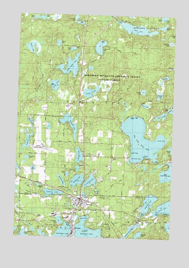
Woodruff, WI USGS Topographic Map
Click on map above to begin viewing in our Map Viewer.

This topographic map contains these locations and features:
Feature Name Type Latitude Longitude GNIS ID View Map
Arbor VitaePopulated PlaceN45.9205°W89.6635°1560919View Map
Arbor Vitae - Woodruff Elementary SchoolSchoolN45.9268°W89.6925°1843826View Map
Arbor Vitae Volunteer Fire and Rescue DepartmentBuildingN45.9207°W89.6620°2696942View Map
Arrowhead LakeLakeN45.9063°W89.6902°1560961View Map
Benedict LakeLakeN45.9554°W89.6360°1561558View Map
Big Arbor Vitae LakeLakeN45.9303°W89.6497°1561675View Map
Black Tern Bog State Natural AreaParkN45.9675°W89.6978°2095683View Map
Brandy LakeLakeN45.9068°W89.7008°1577307View Map
Brandy Lake ParkParkN45.9008°W89.7018°1833682View Map
Bug LakeLakeN45.9496°W89.6477°1562377View Map
Bullhead LakeLakeN45.8843°W89.7141°1562402View Map
Camp LakeLakeN45.9979°W89.7333°1562627View Map
Carrol LakeLakeN45.8938°W89.6257°1562742View Map
Clumbs IslandIslandN45.8783°W89.6957°1563213View Map
Devine LakeLakeN45.9811°W89.7399°1563950View Map
Doctor Kate Pelham Newcomb MuseumBuildingN45.8961°W89.6996°1843838View Map
Dry LakeLakeN45.9426°W89.6355°1564124View Map
Emerald LakeLakeN45.9937°W89.6350°1564613View Map
Evergreen CemeteryCemeteryN45.8916°W89.6990°1873781View Map
Fallison LakeLakeN45.9919°W89.6257°1564846View Map
Faulkner LakeLakeN45.9192°W89.7417°1564879View Map
Faulkner School (historical)SchoolN45.9158°W89.7265°1873785View Map
Firefly LakeLakeN45.9988°W89.6388°1564956View Map
Forest Garden CemeteryCemeteryN45.8980°W89.6751°1843850View Map
Gravelly BayBayN45.9211°W89.6568°1565784View Map
Hall School (historical)SchoolN45.9463°W89.7268°1873786View Map
Halls LakeLakeN45.9392°W89.7389°1566000View Map
Harriet LakeLakeN45.9140°W89.7497°1566083View Map
Hemlock LakeLakeN45.8766°W89.6511°1566291View Map
Hillis LakeLakeN45.9103°W89.7088°1566442View Map
Howard Young Medical CenterHospitalN45.8939°W89.7021°1843856View Map
Huber BayBayN45.8861°W89.6940°1843857View Map
Hungry LakeLakeN45.9068°W89.7132°1566805View Map
Hurrah LakeLakeN45.9574°W89.6496°1566824View Map
Ila CreekStreamN45.9008°W89.7418°1566856View Map
Ila LakeLakeN45.9132°W89.7366°1566857View Map
Johnson CreekStreamN45.8997°W89.7493°1567217View Map
Johnson LakeLakeN45.8997°W89.7206°1567236View Map
Klondike LakeLakeN45.9708°W89.6296°1567555View Map
Lakeland Airport/Noble F. Lee Memorial FieldAirportN45.9267°W89.7294°1581038View Map
Lakeland Union High SchoolSchoolN45.8864°W89.7074°1843867View Map
Link CreekStreamN45.9175°W89.6321°1568150View Map
Little Bass LakeLakeN45.9136°W89.7006°1567669View Map
Little Muskie LakeLakeN45.9209°W89.6996°1568331View Map
Little Rock LakeLakeN45.9957°W89.7025°1568389View Map
Little Spider LakeLakeN45.9711°W89.7084°1568422View Map
Lucia BayBayN45.9297°W89.6371°1568782View Map
Madeline LakeLakeN45.8947°W89.6432°1568880View Map
Mann LakeLakeN45.9926°W89.6562°1568949View Map
Mielke LakeLakeN45.9250°W89.6256°1569450View Map
Minocqua 1909C361 DamDamN45.8766°W89.7285°1793009View Map
Minocqua Census Designated PlaceCensusN45.8788°W89.7032°2586533View Map
Minocqua Reservoir 89ReservoirN45.8766°W89.7285°1793010View Map
Oneida County AmbulanceBuildingN45.8938°W89.7023°2698343View Map
Pauto LakeLakeN45.9809°W89.7068°1571097View Map
Punch LakeLakeN45.9838°W89.7185°1571975View Map
Safford LakeLakeN45.9039°W89.7320°1833719View Map
Scaffold LakeLakeN45.9656°W89.6313°1573766View Map
Schoolhouse BayBayN45.8819°W89.7071°1843906View Map
Snake LakeLakeN45.8989°W89.6941°1843908View Map
Sumach LakeLakeN45.9279°W89.7415°1575050View Map
Towanda LakeLakeN45.9385°W89.7077°1575520View Map
Town of Arbor VitaeCivilN45.9607°W89.6787°1582704View Map
Trapp Brothers PitMineN45.9481°W89.7058°2635554View Map
Trilby LakeLakeN45.9568°W89.6917°1575606View Map
Trinity Evangelical Lutheran ChurchChurchN45.8905°W89.6849°1843920View Map
Trinity Lutheran SchoolSchoolN45.8900°W89.6851°1843921View Map
Vandercook LakeLakeN45.9821°W89.6852°1576047View Map
Verna LakeLakeN45.9604°W89.7207°1833729View Map
Wildwood LakeLakeN45.9844°W89.6329°1576749View Map
WoodruffPopulated PlaceN45.8963°W89.6990°1577018View Map
Woodruff Baptist ChurchChurchN45.8938°W89.6954°1843927View Map
Woodruff Census Designated PlaceCensusN45.8946°W89.6911°2586577View Map
Woodruff Community BuildingBuildingN45.8983°W89.6957°1843928View Map
Woodruff Fish HatcheryLocaleN45.8844°W89.6515°1843929View Map
Woodruff Police DepartmentBuildingN45.8951°W89.6883°2759750View Map
Woodruff Volunteer Fire DepartmentBuildingN45.8957°W89.6868°2696961View Map

Note: Coordinates in the location and feature list above are referenced to NAD83 datum.


Copyright (C) 2008-2025 Ryan Niemi / Sunset Dynamics ... All Rights Reserved