TopoQuest Logo
Do you find TopoQuest useful?
Help keep TopoQuest running and adding new maps/features by donating!
Bitcoin:  19c7KJd3qBynnjoSw5npx9KScwjBe4ifkT
Litecoin:  LXs6TkuXGGXo1vDsWCkWVdjQX94eUKd6ui
Home View Maps Find Maps Find Places Resources & Links


Scalf, Kentucky Topographic Map

USGS Map Title: Scalf, KY
USGS Map MRC: 36083H6
DRG (GeoTIFF) Download: o36083h6.tif


Neighboring USGS Topographic Map Quads:


  Hima, KY  
37083A7
 

  Ogle, KY  
37083A6
 

  Creekville, KY  
37083A5
 

  Fount, KY  
36083H7
 

  Scalf, KY  
36083H6
 

  Beverly, KY  
36083H5
 

  Artemus, KY  
36083G7
 

  Pineville, KY  
36083G6
 

  Balkan, KY  
36083G5


Map MRC Location:

N37°
W84°
N37°
W83°
H8 H7 H6 H5 H4 H3 H2 H1
G8 G7 G6 G5 G4 G3 G2 G1
F8 F7 F6 F5 F4 F3 F2 F1
E8 E7 E6 E5 E4 E3 E2 E1
D8 D7 D6 D5 D4 D3 D2 D1
C8 C7 C6 C5 C4 C3 C2 C1
B8 B7 B6 B5 B4 B3 B2 B1
A8 A7 A6 A5 A4 A3 A2 A1
N36°
W84°
N36°
W83°

Scalf, KY USGS 1:24K Topographic Map Preview:
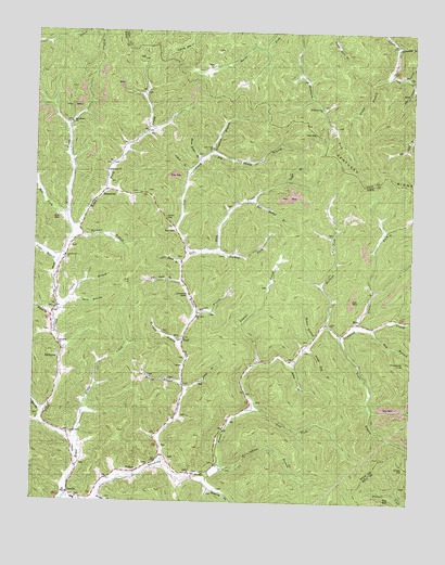
Scalf, KY USGS Topographic Map
Click on map above to begin viewing in our Map Viewer.

This topographic map contains these locations and features:
Feature Name Type Latitude Longitude GNIS ID View Map
Abe HollowValleyN36.9865°W83.6256°510197View Map
Acorn ForkStreamN36.9223°W83.6430°510210View Map
Bailey BranchStreamN36.9123°W83.6641°510341View Map
Bargo SchoolSchoolN36.9551°W83.6813°510392View Map
BarnyardLocaleN36.9134°W83.7413°510417View Map
Barnyard Post Office (historical)Post OfficeN36.9131°W83.7408°2543222View Map
Bell ForkStreamN36.9504°W83.7388°510537View Map
Big Beech BranchStreamN36.9340°W83.7010°510596View Map
Big Shady BranchStreamN36.9681°W83.6921°510693View Map
Bingham BranchStreamN36.9681°W83.6921°510730View Map
Bob Bargo BranchStreamN36.9556°W83.6774°510821View Map
Brices CreekStreamN36.8893°W83.7352°510908View Map
Broughton SchoolSchoolN36.9648°W83.7244°510942View Map
Browns BranchStreamN36.9062°W83.7002°510957View Map
Buckeye ForkStreamN36.9218°W83.6532°511018View Map
Burnt House BranchStreamN36.9659°W83.6955°511085View Map
Camel BranchStreamN36.9623°W83.6991°511140View Map
Campbells Store (historical)LocaleN36.8757°W83.7336°2543238View Map
Caney GapGapN36.9506°W83.7069°511204View Map
Carnes SchoolSchoolN36.8823°W83.6974°511219View Map
Caudill Post Office (historical)Post OfficeN36.9797°W83.7125°2543241View Map
Cave Rock Post Office (historical)Post OfficeN36.9176°W83.6597°2554741View Map
Clark BranchStreamN36.9254°W83.7431°511868View Map
Clay GapGapN36.9729°W83.6569°511381View Map
Cole Branch ChurchChurchN36.9398°W83.7399°507356View Map
Coles BranchStreamN36.9381°W83.7419°511467View Map
DewittPopulated PlaceN36.8770°W83.7377°511802View Map
Dewitt DivisionCivilN36.9194°W83.6894°1936975View Map
Dewitt Elementary SchoolSchoolN36.8756°W83.7358°2554729View Map
Dora BranchStreamN36.9284°W83.7380°512540View Map
Fellowship ChurchChurchN36.9628°W83.7260°516562View Map
Greasy GapGapN36.8848°W83.6257°512423View Map
Grubb BranchStreamN36.9895°W83.6324°512474View Map
Hale ForkStreamN36.8987°W83.7469°512505View Map
HammondPopulated PlaceN36.9570°W83.7274°512539View Map
Henry BranchStreamN36.9181°W83.6566°512651View Map
Hinkle BranchStreamN36.9234°W83.7433°512715View Map
Hog BranchStreamN36.9218°W83.6369°512722View Map
Holiness ChurchChurchN36.9165°W83.7410°516563View Map
Hubbard BranchStreamN36.9176°W83.7016°512823View Map
Hubbards Fork ChurchChurchN36.9798°W83.6552°512825View Map
Hubbards Mill (historical)LocaleN36.9176°W83.7019°2543291View Map
Huckleberry KnobSummitN36.9123°W83.6269°512828View Map
Hurricane BranchStreamN36.9968°W83.6307°512859View Map
Jackson SchoolSchoolN36.9398°W83.7396°512972View Map
Jeff CreekStreamN36.9406°W83.6988°512984View Map
Jeff Creek ChurchChurchN36.9692°W83.6914°2091958View Map
Jeff Creek SchoolSchoolN36.9654°W83.6949°512985View Map
Johns BranchStreamN36.9045°W83.6994°513037View Map
Kinningham BranchStreamN36.8843°W83.6883°513157View Map
Laurel CreekStreamN36.9120°W83.6746°513238View Map
Little Beech BranchStreamN36.9376°W83.7016°513448View Map
Lost ForkStreamN36.8995°W83.6769°513640View Map
Macroe BranchStreamN36.9240°W83.6974°513754View Map
Macroe SchoolSchoolN36.9218°W83.6985°513755View Map
Meadow BranchStreamN36.8756°W83.7280°513889View Map
Messer SchoolSchoolN36.9123°W83.6760°513914View Map
Messer Store (historical)LocaleN36.9228°W83.6526°2543311View Map
Middle Fork Stinking CreekStreamN36.8856°W83.7071°513941View Map
Mill Mission ChurchChurchN36.9812°W83.7383°516566View Map
MillsLocaleN36.9229°W83.6427°514013View Map
Mills CreekStreamN36.9462°W83.7374°514015View Map
Mills Creek SchoolSchoolN36.9754°W83.7385°514016View Map
Mills Post Office (historical)Post OfficeN36.9233°W83.6433°2554744View Map
Mills-Messer CemeteryCemeteryN36.9181°W83.6586°2543312View Map
Mission SchoolSchoolN36.8856°W83.6877°516568View Map
Parkers BranchStreamN36.9448°W83.7371°514436View Map
Road Fork CreekStreamN36.8768°W83.7383°514978View Map
Roaring ForkStreamN36.8815°W83.6916°514992View Map
Salem Baptist ChurchChurchN36.9229°W83.6519°516567View Map
Salt GumLocaleN36.9479°W83.7038°515187View Map
Salt Gum ChurchChurchN36.9243°W83.6960°515188View Map
Salt Gum CreekStreamN36.9404°W83.6988°515189View Map
Salt Gum Post Office (historical)Post OfficeN36.9474°W83.7046°2543341View Map
ScalfPopulated PlaceN36.9184°W83.7002°515279View Map
Scalf Post OfficePost OfficeN36.9181°W83.7004°2543342View Map
Shady SchoolSchoolN36.9193°W83.6480°515335View Map
Shingle Roof BranchStreamN36.9159°W83.6602°515358View Map
Smallwood Post Office (historical)Post OfficeN36.9906°W83.6335°2543157View Map
Stinking Creek Fire DepartmentBuildingN36.8875°W83.7069°2636823View Map
The Forks of StinkingLocaleN36.8765°W83.7389°2554730View Map
The Three KnobsSummitN36.8846°W83.6365°2543377View Map
Trace BranchStreamN36.9187°W83.6485°516007View Map
Tuggle ForkStreamN36.9606°W83.6666°516034View Map
Turkey ForkStreamN36.9418°W83.6888°516050View Map
Upper Mill Creek SchoolSchoolN36.9915°W83.6977°516143View Map
WalkerPopulated PlaceN36.8831°W83.7149°516204View Map
Walker ChurchChurchN36.8826°W83.6935°516565View Map
Walker Post OfficePost OfficeN36.8833°W83.7156°2543370View Map
Waterfall BranchStreamN36.9881°W83.6274°516243View Map
Young Grove ChurchChurchN36.8934°W83.7369°516515View Map

Note: Coordinates in the location and feature list above are referenced to NAD83 datum.


Copyright (C) 2008-2025 Ryan Niemi / Sunset Dynamics ... All Rights Reserved