TopoQuest Logo
Do you find TopoQuest useful?
Help keep TopoQuest running and adding new maps/features by donating!
Bitcoin:  19c7KJd3qBynnjoSw5npx9KScwjBe4ifkT
Litecoin:  LXs6TkuXGGXo1vDsWCkWVdjQX94eUKd6ui
Home View Maps Find Maps Find Places Resources & Links


Schoolcraft NW, Michigan Topographic Map

USGS Map Title: Schoolcraft NW, MI
USGS Map MRC: 42085B6
DRG (GeoTIFF) Download: o42085b6.tif


Neighboring USGS Topographic Map Quads:


  Gobles East, MI  
42085C7
 

  Kalamazoo SW, MI  
42085C6
 

  Kalamazoo, MI  
42085C5
 

  Lawton, MI  
42085B7
 

  Schoolcraft NW, MI  
42085B6
 

  Portage, MI  
42085B5
 

  Marcellus, MI  
42085A7
 

  Schoolcraft, MI  
42085A6
 

  Vicksburg, MI  
42085A5


Map MRC Location:

N43°
W86°
N43°
W85°
H8 H7 H6 H5 H4 H3 H2 H1
G8 G7 G6 G5 G4 G3 G2 G1
F8 F7 F6 F5 F4 F3 F2 F1
E8 E7 E6 E5 E4 E3 E2 E1
D8 D7 D6 D5 D4 D3 D2 D1
C8 C7 C6 C5 C4 C3 C2 C1
B8 B7 B6 B5 B4 B3 B2 B1
A8 A7 A6 A5 A4 A3 A2 A1
N42°
W86°
N42°
W85°

Schoolcraft NW, MI USGS 1:24K Topographic Map Preview:
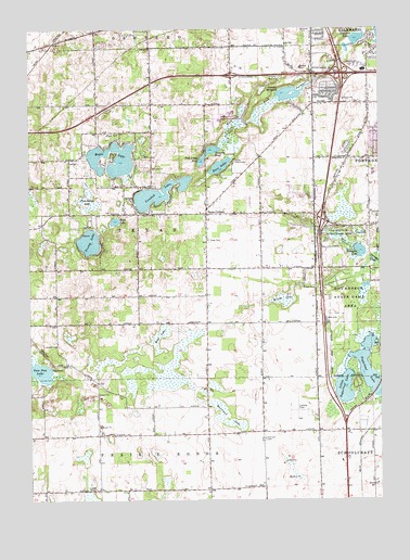
Schoolcraft NW, MI USGS Topographic Map
Click on map above to begin viewing in our Map Viewer.

This topographic map contains these locations and features:
Feature Name Type Latitude Longitude GNIS ID View Map
Angling Road Elementary SchoolSchoolN42.2389°W85.6306°2612565View Map
Atwater MillpondLakeN42.2328°W85.6572°620312View Map
Bass LakeLakeN42.2136°W85.6817°620680View Map
Borgess at Woodbridge HillsHospitalN42.2042°W85.6431°2627804View Map
Calvary ChurchChurchN42.2045°W85.7133°622483View Map
Camp Rota-KiwanLocaleN42.2150°W85.6769°622624View Map
Charter Township of TexasCivilN42.2013°W85.7067°1627158View Map
Crooked LakeLakeN42.2065°W85.7038°624092View Map
Duck LakeLakeN42.1991°W85.7193°624924View Map
Eagle LakeLakeN42.2131°W85.7208°625081View Map
Fish Camp PondLakeN42.2152°W85.6882°626025View Map
Gourdneck State Game AreaParkN42.1795°W85.6347°627027View Map
Hampton LakeLakeN42.1912°W85.6322°627704View Map
Harrison CemeteryCemeteryN42.1414°W85.6661°627851View Map
Harrison LakeSwampN42.1467°W85.6794°627858View Map
Hope CemeteryCemeteryN42.1939°W85.6858°628555View Map
Interchange 31CrossingN42.1994°W85.6456°2611887View Map
Interchange 34CrossingN42.2381°W85.6375°2611889View Map
Interchange 72CrossingN42.2375°W85.6772°1623441View Map
Interchange 74CrossingN42.2378°W85.6375°1623442View Map
Kalamazoo Region Historical MarkerParkN42.2372°W85.6625°2611912View Map
Kalamazoo Valley Community CollegeSchoolN42.2264°W85.6803°629446View Map
Life Point ChurchChurchN42.2361°W85.6408°2627798View Map
Lighthouse Community ChurchChurchN42.2499°W85.6561°2612537View Map
Limekiln LakeLakeN42.2466°W85.6334°630434View Map
Little Sugarloaf LakeLakeN42.1549°W85.6379°630782View Map
Moors Golf ClubLocaleN42.2017°W85.6344°2612566View Map
Moorsbridge Elementary SchoolSchoolN42.2103°W85.6268°2612567View Map
Mud LakeLakeN42.1686°W85.7035°633056View Map
Oak Brook Estates Mobile Home ParkPopulated PlaceN42.1917°W85.6667°2627708View Map
Paw Paw LakeLakeN42.1607°W85.7494°634492View Map
Perry AirportAirportN42.1488°W85.6499°1624152View Map
Pine IslandSwampN42.2048°W85.7297°634948View Map
Portage Church of ChristChurchN42.2264°W85.6469°2627799View Map
Portage West Middle SchoolSchoolN42.2119°W85.6272°2612568View Map
Pretty LakeLakeN42.1937°W85.7288°635443View Map
Pretty Lake CemeteryCemeteryN42.1958°W85.7308°2627927View Map
Saddlebrook Farms Manufactured Home CommunityPopulated PlaceN42.2439°W85.7250°2627710View Map
Schoolcraft Assembly of God ChurchChurchN42.1283°W85.6399°2627856View Map
Scouters PondLakeN42.2180°W85.6844°637487View Map
Sugarloaf LakeLakeN42.1610°W85.6299°639028View Map
Sugarloaf Mobile Home ParkPopulated PlaceN42.1508°W85.6292°2627857View Map
Texas Charter Township Fire and RescueBuildingN42.2016°W85.6892°2635937View Map
Texas CornersPopulated PlaceN42.2012°W85.6867°1614693View Map
Texas Post Office (historical)Post OfficeN42.2011°W85.6867°2612222View Map
Weeds LakeSwampN42.1784°W85.6594°1615965View Map
Westfield ParkParkN42.2308°W85.6458°2627813View Map
Whitcomb FieldAirportN42.1805°W85.6693°1624153View Map
Woodland Estates Mobile Home ParkPopulated PlaceN42.2458°W85.7250°2627711View Map
Wyngate Farms Manufactured Home CommunityPopulated PlaceN42.2361°W85.6744°2627709View Map

Note: Coordinates in the location and feature list above are referenced to NAD83 datum.


Copyright (C) 2008-2024 Ryan Niemi / Sunset Dynamics ... All Rights Reserved