TopoQuest Logo
Do you find TopoQuest useful?
Help keep TopoQuest running and adding new maps/features by donating!
Bitcoin:  19c7KJd3qBynnjoSw5npx9KScwjBe4ifkT
Litecoin:  LXs6TkuXGGXo1vDsWCkWVdjQX94eUKd6ui
Home View Maps Find Maps Find Places Resources & Links


Scotland, Arkansas Topographic Map

USGS Map Title: Scotland, AR
USGS Map MRC: 35092E5
DRG (GeoTIFF) Download: o35092e5.tif


Neighboring USGS Topographic Map Quads:


  Alread, AR  
35092F6
 

  Botkinburg, AR  
35092F5
 

  Old Lexington, AR  
35092F4
 

  Rex, AR  
35092E6
 

  Scotland, AR  
35092E5
 

  Clinton, AR  
35092E4
 

  Cleveland, AR  
35092D6
 

  Formosa, AR  
35092D5
 

  Bee Branch, AR  
35092D4


Map MRC Location:

N36°
W93°
N36°
W92°
H8 H7 H6 H5 H4 H3 H2 H1
G8 G7 G6 G5 G4 G3 G2 G1
F8 F7 F6 F5 F4 F3 F2 F1
E8 E7 E6 E5 E4 E3 E2 E1
D8 D7 D6 D5 D4 D3 D2 D1
C8 C7 C6 C5 C4 C3 C2 C1
B8 B7 B6 B5 B4 B3 B2 B1
A8 A7 A6 A5 A4 A3 A2 A1
N35°
W93°
N35°
W92°

Scotland, AR USGS 1:24K Topographic Map Preview:
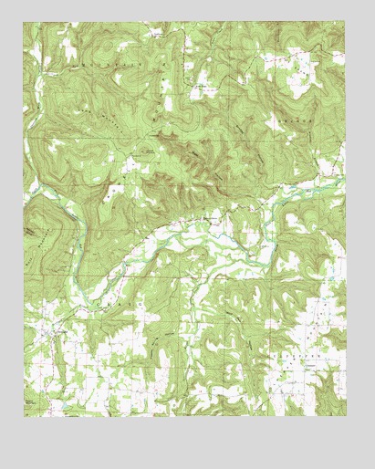
Scotland, AR USGS Topographic Map
Click on map above to begin viewing in our Map Viewer.

This topographic map contains these locations and features:
Feature Name Type Latitude Longitude GNIS ID View Map
Bradley BranchStreamN35.5717°W92.5124°46889View Map
Bradley CemeteryCemeteryN35.5762°W92.5052°46893View Map
Brickey HollowValleyN35.5720°W92.5177°46935View Map
Butter CreekStreamN35.5490°W92.5377°47241View Map
Butter Creek (historical)Populated PlaceN35.5420°W92.5571°68648View Map
Buzzard Roost (historical)Populated PlaceN35.5762°W92.5115°68649View Map
Copper Spring HollowValleyN35.5251°W92.5618°48028View Map
CrabtreePopulated PlaceN35.6204°W92.5752°76700View Map
Crowell CemeteryCemeteryN35.5890°W92.5771°48232View Map
Crowell ChurchChurchN35.5826°W92.5829°48233View Map
Crowell MountainSummitN35.6137°W92.5715°57614View Map
Crowell PinnacleSummitN35.5840°W92.5782°48234View Map
CulpepperPopulated PlaceN35.5162°W92.5165°76729View Map
Culpepper Fire DepartmentBuildingN35.5219°W92.5158°2116332View Map
Culpepper MountainSummitN35.5167°W92.5179°48253View Map
Dry ForkStreamN35.6084°W92.6185°48659View Map
Evans CemeteryCemeteryN35.6120°W92.5138°48932View Map
Foster CemeteryCemeteryN35.5342°W92.5927°49190View Map
Gardner CemeteryCemeteryN35.5690°W92.6146°49338View Map
Gladys (historical)Populated PlaceN35.5676°W92.6127°68667View Map
Joneed CreekStreamN35.5256°W92.6174°68674View Map
Koch RidgeLocaleN35.6045°W92.5596°77415View Map
Long MountainSummitN35.5870°W92.5852°58083View Map
Mount EvansSummitN35.6106°W92.5215°57732View Map
Opossum Walk CreekStreamN35.5734°W92.6182°53062View Map
Pine Mountain (historical)Populated PlaceN35.5231°W92.5910°68687View Map
Pleasant Grove Methodist ChurchChurchN35.5001°W92.6102°78039View Map
ScotlandPopulated PlaceN35.5276°W92.6118°58594View Map
Scotland BranchStreamN35.5381°W92.5952°73496View Map
Scotland Elementary SchoolSchoolN35.5230°W92.6134°68695View Map
Scotland High SchoolSchoolN35.5236°W92.6134°68696View Map
Scotland Post OfficePost OfficeN35.5280°W92.6121°84434View Map
Township of CraigCivilN35.5325°W92.5951°69765View Map
Van Buren CountyCivilN35.5807°W92.5157°69904View Map
Walnut GrovePopulated PlaceN35.5623°W92.5557°78680View Map
Walnut Grove Volunteer Fire DepartmentBuildingN35.5668°W92.5401°2117267View Map
West HollowValleyN35.5651°W92.5290°56189View Map
Wolf Pen HollowValleyN35.5342°W92.5563°56498View Map

Note: Coordinates in the location and feature list above are referenced to NAD83 datum.


Copyright (C) 2008-2024 Ryan Niemi / Sunset Dynamics ... All Rights Reserved