TopoQuest Logo
Do you find TopoQuest useful?
Help keep TopoQuest running and adding new maps/features by donating!
Bitcoin:  19c7KJd3qBynnjoSw5npx9KScwjBe4ifkT
Litecoin:  LXs6TkuXGGXo1vDsWCkWVdjQX94eUKd6ui
Home View Maps Find Maps Find Places Resources & Links


Old Lexington, Arkansas Topographic Map

USGS Map Title: Old Lexington, AR
USGS Map MRC: 35092F4
DRG (GeoTIFF) Download: o35092f4.tif


Neighboring USGS Topographic Map Quads:


  Leslie, AR  
35092G5
 

  Oxley, AR  
35092G4
 

  Fox, AR  
35092G3
 

  Botkinburg, AR  
35092F5
 

  Old Lexington, AR  
35092F4
 

  Shirley, AR  
35092F3
 

  Scotland, AR  
35092E5
 

  Clinton, AR  
35092E4
 

  Fairfield Bay, AR  
35092E3


Map MRC Location:

N36°
W93°
N36°
W92°
H8 H7 H6 H5 H4 H3 H2 H1
G8 G7 G6 G5 G4 G3 G2 G1
F8 F7 F6 F5 F4 F3 F2 F1
E8 E7 E6 E5 E4 E3 E2 E1
D8 D7 D6 D5 D4 D3 D2 D1
C8 C7 C6 C5 C4 C3 C2 C1
B8 B7 B6 B5 B4 B3 B2 B1
A8 A7 A6 A5 A4 A3 A2 A1
N35°
W93°
N35°
W92°

Old Lexington, AR USGS 1:24K Topographic Map Preview:
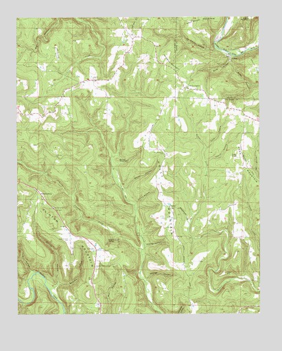
Old Lexington, AR USGS Topographic Map
Click on map above to begin viewing in our Map Viewer.

This topographic map contains these locations and features:
Feature Name Type Latitude Longitude GNIS ID View Map
Ab Smith HollowValleyN35.7365°W92.3968°45771View Map
ArlbergPopulated PlaceN35.7337°W92.3893°56910View Map
Bane HollowValleyN35.7337°W92.3888°46073View Map
Beavers HollowValleyN35.6367°W92.4818°46281View Map
Big BranchStreamN35.6823°W92.3752°46517View Map
Botkinburg Volunteer Fire DepartmentBuildingN35.6607°W92.4734°2116184View Map
Cedar HillSummitN35.6417°W92.3943°47615View Map
Charles HollowValleyN35.6540°W92.4346°47707View Map
Church HollowValleyN35.6892°W92.4021°47782View Map
Clark HollowValleyN35.6948°W92.4024°47805View Map
Clinton MountainSummitN35.6665°W92.4846°57557View Map
Coley KnobSummitN35.6923°W92.3865°57571View Map
Collins HollowValleyN35.6381°W92.4790°47934View Map
Corinth ChurchChurchN35.6704°W92.4213°48053View Map
Elliott HollowValleyN35.6709°W92.4390°48858View Map
Garretts Roost Airport (historical)AirportN35.7351°W92.4793°83664View Map
George HollowValleyN35.6395°W92.4335°49372View Map
Highway 110 Volunteer Fire DepartmentBuildingN35.7437°W92.4423°2116567View Map
Holley Mountain AirparkAirportN35.6487°W92.4087°2650738View Map
Holly MountainSummitN35.6890°W92.4238°57933View Map
Holly Mountain CemeteryCemeteryN35.6926°W92.4240°50232View Map
Lexington MountainSummitN35.7287°W92.4207°58065View Map
Lick HollowValleyN35.6431°W92.4899°51152View Map
Little Johnnies CreekStreamN35.6520°W92.4354°51291View Map
Miller HollowValleyN35.7326°W92.3890°52064View Map
Mountain View CemeteryCemeteryN35.6565°W92.4729°52500View Map
Mountain View ChurchChurchN35.6451°W92.4596°52505View Map
Natural Bridge of ArkansasArchN35.6561°W92.4497°2571574View Map
Old BotkinburgPopulated PlaceN35.6762°W92.4882°58300View Map
Old LexingtonPopulated PlaceN35.7198°W92.4110°77906View Map
PlantPopulated PlaceN35.7237°W92.4604°68688View Map
Plant Baptist ChurchChurchN35.7242°W92.4602°78028View Map
Round MountainSummitN35.6901°W92.4482°58539View Map
Schoolhouse HollowValleyN35.6645°W92.4115°54626View Map
Shady Grove ChurchChurchN35.7006°W92.3832°54717View Map
Township of Holley (historical)CivilN35.6709°W92.4154°69770View Map
Township of Holly MountainCivilN35.6699°W92.3982°1986410View Map
Township of Linn CreekCivilN35.7235°W92.4586°69773View Map
Township of Red RiverCivilN35.7427°W92.3791°69731View Map
White HollowValleyN35.6779°W92.4440°56257View Map

Note: Coordinates in the location and feature list above are referenced to NAD83 datum.


Copyright (C) 2008-2024 Ryan Niemi / Sunset Dynamics ... All Rights Reserved