TopoQuest Logo
Do you find TopoQuest useful?
Help keep TopoQuest running and adding new maps/features by donating!
Bitcoin:  19c7KJd3qBynnjoSw5npx9KScwjBe4ifkT
Litecoin:  LXs6TkuXGGXo1vDsWCkWVdjQX94eUKd6ui
Home View Maps Find Maps Find Places Resources & Links


Sebec Lake West, Maine Topographic Map

USGS Map Title: Sebec Lake West, ME
USGS Map MRC: 45069C3
DRG (GeoTIFF) Download: o45069c3.tif


Neighboring USGS Topographic Map Quads:


  Barren Mountain West, ME  
45069D4
 

  Barren Mountain East, ME  
45069D3
 

  Silver Lake, ME  
45069D2
 

  Monson East, ME  
45069C4
 

  Sebec Lake West, ME  
45069C3
 

  Sebec Lake East, ME  
45069C2
 

  Guilford, ME  
45069B4
 

  Sangerville, ME  
45069B3
 

  Dover-Foxcroft, ME  
45069B2


Map MRC Location:

N46°
W70°
N46°
W69°
H8 H7 H6 H5 H4 H3 H2 H1
G8 G7 G6 G5 G4 G3 G2 G1
F8 F7 F6 F5 F4 F3 F2 F1
E8 E7 E6 E5 E4 E3 E2 E1
D8 D7 D6 D5 D4 D3 D2 D1
C8 C7 C6 C5 C4 C3 C2 C1
B8 B7 B6 B5 B4 B3 B2 B1
A8 A7 A6 A5 A4 A3 A2 A1
N45°
W70°
N45°
W69°

Sebec Lake West, ME USGS 1:24K Topographic Map Preview:
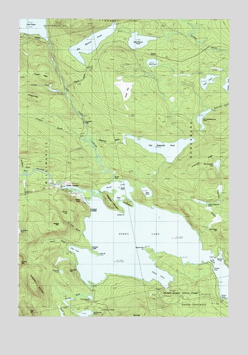
Sebec Lake West, ME USGS Topographic Map
Click on map above to begin viewing in our Map Viewer.

This topographic map contains these locations and features:
Feature Name Type Latitude Longitude GNIS ID View Map
Bear PondLakeN45.3025°W69.2985°561861View Map
Ben Chase HillSummitN45.2864°W69.2547°562037View Map
Bennett BrookStreamN45.2642°W69.3337°562056View Map
BensonPopulated PlaceN45.3595°W69.2956°579132View Map
Benson BrookStreamN45.3453°W69.3484°562065View Map
Big Bennett PondLakeN45.2509°W69.3351°562129View Map
Big Bennett Pond OutletReservoirN45.2529°W69.3419°1774666View Map
Big Bennett Pond Outlet DamDamN45.2529°W69.3419°1774665View Map
Big Benson PondLakeN45.3648°W69.3319°562130View Map
Big Grapevine PondLakeN45.3142°W69.2567°562166View Map
Big Wilson StreamStreamN45.2928°W69.3253°562249View Map
Bucks CoveBayN45.3064°W69.3128°563123View Map
Bucks FallsFallsN45.3084°W69.3175°579016View Map
Buttermilk BrookStreamN45.3237°W69.3328°563313View Map
Chicken CoveBayN45.2701°W69.2584°563934View Map
Cowyard FallsFallsN45.3314°W69.3362°579015View Map
Crockett BrookStreamN45.3434°W69.3484°564533View Map
Crockett RidgeRidgeN45.3514°W69.3631°579013View Map
Deer HillSummitN45.2520°W69.3684°564983View Map
Deer PointCapeN45.2762°W69.3275°564998View Map
Duck PondLakeN45.3491°W69.2626°565353View Map
Earley LandingPopulated PlaceN45.3045°W69.3509°579265View Map
First Buttermilk PondLakeN45.3214°W69.2887°566168View Map
Garcock HillSummitN45.2684°W69.3448°566685View Map
Garcock PondLakeN45.2690°W69.3493°566686View Map
Gibralter LedgeBenchN45.2773°W69.3314°566785View Map
Granite MountainSummitN45.2942°W69.3439°567045View Map
Grapevine RidgeRidgeN45.3167°W69.2603°567066View Map
Grapevine StreamStreamN45.2848°W69.2670°567067View Map
Green PointCapeN45.2937°W69.3128°567253View Map
Grindstone BrookStreamN45.3103°W69.3678°580777View Map
Hampshire MountainSummitN45.2604°W69.3648°567555View Map
Hedgehog MountainSummitN45.2965°W69.3205°567899View Map
House BogSwampN45.3448°W69.3120°568354View Map
Ice Cave BrookStreamN45.2853°W69.3364°568545View Map
Johnson BrookStreamN45.3239°W69.3359°568920View Map
Johnson RidgeRidgeN45.3417°W69.3670°579014View Map
Jordan IslandIslandN45.2978°W69.3089°568987View Map
Little Bennett PondLakeN45.2582°W69.3324°569679View Map
Little Benson PondLakeN45.3659°W69.3034°569680View Map
Little Grapevine PondLakeN45.2980°W69.2647°569802View Map
Mud PondLakeN45.3567°W69.2955°571915View Map
Norton CoveBayN45.2587°W69.2531°572490View Map
OnawaPopulated PlaceN45.3667°W69.3717°579590View Map
Packard LandingPopulated PlaceN45.2967°W69.3337°579595View Map
Peaks-Kenny State ParkParkN45.2509°W69.2509°561012View Map
Ragged MountainSummitN45.2892°W69.3498°573967View Map
Salmon StreamStreamN45.2803°W69.3456°574779View Map
Sebec LakeReservoirN45.2765°W69.2753°1773810View Map
Sebec LakeLakeN45.2795°W69.2737°575167View Map
Sebec LakePopulated PlaceN45.2998°W69.3384°575168View Map
Second Buttermilk PondLakeN45.3298°W69.2648°575185View Map
Seymour CoveBayN45.2770°W69.2537°575262View Map
Ship Pond StreamStreamN45.3073°W69.3178°575416View Map
South CoveBayN45.2667°W69.2906°575832View Map
South Cove PointCapeN45.2784°W69.2989°575834View Map
Stork IslandIslandN45.2989°W69.3145°576416View Map
Stubb IslandIslandN45.3026°W69.3181°576457View Map
The NarrowsChannelN45.2737°W69.2614°576861View Map
Tims CoveBayN45.2770°W69.3398°577123View Map
Town of BowerbankCivilN45.3215°W69.2534°582362View Map
Two Falls AirportAirportN45.3069°W69.3462°582248View Map

Note: Coordinates in the location and feature list above are referenced to NAD83 datum.


Copyright (C) 2008-2024 Ryan Niemi / Sunset Dynamics ... All Rights Reserved