TopoQuest Logo
Do you find TopoQuest useful?
Help keep TopoQuest running and adding new maps/features by donating!
Bitcoin:  19c7KJd3qBynnjoSw5npx9KScwjBe4ifkT
Litecoin:  LXs6TkuXGGXo1vDsWCkWVdjQX94eUKd6ui
Home View Maps Find Maps Find Places Resources & Links


Sedley, Virginia Topographic Map

USGS Map Title: Sedley, VA
USGS Map MRC: 36076G8
DRG (GeoTIFF) Download: o36076g8.tif


Neighboring USGS Topographic Map Quads:


  Manry, VA  
36077H1
 

  Ivor, VA  
36076H8
 

  Raynor, VA  
36076H7
 

  Vicksville, VA  
36077G1
 

  Sedley, VA  
36076G8
 

  Zuni, VA  
36076G7
 

  Courtland, VA  
36077F1
 

  Franklin, VA  
36076F8
 

  Holland, VA  
36076F7


Map MRC Location:

N37°
W77°
N37°
W76°
H8 H7 H6 H5 H4 H3 H2 H1
G8 G7 G6 G5 G4 G3 G2 G1
F8 F7 F6 F5 F4 F3 F2 F1
E8 E7 E6 E5 E4 E3 E2 E1
D8 D7 D6 D5 D4 D3 D2 D1
C8 C7 C6 C5 C4 C3 C2 C1
B8 B7 B6 B5 B4 B3 B2 B1
A8 A7 A6 A5 A4 A3 A2 A1
N36°
W77°
N36°
W76°

Sedley, VA USGS 1:24K Topographic Map Preview:
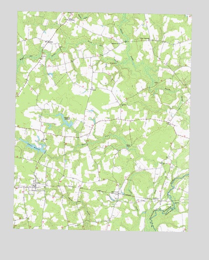
Sedley, VA USGS Topographic Map
Click on map above to begin viewing in our Map Viewer.

This topographic map contains these locations and features:
Feature Name Type Latitude Longitude GNIS ID View Map
Berea Church (historical)ChurchN36.7551°W76.9497°1738969View Map
BerlinPopulated PlaceN36.8577°W76.9775°1477110View Map
Beulahland ChurchChurchN36.8227°W76.9241°1463280View Map
Black CreekPopulated PlaceN36.7715°W76.9250°1477118View Map
Black CreekStreamN36.7626°W76.9011°1463477View Map
BurdettePopulated PlaceN36.7685°W76.8983°1499190View Map
Cattail SwampStreamN36.7596°W76.8977°1464566View Map
Cedar Grove ChurchChurchN36.7890°W76.8941°1464615View Map
CorinthPopulated PlaceN36.8313°W76.9455°1477225View Map
Corinth Friends ChurchChurchN36.8315°W76.9450°1738981View Map
Cottage Hill School (historical)SchoolN36.8154°W76.9808°1738982View Map
Doles CrossroadsPopulated PlaceN36.8602°W76.9044°1477267View Map
Ebenezer School (historical)SchoolN36.8732°W76.9622°1738992View Map
Jericho School (historical)SchoolN36.7521°W76.9819°1739001View Map
Johnson DamDamN36.7940°W76.9780°1490861View Map
Johnson MillpondReservoirN36.7975°W76.9852°1502048View Map
Longbranch School (historical)SchoolN36.8235°W76.9236°1739007View Map
Mount Carmel ChurchChurchN36.8015°W76.9800°1470842View Map
Nottoway Elementary SchoolSchoolN36.8420°W76.9860°2465386View Map
Pulleys CrossroadsPopulated PlaceN36.8710°W76.9638°1477651View Map
Rosenwald School (historical)SchoolN36.8574°W76.8877°1739022View Map
Round HillSummitN36.8463°W76.9283°1499993View Map
Round Hill SwampStreamN36.8504°W76.9194°1473581View Map
Sandy Hill School (historical)SchoolN36.7782°W76.9280°1739023View Map
Seacock CornerPopulated PlaceN36.8577°W76.9252°1500045View Map
SedleyPopulated PlaceN36.7760°W76.9841°1500050View Map
Sedley Census Designated PlaceCensusN36.7753°W76.9862°2629039View Map
Sedley Post OfficePost OfficeN36.7755°W76.9844°2519652View Map
Sedley Volunteer Fire Department Station 8BuildingN36.7747°W76.9844°2085939View Map
UnityPopulated PlaceN36.8126°W76.8897°1477831View Map
Wades PondLakeN36.7980°W76.9192°1476214View Map
Whitefields DamDamN36.8099°W76.9600°1490860View Map
Whitefields MillpondReservoirN36.8127°W76.9639°1502159View Map

Note: Coordinates in the location and feature list above are referenced to NAD83 datum.


Copyright (C) 2008-2024 Ryan Niemi / Sunset Dynamics ... All Rights Reserved