TopoQuest Logo
Do you find TopoQuest useful?
Help keep TopoQuest running and adding new maps/features by donating!
Bitcoin:  19c7KJd3qBynnjoSw5npx9KScwjBe4ifkT
Litecoin:  LXs6TkuXGGXo1vDsWCkWVdjQX94eUKd6ui
Home View Maps Find Maps Find Places Resources & Links


Vicksville, Virginia Topographic Map

USGS Map Title: Vicksville, VA
USGS Map MRC: 36077G1
DRG (GeoTIFF) Download: o36077g1.tif


Neighboring USGS Topographic Map Quads:


  Littleton, VA  
36077H2
 

  Manry, VA  
36077H1
 

  Ivor, VA  
36076H8
 

  Sebrell, VA  
36077G2
 

  Vicksville, VA  
36077G1
 

  Sedley, VA  
36076G8
 

  Capron, VA  
36077F2
 

  Courtland, VA  
36077F1
 

  Franklin, VA  
36076F8


Map MRC Location:

N37°
W78°
N37°
W77°
H8 H7 H6 H5 H4 H3 H2 H1
G8 G7 G6 G5 G4 G3 G2 G1
F8 F7 F6 F5 F4 F3 F2 F1
E8 E7 E6 E5 E4 E3 E2 E1
D8 D7 D6 D5 D4 D3 D2 D1
C8 C7 C6 C5 C4 C3 C2 C1
B8 B7 B6 B5 B4 B3 B2 B1
A8 A7 A6 A5 A4 A3 A2 A1
N36°
W78°
N36°
W77°

Vicksville, VA USGS 1:24K Topographic Map Preview:
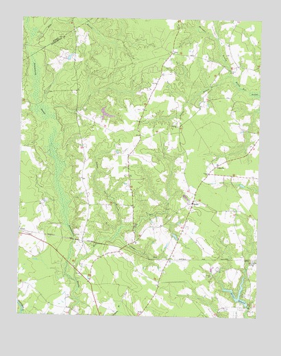
Vicksville, VA USGS Topographic Map
Click on map above to begin viewing in our Map Viewer.

This topographic map contains these locations and features:
Feature Name Type Latitude Longitude GNIS ID View Map
BealesPopulated PlaceN36.7974°W77.0341°1499099View Map
Cabin Point School (historical)SchoolN36.8532°W77.0977°1738974View Map
Capron DistrictCivilN36.7642°W77.1131°1927125View Map
Colgate Darden DamDamN36.7549°W77.0047°1490850View Map
Colgate Darden MillpondReservoirN36.7582°W77.0110°1490851View Map
Darden CampLocaleN36.7590°W77.0077°1465601View Map
Darden MillpondReservoirN36.7547°W77.0047°1465603View Map
Deep BranchStreamN36.8668°W77.1175°1465694View Map
DoryPopulated PlaceN36.8613°W77.0461°1477272View Map
Dory School (historical)SchoolN36.8471°W77.0533°1738988View Map
Horsepen BranchStreamN36.8518°W77.0152°1468283View Map
Horsepen BridgeBridgeN36.8540°W77.0158°1468287View Map
Indian BranchStreamN36.7871°W77.0716°1468458View Map
Indigo BranchStreamN36.8518°W77.0150°1468500View Map
Mill RunStreamN36.7651°W77.0944°1470531View Map
Pittman School (historical)SchoolN36.8274°W77.0630°1739017View Map
Saint Lukes ChurchChurchN36.8299°W77.0425°1473801View Map
Saint Pauls ChurchChurchN36.7729°W77.0014°1473869View Map
VicksvillePopulated PlaceN36.8135°W77.0222°1500257View Map
Village RunStreamN36.7843°W77.0736°1476190View Map
Zion ChurchChurchN36.7882°W77.0639°1474384View Map

Note: Coordinates in the location and feature list above are referenced to NAD83 datum.


Copyright (C) 2008-2024 Ryan Niemi / Sunset Dynamics ... All Rights Reserved