TopoQuest Logo
Do you find TopoQuest useful?
Help keep TopoQuest running and adding new maps/features by donating!
Bitcoin:  19c7KJd3qBynnjoSw5npx9KScwjBe4ifkT
Litecoin:  LXs6TkuXGGXo1vDsWCkWVdjQX94eUKd6ui
Home View Maps Find Maps Find Places Resources & Links


Sewanee, Tennessee Topographic Map

USGS Map Title: Sewanee, TN
USGS Map MRC: 35085B8
DRG (GeoTIFF) Download: o35085b8.tif


Neighboring USGS Topographic Map Quads:


  Capitol Hill, TN  
35086C1
 

  Alto, TN  
35085C8
 

  Burrow Cove, TN  
35085C7
 

  Winchester, TN  
35086B1
 

  Sewanee, TN  
35085B8
 

  Monteagle, TN  
35085B7
 

  Pitcher Ridge, TN  
35086A1
 

  Sinking Cove, TN  
35085A8
 

  Orme, TN  
35085A7


Map MRC Location:

N36°
W86°
N36°
W85°
H8 H7 H6 H5 H4 H3 H2 H1
G8 G7 G6 G5 G4 G3 G2 G1
F8 F7 F6 F5 F4 F3 F2 F1
E8 E7 E6 E5 E4 E3 E2 E1
D8 D7 D6 D5 D4 D3 D2 D1
C8 C7 C6 C5 C4 C3 C2 C1
B8 B7 B6 B5 B4 B3 B2 B1
A8 A7 A6 A5 A4 A3 A2 A1
N35°
W86°
N35°
W85°

Sewanee, TN USGS 1:24K Topographic Map Preview:
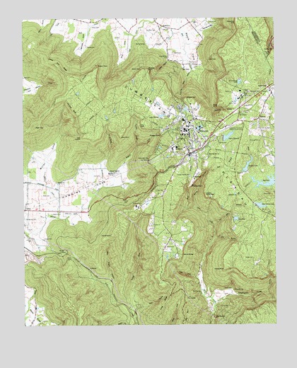
Sewanee, TN USGS Topographic Map
Click on map above to begin viewing in our Map Viewer.

This topographic map contains these locations and features:
Feature Name Type Latitude Longitude GNIS ID View Map
Anderson CemeteryCemeteryN35.1998°W85.8828°1275694View Map
Armfield BluffCliffN35.2131°W85.9764°1275856View Map
Arnett MineMineN35.2304°W85.9408°1318338View Map
Athletic Field DamDamN35.2151°W85.8966°1301662View Map
Athletic Field LakeReservoirN35.2158°W85.8956°1301661View Map
Barnes BranchStreamN35.1729°W85.9141°1276341View Map
Bennett CemeteryCemeteryN35.2384°W85.9680°1277010View Map
Bennett CoveValleyN35.2444°W85.9687°1305102View Map
Big BranchStreamN35.1604°W85.9053°1305203View Map
Big SpringSpringN35.1834°W85.9830°1277394View Map
Billy Ought HollowValleyN35.1414°W85.9581°1277475View Map
BobtownPopulated PlaceN35.1851°W85.9158°1277869View Map
Caldwell RidgeRidgeN35.2376°W85.8903°1311135View Map
Cape of Good HopeSummitN35.1773°W85.9091°1279626View Map
Cascade FallsFallsN35.2356°W85.8772°1279838View Map
Cedar HollowValleyN35.2331°W85.9267°1280077View Map
Champion CoveValleyN35.1340°W85.9053°1269439View Map
Cherry CemeteryCemeteryN35.2454°W85.9378°1280337View Map
Cherry PointCapeN35.2292°W85.9403°1280356View Map
Cherry SpringSpringN35.2398°W85.9389°1280357View Map
Cheston DamDamN35.2095°W85.9316°1307079View Map
Claibornes ViewSummitN35.2484°W85.8941°1280580View Map
Coolies RiftBasinN35.2370°W85.8755°1281155View Map
Cowan TunnelTunnelN35.1531°W85.9766°1281462View Map
Day LakeReservoirN35.1836°W85.8776°1282221View Map
Deep HollowValleyN35.1306°W85.9449°1282289View Map
Depot BranchStreamN35.1726°W85.9189°1282360View Map
Dick CoveValleyN35.2455°W85.9495°1282423View Map
Dodson MineMineN35.2309°W85.9633°1318336View Map
Dorans Stand (historical)LocaleN35.1701°W85.8786°1318348View Map
Dotson PointCapeN35.2306°W85.9630°1282676View Map
Eastern Star CemeteryCemeteryN35.2042°W85.9158°1318350View Map
Elliot PointCapeN35.2020°W85.9516°1283666View Map
Emile Huntzeker MineMineN35.2212°W85.9272°1318340View Map
Eva LakeReservoirN35.1682°W85.8946°1283891View Map
Franklin County AirportAirportN35.2053°W85.8997°1301315View Map
Garner CemeteryCemeteryN35.1326°W85.9028°1285173View Map
Garner CemeteryCemeteryN35.1398°W85.8972°1285174View Map
Gipson CemeteryCemeteryN35.2359°W85.9250°1285458View Map
Grace ChurchChurchN35.1659°W85.9355°1285781View Map
Greens ViewLocaleN35.2176°W85.9186°1315158View Map
Grundy EMS Franklin CountyBuildingN35.2074°W85.9134°2697401View Map
Gudger CemeteryCemeteryN35.1520°W85.8861°1286371View Map
Harrison CemeteryCemeteryN35.2045°W85.8814°1287012View Map
Harrison SpringSpringN35.1945°W85.9079°1287027View Map
Hawkins CemeteryCemeteryN35.1604°W85.9958°1287175View Map
Hawkins CemeteryCemeteryN35.1706°W85.9858°1287176View Map
Hawkins CoveValleyN35.1750°W85.9837°1287186View Map
Hawkins SpringSpringN35.1873°W85.9550°1287192View Map
Henley CemeteryCemeteryN35.2484°W85.9072°1287415View Map
Henley HollowValleyN35.2451°W85.9114°1287421View Map
High TopSummitN35.2065°W85.9944°1287721View Map
Holder CemeteryCemeteryN35.1781°W85.9866°1288029View Map
Ives CemeteryCemeteryN35.1862°W85.9622°1289112View Map
Jackson CemeteryCemeteryN35.1604°W85.9903°1289191View Map
Jackson LakeReservoirN35.1897°W85.8888°1307074View Map
Jackson Lake DamDamN35.1876°W85.8891°1307075View Map
Kelley MineMineN35.1479°W85.8983°1318347View Map
Kelleys PointCapeN35.1479°W85.9005°1290014View Map
Kirby-Smith BranchStreamN35.1817°W85.9605°1290289View Map
Kirk SpringSpringN35.1386°W85.9124°1290297View Map
Lake ChestonReservoirN35.2102°W85.9313°1280429View Map
Lake O'DonnellReservoirN35.2018°W85.8983°1307077View Map
Lake O'Donnell DamDamN35.2012°W85.9005°1307076View Map
Lands End RidgeRidgeN35.2309°W85.9828°1290590View Map
Laurel BranchStreamN35.1384°W85.8794°1290689View Map
Little CoveValleyN35.1445°W85.9142°1291432View Map
Long CemeteryCemeteryN35.2456°W85.9305°1291915View Map
Long RidgeRidgeN35.1337°W85.9300°1291998View Map
Long SpringSpringN35.2345°W85.9278°1292010View Map
Lost CoveValleyN35.1347°W85.9088°1292069View Map
Lost CreekStreamN35.1281°W85.9058°1292072View Map
Marlow Field CemeteryCemeteryN35.1315°W85.9625°1318334View Map
McDowell CemeteryCemeteryN35.1467°W85.9314°1318346View Map
MidwayPopulated PlaceN35.2092°W85.8828°1293723View Map
Midway ChurchChurchN35.2204°W85.8775°1293730View Map
Midway School (historical)SchoolN35.2073°W85.8833°1318354View Map
Miller CemeteryCemeteryN35.1709°W85.9797°1293912View Map
Miller CoveValleyN35.1846°W85.9921°1293941View Map
Miller CreekStreamN35.1690°W85.9828°1293946View Map
Mont Milner LakeReservoirN35.1735°W85.8825°1307071View Map
Mont Milner Lake DamDamN35.1734°W85.8841°1307072View Map
Morgans SteepCliffN35.2023°W85.9316°1294383View Map
O'Dear CemeteryCemeteryN35.1798°W85.9303°1296033View Map
Otey Memorial Parish ChurchChurchN35.1976°W85.9189°1318342View Map
Otey ViewSummitN35.2065°W85.9416°1296513View Map
Pearson SpringSpringN35.1876°W85.9572°1297083View Map
Pinckney BranchStreamN35.1984°W85.9433°1297502View Map
Piney PointCapeN35.2145°W85.9030°1297648View Map
Point DisappointmentCapeN35.1817°W85.9172°1298006View Map
Polk LookoutLocaleN35.2017°W85.9703°1298063View Map
Prince SpringSpringN35.1392°W85.8960°1298544View Map
Reuben CreekStreamN35.1254°W85.9441°1299235View Map
Roark CovePopulated PlaceN35.2470°W85.9303°1315817View Map
Roarks Cove School (historical)SchoolN35.2462°W85.9303°1318337View Map
RockledgePopulated PlaceN35.1479°W85.9675°1315828View Map
Rose BranchStreamN35.1879°W85.9083°1300060View Map
Running Knob HollowValleyN35.2285°W85.9161°1300250View Map
Rutledge PointCapeN35.2292°W85.9375°1300367View Map
Rutledge Point MineMineN35.2287°W85.9366°1318339View Map
Saint AndrewsPopulated PlaceN35.2112°W85.8925°1315859View Map
Saint Andrews CemeteryCemeteryN35.2192°W85.8916°1318352View Map
Saint Andrews DamDamN35.2251°W85.8925°1307085View Map
Saint Andrews LakeReservoirN35.2239°W85.8923°1307084View Map
Saint Andrews Post OfficePost OfficeN35.2117°W85.8922°1650981View Map
Saint Andrews SchoolSchoolN35.2176°W85.8908°1300418View Map
Saint MarysPopulated PlaceN35.1737°W85.9416°1647461View Map
Saint Marys CemeteryCemeteryN35.1748°W85.9414°1300477View Map
Saint Marys School (historical)SchoolN35.1737°W85.9433°1318344View Map
Sand SwitchPopulated PlaceN35.2217°W85.8783°1300680View Map
SewaneePopulated PlaceN35.2031°W85.9211°1301113View Map
Sewanee Academy (historical)SchoolN35.1976°W85.9239°1301114View Map
Sewanee Census Designated PlaceCensusN35.1975°W85.9214°2402841View Map
Sewanee ChurchChurchN35.1573°W85.9250°1301115View Map
Sewanee Cumberland Presbyterian ChurchChurchN35.1887°W85.9133°1318343View Map
Sewanee Division (historical)CensusN35.1923°W85.9147°1648693View Map
Sewanee PlateauPlainN35.2176°W85.9475°1311136View Map
Sewanee Post OfficePost OfficeN35.1962°W85.9178°1650980View Map
Sewanee Public SchoolSchoolN35.1973°W85.9200°1318341View Map
Sewanee Volunteer Fire Department Station 1BuildingN35.2048°W85.9213°2654877View Map
Sewanee Volunteer Fire Department Station 2BuildingN35.2036°W85.9174°2654715View Map
Sewell-Bowers CemeteryCemeteryN35.1901°W85.9658°1318335View Map
Shakerag HollowValleyN35.2127°W85.9050°1301205View Map
Shakerag Hollow MineMineN35.2112°W85.9044°1318353View Map
Southern Tennessee Medical Center Emerald Hodgson HospitalHospitalN35.2080°W85.9139°1318351View Map
Swann CemeteryCemeteryN35.2465°W85.9658°1271949View Map
Talleys ForkStreamN35.1281°W85.9455°1303997View Map
Tennessee Department of Agriculture Division of Forestry Franklin DistrictBuildingN35.2200°W85.8879°2654693View Map
The Big SinkBasinN35.1281°W85.9055°1272371View Map
The SaddleGapN35.1356°W85.9194°1272436View Map
The University of the SouthSchoolN35.2048°W85.9197°1273274View Map
Tunnel PointCapeN35.1617°W85.9566°1272988View Map
Two Mile BranchStreamN35.1656°W85.9055°1273133View Map
University CemeteryCemeteryN35.2004°W85.9125°1318349View Map
University ViewLocaleN35.1931°W85.9372°1314440View Map
Walker SpringSpringN35.2270°W85.9158°1311169View Map
West CemeteryCemeteryN35.2259°W85.9997°1274138View Map
Wiggins CreekStreamN35.1820°W85.9564°1274516View Map
Wise CemeteryCemeteryN35.1656°W85.9219°1318345View Map
WUTS-FM (Sewanee)TowerN35.2056°W85.9186°1640033View Map

Note: Coordinates in the location and feature list above are referenced to NAD83 datum.


Copyright (C) 2008-2024 Ryan Niemi / Sunset Dynamics ... All Rights Reserved