TopoQuest Logo
Do you find TopoQuest useful?
Help keep TopoQuest running and adding new maps/features by donating!
Bitcoin:  19c7KJd3qBynnjoSw5npx9KScwjBe4ifkT
Litecoin:  LXs6TkuXGGXo1vDsWCkWVdjQX94eUKd6ui
Home View Maps Find Maps Find Places Resources & Links


Capitol Hill, Tennessee Topographic Map

USGS Map Title: Capitol Hill, TN
USGS Map MRC: 35086C1
DRG (GeoTIFF) Download: o35086c1.tif


Neighboring USGS Topographic Map Quads:


  Normandy Lake, TN  
35086D2
 

  Manchester, TN  
35086D1
 

  Hillsboro, TN  
35085D8
 

  Tullahoma, TN  
35086C2
 

  Capitol Hill, TN  
35086C1
 

  Alto, TN  
35085C8
 

  Belvidere, TN  
35086B2
 

  Winchester, TN  
35086B1
 

  Sewanee, TN  
35085B8


Map MRC Location:

N36°
W87°
N36°
W86°
H8 H7 H6 H5 H4 H3 H2 H1
G8 G7 G6 G5 G4 G3 G2 G1
F8 F7 F6 F5 F4 F3 F2 F1
E8 E7 E6 E5 E4 E3 E2 E1
D8 D7 D6 D5 D4 D3 D2 D1
C8 C7 C6 C5 C4 C3 C2 C1
B8 B7 B6 B5 B4 B3 B2 B1
A8 A7 A6 A5 A4 A3 A2 A1
N35°
W87°
N35°
W86°

Capitol Hill, TN USGS 1:24K Topographic Map Preview:
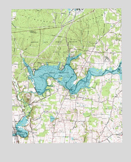
Capitol Hill, TN USGS Topographic Map
Click on map above to begin viewing in our Map Viewer.

This topographic map contains these locations and features:
Feature Name Type Latitude Longitude GNIS ID View Map
Ansonia Depot (historical)LocaleN35.2567°W86.1194°1318445View Map
Ansonia Mills (historical)LocaleN35.2615°W86.1200°1318444View Map
Beth Page CemeteryCemeteryN35.2776°W86.1108°1305111View Map
Bethpage Church (historical)ChurchN35.2770°W86.1105°1644955View Map
Bluehole HollowValleyN35.3538°W86.1221°1277822View Map
Bradley CreekStreamN35.3195°W86.0030°1305382View Map
Braton CemeteryCemeteryN35.2506°W86.0272°1278249View Map
Brick Church (historical)ChurchN35.3365°W86.0467°1318447View Map
Brumalow CreekStreamN35.3279°W86.0592°1305470View Map
Buckner CemeteryCemeteryN35.2701°W86.0397°1278879View Map
Buncombe (historical)Populated PlaceN35.3251°W86.0833°1311181View Map
CallsPopulated PlaceN35.3462°W86.0053°1279340View Map
Camp ArrowheadLocaleN35.3101°W86.0783°1279369View Map
Camp CemeteryCemeteryN35.3137°W86.0130°1279379View Map
Camp TannassieLocaleN35.3215°W86.0947°1279412View Map
Capitol HillPopulated PlaceN35.2912°W86.0653°1314792View Map
Capitol Hill Church of ChristChurchN35.2926°W86.0655°1318454View Map
Capitol Hill School (historical)SchoolN35.2912°W86.0661°1318455View Map
Center Grove Church (historical)ChurchN35.3242°W86.0914°1318440View Map
Childer CreekStreamN35.3017°W86.0361°1280450View Map
Coffee County Recreation AreaParkN35.3306°W86.0569°1280863View Map
Commissioner District 6CivilN35.2882°W86.0502°2464529View Map
Corn CemeteryCemeteryN35.2565°W86.1075°1306118View Map
Davidsons Mill (historical)LocaleN35.3192°W86.0041°1318450View Map
Duncan CemeteryCemeteryN35.2820°W86.0564°1318460View Map
Duncan LakeLakeN35.2729°W86.0798°1283171View Map
Duncans Stagecoach CemeteryCemeteryN35.2759°W86.0730°1318457View Map
DuncantownPopulated PlaceN35.3254°W86.0405°1314984View Map
Duncantown Census Designated PlaceCensusN35.3333°W86.0262°2586050View Map
Elder CemeteryCemeteryN35.3090°W86.0697°1318452View Map
Elder IslandIslandN35.3101°W86.0700°1283603View Map
Elk River ChurchChurchN35.2929°W86.0542°1283643View Map
Elk River DamDamN35.2984°W86.0969°1306418View Map
Estill Springs BridgeBridgeN35.2584°W86.1217°1318446View Map
Featherston CemeteryCemeteryN35.2554°W86.0158°1284182View Map
Featherston CemeteryCemeteryN35.2767°W86.0355°1284183View Map
Fields CemeteryCemeteryN35.2579°W86.0033°1284246View Map
Finney CemeteryCemeteryN35.2704°W86.0428°1284280View Map
Franklin County ParkParkN35.3079°W86.0739°1284829View Map
Gossage CemeteryCemeteryN35.2742°W86.1041°1318443View Map
Gossage Ford (historical)CrossingN35.2754°W86.1092°1644956View Map
Gum CreekPopulated PlaceN35.2926°W86.0069°1286403View Map
Gum CreekStreamN35.3070°W86.0016°1269611View Map
Gum Creek CemeteryCemeteryN35.2929°W86.0064°1318466View Map
Gum Creek Cumberland Presbyterian ChurchChurchN35.2926°W86.0069°1318465View Map
Gum Creek School (historical)SchoolN35.2923°W86.0075°1318464View Map
Hardaway BranchStreamN35.3337°W86.0594°1286802View Map
Herriford CemeteryCemeteryN35.2726°W86.0225°1287501View Map
Holland CemeteryCemeteryN35.2509°W86.0397°1318461View Map
Holland PondLakeN35.2542°W86.0570°1288065View Map
Jones Ford (historical)CrossingN35.3076°W86.0861°1311182View Map
Kemp Ford (historical)CrossingN35.3154°W86.0125°1311183View Map
Knight Church (historical)ChurchN35.2626°W86.0569°1318459View Map
Lawson HollowValleyN35.3225°W86.0715°1290814View Map
Leach Bridge (historical)BridgeN35.3145°W86.0755°1318451View Map
Little MountainSummitN35.2517°W86.0425°1269742View Map
Lye PondLakeN35.2794°W86.0884°1292321View Map
Morris CemeteryCemeteryN35.2654°W86.0025°1294414View Map
Morris Ferry (historical)CrossingN35.2995°W86.0597°1644957View Map
Morris Ferry BridgeBridgeN35.3023°W86.0567°1294427View Map
Morris Ferry DockLocaleN35.2962°W86.0575°1294428View Map
Morris Ford (historical)CrossingN35.2995°W86.0597°1644958View Map
New Brick ChurchChurchN35.3342°W86.0258°1295448View Map
New Brick Church CemeteryCemeteryN35.3334°W86.0261°1318449View Map
Oak Grove Elementary SchoolSchoolN35.2567°W86.0036°1318463View Map
Old Bethpage CemeteryCemeteryN35.2829°W86.1133°1318442View Map
Old Grays Mill CemeteryCemeteryN35.2873°W86.1058°1318441View Map
Partin CemeteryCemeteryN35.2551°W86.0022°1296901View Map
Paynes CemeteryCemeteryN35.2779°W86.0741°1318456View Map
Paynes ChurchChurchN35.2781°W86.0730°1297024View Map
Penile HillPopulated PlaceN35.2701°W86.0528°1647466View Map
Possum BranchStreamN35.3190°W86.0225°1298290View Map
Prairie Chapel CemeteryCemeteryN35.2737°W86.0289°1298444View Map
Roe CemeteryCemeteryN35.2740°W86.0403°1318462View Map
Rowland CreekStreamN35.3126°W86.1017°1269913View Map
Scenic View Golf CourseLocaleN35.2701°W86.0744°1300875View Map
Secondary Retention ReservoirReservoirN35.3743°W86.0521°1301778View Map
Secondary Retention Reservoir DamDamN35.3734°W86.0533°1301779View Map
Smith CemeteryCemeteryN35.2642°W86.0800°1318458View Map
Spring CreekStreamN35.2967°W86.1175°1271076View Map
Spring Creek CemeteryCemeteryN35.3062°W86.1155°1318439View Map
Stampers Mill (historical)LocaleN35.3229°W86.0605°1318448View Map
University of Tennessee Space InstituteSchoolN35.3192°W86.1005°1273278View Map
Watson CemeteryCemeteryN35.2829°W86.0044°1273917View Map
Woods ReservoirReservoirN35.3121°W86.0601°1275089View Map

Note: Coordinates in the location and feature list above are referenced to NAD83 datum.


Copyright (C) 2008-2025 Ryan Niemi / Sunset Dynamics ... All Rights Reserved